Kabylie
| Kabylia Tamurt n Iqvayliyen ⵜⴰⵎⵓⵔⵜ ⵏ ⵉⵇⴱⴰⵢⵍⵉⵢⴻⵏ | |
|---|---|
| Kabylie | |
| Coordinates: 37°49′N 4°50′E / 37.817°N 4.833°E | |
| Country |
|
| Provinces - Wilayas | Tizi Ouzou, Béjaïa, Sétif, Bouïra, Jijel, Boumerdès, Bordj Bou Arréridj, Skikda, Mila, M'Sila |
| Area | |
| • Total | 25,000 km2 (10,000 sq mi) |
| Population (2012) | |
| • Total | 7,575,643 |
| • Density | 300/km2 (780/sq mi) |
| Demonym(s) |
Kabyles Iqvayliyen |
| ISO 3166-2 | DZA |
| Area code | +213 (Algéria) |
| Languages |
Kabyle French language Algerian Arabic Literary Arabic |
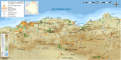
Kabylia or Kabylie (Berber: ⵜⴰⵎⵓⵔⵜ ⵏ ⵉⵇⴱⴰⵢⵍⵉⵢⴻⵏ, Tamurt n Iqvayliyen), is a natural and historical region in the north of Algeria.
It is part of the Tell Atlas mountains and is located at the edge of the Mediterranean Sea. Kabylia covers several provinces of Algeria: the whole of Tizi Ouzou and Bejaia (Bgayet), most of Bouira (Tubirett) and parts of the wilayas of Boumerdes, Setif, Bordj Bou Arreridj and Jijel. Gouraya National Park and Djurdjura National Park are also located in Kabylia.
History
Antiquity
Kabylia was a part of the Kingdom of Numidia (202 BC – 46 BC). It was later taken over by the Roman Empire, and became split between the provinces of Africa and Mauretania Caesariensis. In AD 289, the Quinquegentiani, a Berber tribe from Kabylia, rebelled against Roman rule; the rebels were defeated in a year-long Roman offensive in the years 297-298, in which the Quinquegentiani were driven from their homeland in Kabylia, into the Sahara.
Middle Ages
The Kabyle country remained as unconquerable as it was inaccessible to the Ottoman deys. They generally established a few coastal military settlements and some in valleys, where they imposed the rule of the Islamic Ottoman Empire. The mountainous core land, however, remained independent. Islam was gradually adopted through peaceful means, namely the Marabout movement. Some scholars argue that this is the reason of the Kabyles' indifference towards Islam. The Ottoman threat disappeared with the arrival of the European and American navies to conquer North Africa.
Regency of Algiers
During the Regency of Algiers, most of Kabylia was independent. Kabylia was split into two main kingdoms, the Kingdom of Kuku in modern Tizi Ouzou, and the Kingdom of Ait Abbas in modern Béjaïa.
Modern age
.jpg)
Though the region was the last stronghold against French colonization,[1] the area was gradually taken over by the French from 1857, despite vigorous local resistance by the local population led by leaders such as Faḍma n Sumer, continuing as late as Mokrani's rebellion in 1871. Much land was confiscated in this period from the more recalcitrant tribes and given to French pieds-noirs. Many arrests and deportations were carried out by the French in response to uprisings, mainly to New Caledonia. Colonization also resulted in an acceleration of the emigration into other areas of the country and outside of it.
Algerian migrant workers in France organized the first party promoting independence in the 1920s. Messali Hadj, Imache Amar, Si Djilani, and Belkacem Radjef rapidly built a strong following throughout France and Algeria in the 1930s and actively trained militants who became key players during the struggle for independence and in building an independent Algerian state.
During the War of Independence (1954–1962), Kabylia was one of the areas most affected because of the importance of the maquis (aided by the mountainous terrain) and resultant French counter-insurgency operations. Several historic leaders of the FLN came from this region, including Hocine Aït Ahmed, Abane Ramdane, and Krim Belkacem.
Geography
Main features:
- Great Kabylia which runs from Thénia (west) to Bgayet (Bejaia) (east), and from the Mediterranean Sea (north) to the valley of Soummam (south), that is to say, 200 km by 100 km, beginning 50 km from Algiers, the capital of Algeria.
- Kabylia of Bibans and Kabylia of Babors, which form the Small Kabylia.
Three large chains of mountains occupy most of the area:
- In the north, the mountain range of maritime Kabylia, culminating with Tifrit n'Ait El Hadj (Tamgout 1278 m)
- In the south, the Djurdjura, dominating the valley of Soummam, culminating with Lalla-Khedidja (2308 m)
- Between the two lies the mountain range of Agawa, which is the most populous and is 800 m high on average. The largest town of Great Kabylia, Tizi Ouzou, lies in that mountain range. At Iraten (formerly "Fort-National" in French occupation), which numbered 28,000 inhabitants in 2001, is the highest urban centre of the area.
The region's size is similar to that of Denmark.[2]
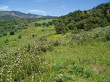
Ecology
There are a number of flora and fauna associated with this region. Notable is a population of the endangered primate, Barbary macaque, Macaca sylvanus, whose prehistoric range encompassed a much wider span than the present limited populations in Algeria, Morocco and Gibraltar.[3]
Population
The area is populated by the Kabyle, a Berber ethnic group,They speak the Kabyle variety of Berber. Since the Berber Spring in 1980, Kabyles have been at the forefront of the fight for recognition of the Berber language as an official one in Algeria (see Languages of Algeria) and for secularism (laïcité) in the country.
Economy
The traditional economy of the area is based on arboriculture (orchards, olive trees) and on the craft industry (tapestry or pottery). The mountain and hill farming is gradually giving way to local industry (textile and agro-alimentary).
Today Kabylia is one of the most industrialised parts of Algeria.[4] Kabylia produces less than 15% of Algerian GDP (excluding oil and gas).[5] Industries include: pharmaceutical industry in Bgayet Bejaia, agro-alimentary in Ifri and Akbou, mechanical industry in Tizi Ouzou and other small towns of western Kabylia, and petrochemical industry and oil refining in Bgayet Bejaia.[5]
Bgayet Bejaia's port is the second biggest in Algeria after Algiers, and the 6th largest on the Mediterranean Sea.
See also
- Portal:Berbers
- Portal:Algeria
References
- ↑ "Kabylia - Oxford Islamic Studies Online". Oxfordislamicstudies.com. 2008-05-06. Retrieved 2015-03-06.
- ↑ "Colonised by the Arabs, Abandoned by the World | Inter Press Service". Ipsnews.net. 2012-08-07. Retrieved 2015-03-06.
- ↑ "Barbary Macaque (Macaca sylvanus) - iGoTerra.com". Globaltwitcher.auderis.se. Retrieved 2015-03-06.
- ↑ "Tmurt Iqvayliyen ass-agi", Maxime Ait Kaki
- 1 2 "Tadamsa taqbaylit", Saεid Duman
External links
| Wikimedia Commons has media related to Kabylie. |
Coordinates: 36°49′01″N 4°18′00″E / 36.817°N 4.300°E