Kamela, Oregon
Kamela is an unincorporated community in Union County, Oregon, United States.[1] It is located west of Interstate 84 about 20 miles northwest of La Grande.[2]
There are several stories about how the community got its name.[3] Among the explanations are that it was made up by combining the initials of the civil engineers working on the local railroad construction, or that it is the Cayuse word for "tree".[3] Another informant stated that when the locale was a stagecoach station, it was called "Summit Station", but when the Union Pacific Railroad was built through the area, a different name was needed.[3] Local doctor W. C. McKay was asked to supply a number of names of Native American origin to be used for various stations along the line.[3] Kamela was selected from this list. According to an interpreter at the Umatilla Agency, the word meant "tamarack" in the Nez Perce language, however, L. C. McKay, the daughter of Dr. McKay, was sure the word meant "summit".[3] Another station on the line, Mikecha, was made up of the names of three civil engineers—Mink, Kennedy, and Chalk—and the compiler of Oregon Geographic Names believed that this name was confused with Kamela.[3] Kamela post office ran from 1887 to 1949.[3]
Kamela is the highest railroad pass in the Blue Mountains, with an elevation of 4,206 feet (1,282 m).[4] Kamela had a roundhouse and served as a wood and timber handling point for the railroad.[5] In 1904, the population of the community was 220.[5] In 1940 Kamela had a population of 27.[4] At one time the community had a school.[6] One of the last Oregon train robberies began in Kamela in 1914.[7][8]
References
- ↑ "Kamela". Geographic Names Information System. United States Geological Survey. November 28, 1980. Retrieved February 6, 2012.
- ↑ Oregon Atlas & Gazetteer (7th ed.). Yarmouth, Maine: DeLorme. 2008. p. 74. ISBN 0-89933-347-8.
- 1 2 3 4 5 6 7 McArthur, Lewis A.; McArthur, Lewis L. (2003) [1928]. Oregon Geographic Names (7th ed.). Portland, Oregon: Oregon Historical Society Press. p. 523–524. ISBN 978-0875952772.
- 1 2 Writers' Program of the Work Projects Administration in the State of Oregon (1940). Oregon: End of the Trail. American Guide Series. Portland, Oregon: Binfords & Mort. p. 258. OCLC 4874569.
- 1 2 Wood, Stanley (1904). Over the Range to the Golden Gate A Complete Tourist's Guide To Colorado, New Mexico, Utah, Nevada, California, Oregon, Puget Sound, and the Great Northwest. p. 316.
- ↑ "County Superintendents' Department: Union County". Oregon Teachers Monthly. Oregon State Teachers' Association. 21 (1): 99. September 1916.
- ↑ Patterson, Richard M. (1985). Historical Atlas of the Outlaw West. Boulder, Colorado: Johnson Publishing Company. ISBN 0-933472-89-7.
- ↑ Mason, Dick (October 17, 2011). "Was there a train robbery at Kamela many years ago?". The Observer. Retrieved February 6, 2012.
External links
- Images of Kamela from Flickr
Coordinates: 45°26′03″N 118°23′37″W / 45.434296°N 118.393568°W
Municipalities and communities of Union County, Oregon, United States | ||
|---|---|---|
| Cities | 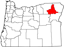 | |
| Unincorporated communities | ||
| Indian reservation | ||
| Ghost town | ||