Karub District
This article is about the district formerly known as Chamdo County. For the town, see Chengguan, Chamdo. For the city, see Chamdo.
| Karub 卡若区 • མཁར་རོ་ཆུས། | |
|---|---|
| District | |
|
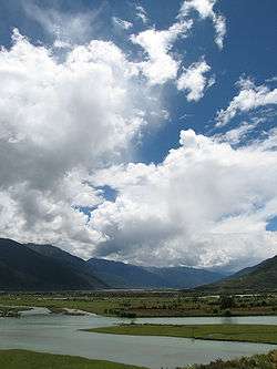
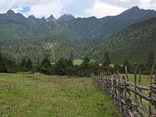
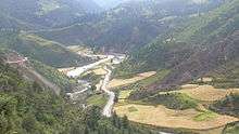
South of Karub | |
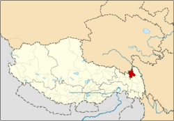 Location of Chamdo County within Tibet | |
| Coordinates: 32°16′34″N 97°15′41″E / 32.27611°N 97.26139°E | |
| Country | China |
| Province | Tibet |
| Prefecture | Qamdo |
| Capital | Chamdo |
| Time zone | China Standard (UTC+8) |
Karub District (other spellings: Karuo District, Kharro District) is a district in Qamdo, the district is synonymous referred to as Chamdo, Qamdo, or Chengguan in the Tibet Autonomous Region of China, and the seat of government of Qamdo. Karub has an area of 10,700 km² and a population of 78,000, of which 90% are Tibetan. The average temperature is 7.6 °C, with average temperatures of −2.3 °C in January and 16.3 °C in July. The average precipitation is 467 mm per year.
Popular with tourists are the Galden Jampaling Monastery in the capital and the salt mines and hot springs at Yangjing.
Administrative divisions
Karub administers 3 towns and 12 townships.
| Name | Hanzi | Hanyu Pinyin | Tibetan | Wylie | Population (2010)[1] | Area (km²) |
|---|---|---|---|---|---|---|
| Chengguan Town | 城关镇 | Chéngguān Zhèn | ཁྲིན་ཀོན་རྡལ་ | khrin kon rdal | 45,861 | 195.39 |
| Guro Town | 俄洛镇 | Éluò Zhèn | འགུ་རོ་ | agu ro | 6,502 | 776.74 |
| Karub Town | 卡若镇 | kǎ ruò Zhèn | མཁར་རོ་ | mkhar ro | 3,955 | 649.42 |
| Mongda Township | 芒达乡 | Mángdá Xiāng | རྨོ་མདའ་ | rmo mda' | 3,595 | 440.24 |
| Sagang Township | 沙贡乡 | Shāgòng Xiāng | ས་རྒང་ | sa rgang | 5,079 | 589.70 |
| Ormaika Township | 若巴乡 | Ruòbā Xiāng | ཨོར་སྨད་ཁ་ | or smad kha | 3,400 | 897.33 |
| Ngêxi Township | 埃西乡 | Āixī Xiāng | རྔེ་གཤེས་ | rnge gshes | 4,344 | 422.93 |
| Ruxi Township | 如意乡 | Rúyì Xiāng | རུ་བཞི་ | ru bzhi | 3,403 | 329.80 |
| Retong Township | 日通乡 | Rìtōng Xiāng | རེ་ཐོང་ | re thong | 4,925 | 546.76 |
| Cêrwai Township | 柴维乡 | Cháiwéi Xiāng | ཚེར་དབད་ | tsher dbad | 7,338 | 946.19 |
| Toba Township | 妥坝乡 | Tuǒbà Xiāng | ཐོ་པ་ | tho ba | 7,386 | 1,769.10 |
| Karma Township | 嘎玛乡 | Gāmǎ Xiāng | ཀ་རྨ་ | ka rma | 3,806 | 498.93 |
| Mainda Township | 面达乡 | Miàndá Xiāng | སྨན་མདའ་ | sman mda' | 5,995 | 1,085.23 |
| Yorba Township | 约巴乡 | Yuēbā Xiāng | ཡོར་པ་ | yor pa | 3,736 | 486.81 |
| Latog Township | 拉多乡 | Lāduō Xiāng | ལྷ་ཐོག་ | lha thog | 7,175 | 1,728.35 |
References
- ↑ shi, Guo wu yuan ren kou pu cha ban gong; council, Guo jia tong ji ju ren kou he jiu ye tong ji si bian = Tabulation on the 2010 population census of the people's republic of China by township / compiled by Population census office under the state; population, Department of; statistics, employment statistics national bureau of (2012). Zhongguo 2010 nian ren kou pu cha fen xiang, zhen, jie dao zi liao (Di 1 ban. ed.). Beijing Shi: Zhongguo tong ji chu ban she. ISBN 978-7-5037-6660-2.
External links
-
 Media related to Karub District at Wikimedia Commons
See also

Coordinates: 32°16′34″N 97°15′41″E / 32.27611°N 97.26139°E
This article is issued from Wikipedia - version of the 6/11/2016. The text is available under the Creative Commons Attribution/Share Alike but additional terms may apply for the media files.