Lhorong County
| Lhorong County 洛隆县 • ལྷོ་རོང་རྫོང་། | |
|---|---|
| County | |
| Tibetan transcription(s) | |
| • Wylie transliteration | lho rong rdzong |
| Chinese transcription(s) | |
| • Traditional | 洛隆縣 |
| • Pinyin | Luòlóng Xiàn |
|
| |
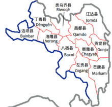
 Location of Lhorong County within Tibet | |
| Coordinates: 30°42′N 96°9′E / 30.700°N 96.150°E | |
| Country | People's Republic of China |
| Region | Tibet |
| Prefecture | Chamdo Prefecture |
| County seat | Lhorong |
| Area | |
| • Total | 8,108 km2 (3,131 sq mi) |
| Population (2003) | |
| • Total | 40,000 |
| Time zone | China Standard (UTC+8) |
Lhorong County is a county of the Qamdo Prefecture in the Tibet Autonomous Region. The county covers an area of 8,108 km2 (3,131 sq mi) and has a population of around 40,000 as of 2003. The word Lhorong means "valley in the south" or "river in the south" in Tibetan.
Geography and climate
Lhorong County is located in the northeast of the Tibet Autonomous Region, in the eastern Qinghai-Tibet Plateau and contains some 100 kilometres of the Nu River (Salween River).The Nu River flows through Tibet into Sichuan into Gongshan Dulong and Nu Autonomous County of Yunnan Province. It later flows through Lushui County and into Burma, eventually into the Indian Ocean. Lhorong County lies to the south-west of the Qamdo Prefecture. Banbar County lies to the northwest, Baxoi County lies across the river to the east, Banbar County to the west, Dêngqên County to the north, and Riwoqê County to the northeast. From east to west the county is 127 kilometers and from north to south the greatest distance of is 105 kilometres.[1] A county has a total area of 8048.4 square kikometres. The total population is around 36,000 people (1999), with estimates in 2003 being around 40,000.[1] Other rivers of Lhorong County include the Jalan Song, Maqu, and the Zhuoma Lang. The county also contains numerous small lakes which the locals compare to 21 fairies.[2]
The county has a temperate semi-arid plateau monsoon climate, with an average annual temperature of 5.1 ℃, the maximum air temperature (in July) being 14.5 ℃. The annual extreme minimum temperature is -10.1 ℃ and annual mean maximum temperature is 31.2 ℃.[1] The country experiences 2,500 hours of sunshine annually on average, with a frost-free period of 120 days or so. The annual average rainfall is 439.7 millimeters, with much rain in August. Annual average relative humidity is around 50-55%.[1]
Economy
The county is semi-agricultural, with an area of 88800 mu of cultivated land per capita, a grassland area of 400.9 hectares, and 24,797 hectares of forest. Lhorong County has reserves of gold, silver, copper, lead and zinc and other minerals such as mercury, arsenic, tin, marble etc.[1] The country contains 7 townships, 4 of which have town status, 76 administrative village municipalities and a total of 289 villages.[1] Lhorong County, has a county-level People's Hospital (MCH station, health and epidemic prevention stations), 11 small rural health clinics across the country and there is a Tibetan school. In recent years there has been a development of private medicine and pharmacology, mainly for the grassroots peasants and herdsmen in masses.[1] Education is taught bilingually in Tibetan and Chinese and the current school-age children enrollment rate is 99.66%.[1]
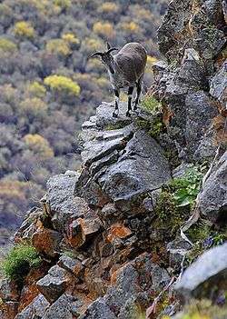
Wildlife include deer, bison, bear, leopard, monkey, Himalayan blue sheep (bharal), argali, wolves, foxes etc.[1] Lhorong County contains rich fertile land suitable for agriculture. The main crops are spring wheat, winter wheat, spring barley, winter barley, peas, rapeseed, potatoes, round root, etc. and a speciality, Lhorong tsampa butter.[1] 11 townships in the county belong to the farming and animal husbandry. Livestock include mainly yak, sheep, goats, cattle, horses, mules, pigs etc. and meat, dairy products, hides and wool is produced and in 2002 amounted to a revenue of 1.96 million yuan.[1] Grain and oil processing plants, brickwork, breeding factories and other enterprises exist in Lhorong County.[1] Folk handicrafts, ethnic costumes, ethnic handicraft production also employs people.
The county has a county-level radio and television transmitter and a township-level radio and television transmitter. In Lhorong County there is a Lhorong County Branch of the Agricultural Bank of China, township credit unions and other financial institutions, primarily for farmers and herdsmen in agricultural and pastoral development.[1] Lhorong County has a post office, which has opened a 24-hour electronic remittance business, a bureau, and now has controlled telephone, fax, telegraph and postal services and 163 computers have Internet access as of 2008.[1] Lhorong county town has numerous guest houses and a variety of small food and beverage outlets.
Subdivisions
Lhorong County contains 7 townships, 4 of which have town status, 76 administrative village municipalities and a total of 289 villages.
Settlements
References
External links
Coordinates: 30°42′0″N 96°9′0″E / 30.70000°N 96.15000°E
