Karumalloor
| Karumalloor | |
|---|---|
| Village | |
| Coordinates: 10°05′44″N 76°19′13″E / 10.095440°N 76.320380°ECoordinates: 10°05′44″N 76°19′13″E / 10.095440°N 76.320380°E | |
| Country |
|
| State | Kerala |
| District | Ernakulam |
| Government | |
| • Body | Karumallur |
| Area | |
| • Total | 21.05 km2 (8.13 sq mi) |
| Population | |
| • Total | 29,422 |
| • Density | 1,398/km2 (3,620/sq mi) |
| Languages | |
| • Official | Malayalam, English |
| Time zone | IST (UTC+5:30) |
| Telephone code | 0484 |
| Vehicle registration | KL-42 |
| Nearest city | North Paravur |
| Sex ratio | 999 ♂/♀ |
| Literacy | 89.15% |
| Lok Sabha constituency | Ernakulam |
| Vidhan Sabha constituency | Kalamassery |
| Civic agency | Karumallur |
| Website |
[<span%20class="url"> |
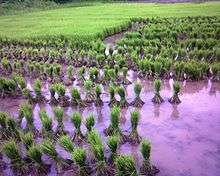
Karumallur(ml:കരുമാല്ലൂർ) is a village in Paravur Taluk, Ernakulam district in the Indian state of Kerala.[1]Karumalloor (Karumalore) is a panchayat in Ernakulam District.[2] Karumalloor is situated in the highway connecting North Paravur with Aluva. This road is a nationalized route of KSRTC and plenty of buses connecting North Paravur with eastern parts of Ernakulam District are running. It is situated 6 kilometers from Paravur. The village consists of large tracts of paddy fields. Karumallur is bounded by distributaries of the river Periyar. The panchayat is mainly a rice-based agrarian economy.
History
Karumallur was under Ayirur village union . The panchayat was formed in 1953. The village was famous for agricultural tools and even people from north come to buy these products.
Demographics
As of 2001 India census, Karumalloor had a population of 26858 with 13189 males and 13669 females.[1]
Educational Organizations
- U.C College
- Holy Matha College, Manakkapady
- SNGIST, Thekkethazham
- Thantric Vidyapeedom
- The Alwaye Settlement H.S.School
- K.E.M.H.S., Kottapuram
- FMCT HS, Manakkapady
- MIUP School Veliyathunadu
Localities
U.C College, Veliyathunad, Parana, Aduvathuruth, Karumallur, Mattupuram, Manjaly, Kallikuzhy, Manakkapady, Thattampady, Millupadi, Kaduvappadam, Mariyapady,Paruvakkad, Vayalodam, Chettikkad, Thekkethazham, Karukunnu
Roads
- Parur - Kothamangalam road
- UC College – Veliyathunad/Thadikkakadav road
Ferrys
- Mambra - Wayalkara
- Mattupuram - Chowkakadav
Places of worship
- Purapillikavu Bhagavathy temple ,Karumalloor
- St.Joseph's Church, Manakkappady
- St.Thomas Church, Thattampady, Karumallur
- W.Veliyathunadu Jum'a Masjid
- E.Veliyathunadu Jum'a Masjid
- Kaduvapadam Jum'a Masjid
- Badriya Masjid,Aduvathuruth
- Karipuram Sreekrishna temple
- Narayanamangalam Dharmashastha Temple
- Alangadu Jum'a Masjid
See also
References
- 1 2 "Census of India : Villages with population 5000 & above". Retrieved 2008-12-10.
|first1=missing|last1=in Authors list (help) - ↑ "Panchayats - Ernakulam District". National Informatics Centre. Retrieved 30 January 2010.