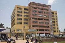
Kawempe General Hospital
| Kawempe General Hospital | |
|---|---|
|
Uganda Ministry of Health and Kampala Capital City Authority | |
| Geography | |
| Location | Kawempe, Kampala, Central Region, Uganda |
| Organisation | |
| Care system | Public |
| Hospital type | General |
| Services | |
| Emergency department | III |
| Beds | 170 |
| History | |
| Founded | 2016 [1] |
| Links | |
| Lists | Hospitals in Uganda |
| Other links | Hospitals in Uganda |
Kawempe General Hospital, also known as the Kawempe General Referral Hospital, is a hospital in Uganda, the third-largest economy in the East African Community. It is an urban, general hospital built between 2014 and 2016, at an estimated cost of US$15 million (UGX:38 billion). The hospital was constructed by the government of Uganda, with funding from the African Development Bank and the Nigeria Trust Fund.[2]
Location
The hospital is in Kawempe Division, one of the five administrative units of the Kampala Capital City Authority. This location is approximately 12 kilometres (7.5 mi), by road, north of the city's central business district, along the Kampala-Gulu Highway.[3] The coordinates of the hospital are 0°21'43.0"N, 32°33'41.0"E (Latitude:0.361944; Longitude:32.561389).[4]
Overview
In December 2013, the Uganda Government, through the Ministry of Health, contracted China National Aero Technology to construct the hospital at an estimated cost of approximately US$15 million (UGX:38 billion). Construction is expected to commence in 2014.[5] In December 2015, Ugandan print media reported that construction of the hospital was nearing completion, with commissioning planned for March 2016.[1]
Target population
Due to rapid urbanization, the night-time population of Kampala, Uganda's capital and largest city, is estimated at 2 million, but swells to 4.5 million during the day.[6] This huge increase in the city's population has outstripped the services delivery facilities and mechanisms established by the British colonialists during the mid 1900s. Extreme pressure has been exerted, particularly on Mulago National Referral Hospital, the largest public hospital in the country, which also serves as the teaching hospital for Makerere University College of Health Sciences.
In 2013, the Uganda government obtained a loan from the African Development Bank and Nigeria Trust Fund to (a) rehabilitate and improve Mulago Hospital (b) construct Kawempe General Referral Hospital (c) construct Kiruddu General Referral Hospital and (d) re-organize healthcare delivery in the city of Kampala, so that some of the patient burden is shifted to Naguru General Hospital, Kawempe General Hospital, and Kiruddu General Hospital. Mulago will then be reserved for the role for which it was constructed; as a true referral hospital, serving patients referred to it by other health facilities, and not handing common colds and uncomplicated ear infections.[7][8]
See also
References
- 1 2 "KCCA Kawempe, Kiruddu hospitals construction near completion". New Vision. Kampala. 19 December 2015. Retrieved 19 December 2015.
- ↑ Wacha, Joe (14 May 2013). "Government Moves To Construct Referral Hospitals In Kawempe, Makindye". Uganda Radio Network. Retrieved 11 October 2014.
- ↑ "Travel Distance Between Central Kampala And Kawempe With Map". Globefeed.com. Retrieved 11 October 2014.
- ↑ Google (19 December 2015). "Location of Kawempe General Hospital" (Map). Google Maps. Google. Retrieved 19 December 2015.
- ↑ AfDB (27 June 2013). "Improvement of Health Services Delivery At Mulago Hospital And The City of Kampala Project (MKCCAP)" (PDF). African Development Bank (AfDB). Retrieved 11 October 2014.
- ↑ Namuli, Zahra (4 December 2013). "Government To Construct More Referral Hospitals". Kampala: National Broadcasting Service (NBS). Retrieved 11 October 2014.
- ↑ Ayebazibwe, Agatha (11 October 2014). "Mulago Hospital Renovation Starts". Daily Monitor. Kampala. Retrieved 11 October 2014.
- ↑ Zurah Nakabugo, and Racheal Ninsiima (4 April 2016). "Uganda: Mulago Patient Transfers Begin". The Observer (Uganda) via AllAfrica.com. Kampala. Retrieved 18 June 2016.
External links

Coordinates: 00°21′43″N 32°33′41″E / 0.36194°N 32.56139°E