Kemerovsky District
| Kemerovsky District Кемеровский район (Russian) | |
|---|---|
.svg.png) Location of Kemerovsky District in Kemerovo Oblast | |
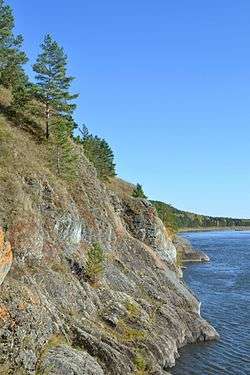 Painted Preserve, Tom River | |
.png) | |
|
| |
| Location | |
| Country | Russia |
| Federal subject | Kemerovo Oblast[1] |
| Administrative structure (as of November 2012) | |
| Administrative center | city of Kemerovo[1] |
| Administrative divisions:[1] | |
| rural territorie | 9 |
| Inhabited localities:[1] | |
| Rural localities | 71 |
| Municipal structure (as of November 2012) | |
| Municipally incorporated as | Kemerovsky Municipal District[2] |
| Municipal divisions:[2] | |
| Urban settlements | 0 |
| Rural settlements | 9 |
| Statistics | |
| Area | 4,391 km2 (1,695 sq mi)[3] |
| Population (2010 Census) | 45,459 inhabitants[4] |
| • Urban | 0% |
| • Rural | 100% |
| Density | 10.35/km2 (26.8/sq mi)[5] |
| Time zone | KRAT (UTC+07:00)[6] |
| Official website | |
| Kemerovsky District on WikiCommons | |
Kemerovsky District (Russian: Ке́меровский райо́н) is an administrative district (raion), one of the nineteen in Kemerovo Oblast, Russia.[1] As a municipal division, it is incorporated as Kemerovsky Municipal District.[2] It is located in the northern central portion of the oblast. The area of the district is 4,391 square kilometers (1,695 sq mi).[3] Its administrative center is the city of Kemerovo (which is not administratively a part of the district).[1] Population: 45,459 (2010 Census);[4] 39,036 (2002 Census);[7] 37,207 (1989 Census).[8]
Geography
Kemerovsky District is in the northwest of the Kuznetsk Depression, which is the basin of the Tom River between the Salair Ridge to the west, and the Kuznetsky Alatau mountains to the east. The district surrounds the urban city district of Kemerovo, and features a stretch of the Tom River running southeast-to-northwest through the middle. The district covers a rich portion of the Kuznetsk Basin (the "Kuzbass" coal region).[9] The district is 150 km north of the Novokuznetsk. The terrain is a steeply sloping, hilly plain. Vegetation is northern steppe forest, with about 20% of the area steppe.[10]
The district is about 100 km north-to-south, and 75 km west-to-east. Kemerovsky is about 200 km east of the city of Novosibirsk, and the M53 ("Novosibirsk - Krasnoyarsk") highway runs through the district. Subdivisions of the district include 9 rural settlements.[11] The climate of the district is humid continental (Koppen Dfb).
Kemorovsky District borders Krapivinsky District to the south, Izhmorsky District, Chebulinsky District, and Tisulsky District to the east, Topkinsky District to the west, and Yaysky District and Yashkinsky District to the north.
Administrative and municipal status
Within the framework of administrative divisions, Kemerovsky District is one of the nineteen in the oblast.[1] The city of Kemerovo serves as its administrative center, despite being incorporated separately as a city under oblast jurisdiction—an administrative unit with the status equal to that of the districts.[1]
As a municipal division, the district is incorporated as Kemerovsky Municipal District.[2] Kemerovo City Under Oblast Jurisdiction is incorporated separately from the district as Kemerovsky Urban Okrug.[2]
References
- 1 2 3 4 5 6 7 8 Law #215-OZ
- 1 2 3 4 5 Law #104-OZ
- 1 2 "Area - Kemerov District'" (in Russian). Kemorov District (Official Web Site). Retrieved June 26, 2016.
- 1 2 Russian Federal State Statistics Service (2011). "Всероссийская перепись населения 2010 года. Том 1" [2010 All-Russian Population Census, vol. 1]. Всероссийская перепись населения 2010 года (2010 All-Russia Population Census) (in Russian). Federal State Statistics Service. Retrieved June 29, 2012.
- ↑ The value of density was calculated automatically by dividing the 2010 Census population by the area specified in the infobox. Please note that this value is only approximate as the area specified in the infobox does not necessarily correspond to the area of the entity proper or is reported for the same year as the population.
- ↑ Правительство Российской Федерации. Федеральный закон №107-ФЗ от 3 июня 2011 г. «Об исчислении времени», в ред. Федерального закона №271-ФЗ от 03 июля 2016 г. «О внесении изменений в Федеральный закон "Об исчислении времени"». Вступил в силу по истечении шестидесяти дней после дня официального опубликования (6 августа 2011 г.). Опубликован: "Российская газета", №120, 6 июня 2011 г. (Government of the Russian Federation. Federal Law #107-FZ of June 31, 2011 On Calculating Time, as amended by the Federal Law #271-FZ of July 03, 2016 On Amending Federal Law "On Calculating Time". Effective as of after sixty days following the day of the official publication.).
- ↑ Russian Federal State Statistics Service (May 21, 2004). "Численность населения России, субъектов Российской Федерации в составе федеральных округов, районов, городских поселений, сельских населённых пунктов – районных центров и сельских населённых пунктов с населением 3 тысячи и более человек" [Population of Russia, Its Federal Districts, Federal Subjects, Districts, Urban Localities, Rural Localities—Administrative Centers, and Rural Localities with Population of Over 3,000] (XLS). Всероссийская перепись населения 2002 года [All-Russia Population Census of 2002] (in Russian). Retrieved August 9, 2014.
- ↑ Demoscope Weekly (1989). "Всесоюзная перепись населения 1989 г. Численность наличного населения союзных и автономных республик, автономных областей и округов, краёв, областей, районов, городских поселений и сёл-райцентров" [All Union Population Census of 1989: Present Population of Union and Autonomous Republics, Autonomous Oblasts and Okrugs, Krais, Oblasts, Districts, Urban Settlements, and Villages Serving as District Administrative Centers]. Всесоюзная перепись населения 1989 года [All-Union Population Census of 1989] (in Russian). Институт демографии Национального исследовательского университета: Высшая школа экономики [Institute of Demography at the National Research University: Higher School of Economics]. Retrieved August 9, 2014.
- ↑ "Kuznetsk Coal Basin - Map". Russian Coal. Independent analytical agency "Rosinformugol". Retrieved 2 July 2016.
- ↑ "About the region - climate and environment". Kemerovsky District (Official website). Kemerovsky District. Retrieved 3 July 2016.
- ↑ "State - General Information" (in Russian). Izhmorsky District (Official Website). Retrieved July 2, 2016.
Sources
- Совет народных депутатов Кемеровской области. Закон №215-ОЗ от 27 декабря 2007 г. «Об административно-территориальном устройстве Кемеровской области», в ред. Закона №131-ОЗ от 22 декабря 2014 г. «О внесении изменений в Закон Кемеровской области "О статусе и границах муниципальных образований" и Закон Кемеровской области "Об административно-территориальном устройстве Кемеровской области"». Вступил в силу в день, следующий за днём официального опубликования. Опубликован: "Кузбасс", №243, 28 декабря 2007 г. (Council of People's Deputies of Kemerovo Oblast. Law #215-OZ of December 27, 2007 On the Administrative-Territorial Structure of Kemerovo Oblast, as amended by the Law #131-OZ of December 22, 2014 On Amending the Law of Kemerovo Oblast "On the Status and the Borders of the Municipal Formations" and the Law of Kemerovo Oblast "On the Administrative-Territorial Structure of Kemerovo Oblast". Effective as of the day following the official publication date.).
- Совет народных депутатов Кемеровской области. Закон №104-ОЗ от 17 декабря 2004 г. «О статусе и границах муниципальных образований», в ред. Закона №123-ОЗ от 22 декабря 2015 г. «О внесении изменений в Закон Кемеровской области "О статусе и границах муниципальных образований"». Вступил в силу со дня официального опубликования. Опубликован: "Кузбасс", №242, 24 декабря 2004 г. (Council of People's Deputies of Chelyabinsk Oblast. Law #104-OZ of December 17, 2004 On the Status and the Borders of the Municipal Formations, as amended by the Law #123-OZ of December 22, 2015 On Amending the Law of Kemerovo Oblast "On the Status and the Borders of the Municipal Formations". Effective as of the official publication date.).
External links
| Cities and towns | ||
|---|---|---|
| Urban-type settlements under oblast jurisdiction | ||
| Administrative districts | ||
Coordinates: 55°20′00″N 86°04′00″E / 55.3333°N 86.0667°E