Tisulsky District
| Tisulsky District Тисульский район (Russian) | |
|---|---|
.svg.png) Location of Tisulsky District in Kemerovo Oblast | |
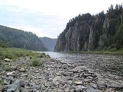 The Kiya River near the settlement of Moskovka in Tisulsky District | |
.png) |
.png) |
|
| |
| Location | |
| Country | Russia |
| Federal subject | Kemerovo Oblast[1] |
| Administrative structure (as of November 2012) | |
| Administrative center | urban-type settlement of Tisul[1] |
| Administrative divisions:[1] | |
| Urban-type settlements | 3 |
| Rural territories | 10 |
| Inhabited localities:[1] | |
| Urban-type settlements[2] | 3 |
| Rural localities | 34 |
| Municipal structure (as of November 2012) | |
| Municipally incorporated as | Tisulsky Municipal District[3] |
| Municipal divisions:[3] | |
| Urban settlements | 3 |
| Rural settlements | 10 |
| Statistics | |
| Area | 8,100 km2 (3,100 sq mi)[4] |
| Population (2010 Census) | 25,045 inhabitants[5] |
| • Urban | 58.4% |
| • Rural | 41.6% |
| Density | 3.09/km2 (8.0/sq mi)[6] |
| Time zone | KRAT (UTC+07:00)[7] |
| Official website | |
| Tisulsky District on WikiCommons | |
Tisulsky District (Russian: Тисульский райо́н) is an administrative district (raion), one of the nineteen in Kemerovo Oblast, Russia.[1] As a municipal division, it is incorporated as Tisulsky Municipal District.[3] It is located in the east of the oblast. The area of the district is 8,100 square kilometers (3,100 sq mi).[4] Its administrative center is the urban locality (an urban-type settlement) of Tisul.[1] Population: 25,045 (2010 Census);[5] 28,471 (2002 Census);[8] 34,707 (1989 Census).[9] The population of Tisul accounts for 36.1% of the district's total population.[5]
Geography
The district is in the northeast of Kemerovo Oblast, and the Kuznetsk Basin, and covers the northern end of the Kuznetsk Alatau mountain range. The Kuznetsk Alatau is the source of many rivers and streams that flow north to the Kiya River, and eventually the Tom River.Much of the terrain is mid-height mountains, with the southern portion of the district being part of a federally protected area, the Kuznetsk Alatau Nature Reserve. Vegetation is mostly dark taiga (coniferous forest).The district is about 250 km east of the regional city of Kemerovo. [10]
Tisulsky District borders with Tyazhinsky District in the north, Krapivinsky District in the south, and with Chebulinsky District in the west.
References
- 1 2 3 4 5 6 Law #215-OZ
- ↑ The count of urban-type settlements may include the work settlements, the resort settlements, the suburban (dacha) settlements, as well as urban-type settlements proper.
- 1 2 3 Law #104-OZ
- 1 2 "Tisulsky District" (in Russian). Tisulsky District (Official Website). Retrieved June 26, 2016.
- 1 2 3 Russian Federal State Statistics Service (2011). "Всероссийская перепись населения 2010 года. Том 1" [2010 All-Russian Population Census, vol. 1]. Всероссийская перепись населения 2010 года (2010 All-Russia Population Census) (in Russian). Federal State Statistics Service. Retrieved June 29, 2012.
- ↑ The value of density was calculated automatically by dividing the 2010 Census population by the area specified in the infobox. Please note that this value is only approximate as the area specified in the infobox does not necessarily correspond to the area of the entity proper or is reported for the same year as the population.
- ↑ Правительство Российской Федерации. Федеральный закон №107-ФЗ от 3 июня 2011 г. «Об исчислении времени», в ред. Федерального закона №271-ФЗ от 03 июля 2016 г. «О внесении изменений в Федеральный закон "Об исчислении времени"». Вступил в силу по истечении шестидесяти дней после дня официального опубликования (6 августа 2011 г.). Опубликован: "Российская газета", №120, 6 июня 2011 г. (Government of the Russian Federation. Federal Law #107-FZ of June 31, 2011 On Calculating Time, as amended by the Federal Law #271-FZ of July 03, 2016 On Amending Federal Law "On Calculating Time". Effective as of after sixty days following the day of the official publication.).
- ↑ Russian Federal State Statistics Service (May 21, 2004). "Численность населения России, субъектов Российской Федерации в составе федеральных округов, районов, городских поселений, сельских населённых пунктов – районных центров и сельских населённых пунктов с населением 3 тысячи и более человек" [Population of Russia, Its Federal Districts, Federal Subjects, Districts, Urban Localities, Rural Localities—Administrative Centers, and Rural Localities with Population of Over 3,000] (XLS). Всероссийская перепись населения 2002 года [All-Russia Population Census of 2002] (in Russian). Retrieved August 9, 2014.
- ↑ Demoscope Weekly (1989). "Всесоюзная перепись населения 1989 г. Численность наличного населения союзных и автономных республик, автономных областей и округов, краёв, областей, районов, городских поселений и сёл-райцентров" [All Union Population Census of 1989: Present Population of Union and Autonomous Republics, Autonomous Oblasts and Okrugs, Krais, Oblasts, Districts, Urban Settlements, and Villages Serving as District Administrative Centers]. Всесоюзная перепись населения 1989 года [All-Union Population Census of 1989] (in Russian). Институт демографии Национального исследовательского университета: Высшая школа экономики [Institute of Demography at the National Research University: Higher School of Economics]. Retrieved August 9, 2014.
- ↑ "Tisulsky District" (in Russian). Tisulsky District (Official Website). Retrieved June 27, 2016.
Sources
- Совет народных депутатов Кемеровской области. Закон №215-ОЗ от 27 декабря 2007 г. «Об административно-территориальном устройстве Кемеровской области», в ред. Закона №131-ОЗ от 22 декабря 2014 г. «О внесении изменений в Закон Кемеровской области "О статусе и границах муниципальных образований" и Закон Кемеровской области "Об административно-территориальном устройстве Кемеровской области"». Вступил в силу в день, следующий за днём официального опубликования. Опубликован: "Кузбасс", №243, 28 декабря 2007 г. (Council of People's Deputies of Kemerovo Oblast. Law #215-OZ of December 27, 2007 On the Administrative-Territorial Structure of Kemerovo Oblast, as amended by the Law #131-OZ of December 22, 2014 On Amending the Law of Kemerovo Oblast "On the Status and the Borders of the Municipal Formations" and the Law of Kemerovo Oblast "On the Administrative-Territorial Structure of Kemerovo Oblast". Effective as of the day following the official publication date.).
- Совет народных депутатов Кемеровской области. Закон №104-ОЗ от 17 декабря 2004 г. «О статусе и границах муниципальных образований», в ред. Закона №123-ОЗ от 22 декабря 2015 г. «О внесении изменений в Закон Кемеровской области "О статусе и границах муниципальных образований"». Вступил в силу со дня официального опубликования. Опубликован: "Кузбасс", №242, 24 декабря 2004 г. (Council of People's Deputies of Chelyabinsk Oblast. Law #104-OZ of December 17, 2004 On the Status and the Borders of the Municipal Formations, as amended by the Law #123-OZ of December 22, 2015 On Amending the Law of Kemerovo Oblast "On the Status and the Borders of the Municipal Formations". Effective as of the official publication date.).
| Cities and towns | ||
|---|---|---|
| Urban-type settlements under oblast jurisdiction | ||
| Administrative districts | ||
Coordinates: 55°45′43″N 88°18′55″E / 55.76194°N 88.31528°E