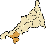
Kerrier Hundred
Coordinates: 50°06′22″N 5°16′12″W / 50.106°N 5.270°W
| Kerrier Hundred | |
|---|---|
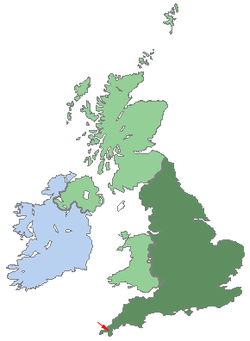  Shown within UK |
The hundred of Kerrier was the name of one of ten ancient administrative shires of Cornwall, in the United Kingdom. Kerrier (sometimes Kirrier) is thought by Charles Thomas to be derived from an obsolete name (ker hyr = long fort) of Castle Pencaire on Tregonning Hill, Breage.[1] It is likely that an even earlier name for the district was Predannack which has been displaced by the Lizard Peninsula as a geographical name.
Parishes in Kerrier hundred
St Anthony-in-Meneage, Breage, Budock, Constantine, Cury, Falmouth, Germoe, St Gluvias, Grade, Gunwalloe alias Winnington, Gwennap with St Day, Helston, St Keverne, Landewednack, Mabe, Manaccan, St Martin-in-Meneage, Mawgan-in-Meneage, Mawnan, Mullion, Mylor, Perranarworthal, Ruan Minor, and Ruan Major, Sithney, St Stithians, Wendron
Adjacent hundreds
- Penwith Hundred (northwest)
- Pydarshire Hundred (north)
- Powdershire Hundred (northeast)
 |
Penwith Hundred | Pydarshire Hundred | Powdershire Hundred | |
| Penwith Hundred | |
Atlantic Ocean | ||
| ||||
| | ||||
| Atlantic Ocean | Atlantic Ocean | Atlantic Ocean |
References
- ↑ Thomas, Charles (1964) Settlement History in Early Cornwall: I; the antiquity of the hundreds (In: Cornish Archaeology. 3. St Ives: Cornwall Archaeological Society, pp. 70-79)
External links
Cornwall Portal | |
| Unitary authorities | |
| Major settlements |
|
| Rivers | |
| Topics | |