Kew Railway Bridge
| Kew Railway Bridge | |
|---|---|
 Kew Railway Bridge | |
| Carries |
North London Line of the London Overground London Underground District line |
| Crosses | River Thames |
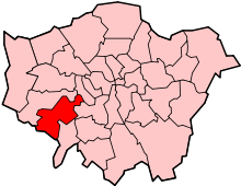
| Locale | Kew |
| Maintained by | Network Rail |
| Heritage status | Grade II listed structure[1] |
| Characteristics | |
| Design | Lattice girder[1] |
| Material | Wrought iron |
| Total length | 575 feet |
| Number of spans | 5 |
| History | |
| Designer | W. R. Galbraith[2][1] |
| Opened | 1869[1] |
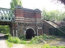
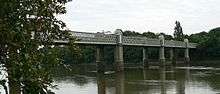
Kew Railway Bridge (or Strand-on-the-Green Bridge) spans the River Thames in London, England, between Kew and Strand-on-the-Green, Chiswick. The bridge, which was given Grade II listed structure protection in 1983,[1] was designed by W. R. Galbraith[2] and built by Brassey & Ogilvie for the London and South Western Railway. The bridge is part of an extension to the latter company's railway line from Acton Junction to Richmond. The bridge was opened in 1869[1] and consists of five wrought iron lattice girder spans of 35 metres each. The cast iron piers are decorated in three stages. During the second world war a pillbox was built to guard it on the south end, along with an open enclosure to fire an anti-tank gun from.
The bridge carries two tracks which are electrified with both third rail and London Underground-style fourth rail. It is now owned by Network Rail and used by London Overground for North London Line passenger trains running between Richmond and Stratford. The same tracks are also used by London Underground's District line trains running between Richmond and Upminster.
In fiction
In The Dalek Invasion of Earth, a 1964 serial from the BBC's Doctor Who, the TARDIS materialises under Kew Railway Bridge, where it is subsequently trapped when the bridge collapses.[3]
See also
References
- 1 2 3 4 5 6 Historic England. "Details from image database (205514)". Images of England. accessed 27 November 2008
- 1 2 Bridget Cherry and Nikolaus Pevsner (1983). The Buildings of England – London 2: South. London: Penguin Books. p. 715. ISBN 0 14 0710 47 7.
- ↑ "Kew Railway Bridge". Drwholocations.net. Retrieved 6 March 2013.
External links
-
 Media related to Kew Railway Bridge at Wikimedia Commons
Coordinates: 51°29′02″N 0°16′46″W / 51.48389°N 0.27944°W
| |||||||||||||||||||||||||||||||||