Khomarlu
| Khomarlu خمارلو | |
|---|---|
| city | |
|
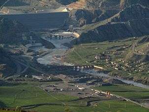
Khoda Afarin Bridges in the background of Khoda Afarin dam | |
 Khomarlu | |
| Coordinates: 39°08′56″N 47°02′05″E / 39.14889°N 47.03472°ECoordinates: 39°08′56″N 47°02′05″E / 39.14889°N 47.03472°E | |
| Country |
|
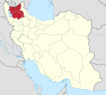
| Province | East Azerbaijan |
| County | Khoda Afarin |
| Bakhsh | Central |
| Population (2006) | |
| • Total | 1,222 |
| Time zone | IRST (UTC+3:30) |
| • Summer (DST) | IRDT (UTC+4:30) |
Khomarlu (Persian: خمارلو; also Romanized as Khomārlū)[1] is a city in and the capital of Khoda Afarin County, East Azerbaijan Province, Iran. At the 2006 census, its population was 1,222, in 334 families.[2]
Situation
The first reference to Khomarlu in the published literature, is the following description by Robert Mignan, "..the village of Khomorloo, situated upon a deep ravine, between steep calcareous and barren mountains. The dwellings of the villagers were scooped from the sides of a mountain, which formed three sides of each hut, the fourth being a wall of mud, in which an aperture of four feet square was left, and a few miserable planks tied together served for the door: the whole covered over by rafters, and a thin coating of flat thatch. They had the character of being plunderers and assassins, but excused their depredations by pretending that the whole country were at war with them. Had we not been with the prince, we dared not have trusted to their hospitality. They appeared the poorest people we had yet seen. Both sexes were clad in rags, and the children to the age of seven were tous nude. They possessed a few sheep and goats, and a good supply of grapes, which they had preserved all the winter...".[3]
Online edition of the Dehkhoda Dictionary, quoting Iranian Army files,[4] reports a population of 396 people in late 1940s.[5] The village was infamous for having a branch of Royal Gendarme, which was tasked with conscripting soldiers. In the wake of White Revolution (early 1960s) a clan of Mohammad Khanlu tribe, comprising 60 households, used Khomarlu as their winter quarters.[6]
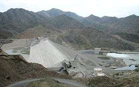
Just after the revolution, revolutionary institutions, such as Friday Prayer office, were set office in the village. In 1988 the notary branch of the district moved from Abbasabad to Khomarlu and added to the importance of the village. In 1999, Khomarlu was declared a town by the decree of central government.[7] The construction of Khoda Afarin Dam in the vicinity of the village was a turning point in the development of the village and transforming it to a town.
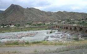
The most important landmark near the town is a pair of historical bridges, known as Khoda Afarin Bridges. One bridge is in ruins but the other with a length of 160 m is still usable by pedestrians.
References
- ↑ Khomarlu can be found at GEOnet Names Server, at this link, by opening the Advanced Search box, entering "-3071131" in the "Unique Feature Id" form, and clicking on "Search Database".
- ↑ "Census of the Islamic Republic of Iran, 1385 (2006)". Islamic Republic of Iran. Archived from the original (Excel) on 2011-11-11.
- ↑ Robert Mignan, A Winter Journey Through Russia, the Caucasian Alps, and Georgia: Thence ..., Vol. 1, 1839, London, p. 130
- ↑ فرهنگ جغرافیایی ایران، آبادیها، زیر نظر حسینعلی رزم آرا، تهران: سازمان جغرافیایی کشور، 1329، ج 4
- ↑ http://www.loghatnaameh.org/dehkhodaworddetail-788eb09b6f0846ce8227ba2a4d071158-fa.html
- ↑ P. Oberling, “The Tribes of Qarāca Dāġ,” Oriens 17, 1964, p. 69
- ↑ http://rc.majlis.ir/fa/law/show/118514
| Capital | |||||||||||||||||||||||||||||||||||||||||||||||
|---|---|---|---|---|---|---|---|---|---|---|---|---|---|---|---|---|---|---|---|---|---|---|---|---|---|---|---|---|---|---|---|---|---|---|---|---|---|---|---|---|---|---|---|---|---|---|---|
| Districts |
| ||||||||||||||||||||||||||||||||||||||||||||||