Kii Peninsula
| Kii Peninsula (紀伊半島, Kii-hantō) | |
| peninsula | |
 | |
| Country | Japan |
|---|---|
| State | Wakayama Prefecture, Mie Prefecture, Osaka Prefecture, Nara Prefecture[1] |
| Region | Kansai Region |
| River | Kinokawa River, Kushida River |
| Highest point | |
| - coordinates | JP 34°18′10″N 135°57′18″E / 34.30278°N 135.95500°E |
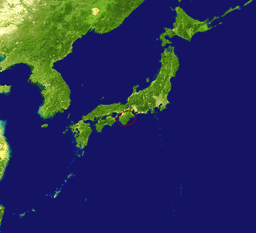 Location of the Kii Peninsula in Japan | |
The Kii Peninsula (紀伊半島 Kii Hantō) is the largest peninsula on the island of Honshū in Japan.[2] It is named after the ancient Kii Province.
The area south of the “Central Tectonic Line” is called Nanki (南紀), and includes the most poleward living coral reefs in the world due to the presence of the warm Kuroshio Current, though these are threatened by global warming and human interference. Because of the Kuroshio’s strong influence, the climate of Nankii is the wettest in the Earth’s subtropics with rainfall in the southern mountains believed to reach 5 metres (200 in) per year and in the southeastern town of Owase it averages 3.85 metres (151.6 in), comparable to Ketchikan, Alaska or Tortel in southern Chile. When typhoons hit Japan the Kii Peninsula is typically the worst affected area and daily rainfalls as high as 940 millimetres (37 in) are not unknown.
Most of the Kii Peninsula is dense temperate rainforest since the climate even in the very limited lowlands is too wet for agriculture, and much of the coast consists of networks of small rias into which flow very steep and rapid streams characterised by a large number of high waterfalls. Forestry and fishing were the traditional economic mainstays of the region and remain important even today despite a declining population and labour force.[3]
Location
Wakayama Prefecture occupies much of the area, including the entire southern part. To the northwest of Wakayama Prefecture is Osaka Prefecture, whose southern part is on the peninsula. East of Osaka Prefecture is landlocked Nara Prefecture; farther east is Mie Prefecture.
The Seto Inland Sea lies to the west of the Kii Peninsula. To the south and east is the Pacific Ocean and to the north is the valley of the Kiso Three Rivers and Ise Bay.
Notable places
Notable places in the Kii Peninsula include :
- Nara, former capital of Japan.
- Mount Koya (or Kōyasan), the headquarters of the Shingon sect of Buddhism.
- Wakayama, former home of the Kii (or Kishu) Tokugawa clan. It is the location of the Hinokuma Shrine that is pursuant to Grand Shrine of Ise.
- Matsuzaka, now the center of a major beef-producing area, formerly the center of Ise merchants.
- Ise, the location of the Grand Shrine of Ise and center of pearl production.
- Yoshino District, a wild area of heavily forested deep mountains, home of the Southern Imperial Court during the Nanboku-chō period of Japanese history.
- Kumano Region, home of the Kumano Shrines and the Nachi Waterfall. Another name is Muro District.
- Kushimoto, Wakayama, the southernmost point in Honshū.
- Taiji, Wakayama, the birthplace of the Japanese traditional whaling.
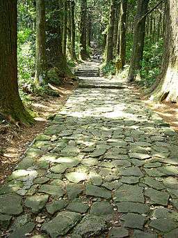
The Kii Peninsula is the location of a UNESCO World Heritage Site: Sacred Sites and Pilgrimage Routes in the Kii Mountain Range.[4]
In 2004, UNESCO designated three other locations on the Kii Peninsula as World Heritage Sites. They are:
- Yoshino and Mount Omine, mountainous areas in the north of the peninsula.
- Kumano Shrines, three shrines at the southern tip of the peninsula.
- Mount Koya, the mountain at the west of the peninsula
Transportation
- Nanki-Shirahama Airport in Shirahama serves the southern part of the Kii Peninsula.
- Kisei Main Line connects Wakayama to Mie Prefecture and runs along the peninsula's coastline.
Notes
External links
| Wikimedia Commons has media related to Kii Peninsula. |
Coordinates: 34°18′10″N 135°57′18″E / 34.30278°N 135.95500°E