Kikorongo–Ishaka Road
| Kikorongo–Ishaka Road | |
|---|---|
| Route information | |
| Length: | 45 mi (72 km) |
| Major junctions | |
| North end: | Kikorongo |
|
Katunguru Rubirizi | |
| South end: | Ishaka |
| Highway system | |
| Roads in Uganda | |
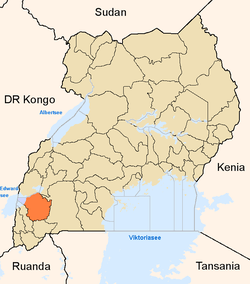
Kikorongo–Ishaka Road is a road in the Western Region of Uganda, connecting the towns of Kikorongo in Kasese District with Ishaka in Bushenyi District.
Location
This road starts at Kikorongo, on the Fort Portal–Kasese–Mpondwe Road. It proceeds southward across the Kazinga Channel at Katunguru, continuing through Rubirizi, to end at Ishaka, a total distance of about 73 kilometres (45 mi).[1] The coordinates of the road near Rubirizi are 0°16'37.0"S, 30°06'27.0"E (Latitude:-0.276949; Longitude:30.107488).[2]
Overview
This road is an important transport corridor for people and goods from Rwanda, Burundi and the Western Region of Uganda, destined for South Sudan.[3] The section between Ishaka and Katunguru, measuring about 55 kilometres (34 mi)[4] was rehabilitated between August 1990 and July 1993 by China Sichuan International Cooperation Company Limited (SIETCO), at a cost of US$13.8 million, borrowed from the African Development Bank.[5]
See also
References
- ↑ GFC (21 May 2016). "Distance between Kikorongo Junction, Fort Portal-Mpondwe Road, Kasese, Western Region, Uganda and Ishaka, Western Region, Uganda". Globefeed.com (GFC). Retrieved 21 May 2016.
- ↑ Google (21 May 2016). "Location of Kikorongo–Ishaka Road" (Map). Google Maps. Google. Retrieved 21 May 2016.
- ↑ Kron, Josh (6 July 2011). "As It Emerges as a Nation, South Sudan Extends the Clout of Its Neighbor Uganda". The New York Times. New York City. Retrieved 21 May 2016.
- ↑ GFC (21 May 2016). "Distance between Good Times Restaurant, Ntungamo-Katunguru Road, Ishaka, Western Region, Uganda and Katunguru, Western Region, Uganda". Globefeed.com (GFC). Retrieved 21 May 2016.
- ↑ AfDB (December 1994). "African Development Fund: Project Completion Report - Rehabilitation of the Ishaka-Katunguru Road, Uganda" (PDF). Abidjan: African Development Bank (AfDB). Retrieved 21 May 2016.
External links
Capital: Kasese | ||
| Towns and villages | ||
| Economy |
| |
| Transport | ||
| Energy | ||
| Notable landmarks | ||
| Health | ||
| Notable people | ||
Capital: Rubirizi | |
| Counties and sub-counties |
|
| Towns and villages | |
| Geography | |
| Economy |
|
| Transport | |
| Notable landmarks |
|
| Notable people | |
Capital: Bushenyi | ||
| Counties and sub-counties |
|  |
| Parishes |
| |
| Towns and villages | ||
| Economy | ||
| Education | ||
| Health | ||
| Transport | ||
| Notable people | ||
Coordinates: 00°16′37″S 30°06′27″E / 0.27694°S 30.10750°E