Kilsyth
| Kilsyth | |
| Scottish Gaelic: Cill Saidhe | |
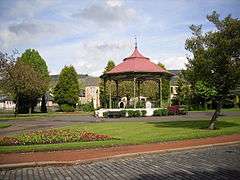 The bandstand in Burngreen, Kilsyth |
|
 Kilsyth |
|
| Population | 10,100 (2004 Estimates) |
|---|---|
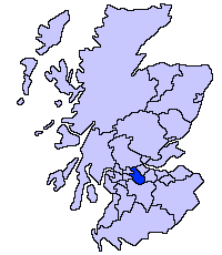
| Council area | North Lanarkshire |
| Lieutenancy area | Dunbartonshire |
| Country | Scotland |
| Sovereign state | United Kingdom |
| Post town | GLASGOW |
| Postcode district | G65 |
| Dialling code | 01236 |
| Police | Scottish |
| Fire | Scottish |
| Ambulance | Scottish |
| EU Parliament | Scotland |
| UK Parliament | Cumbernauld, Kilsyth and Kirkintilloch East |
| Scottish Parliament | Cumbernauld and Kilsyth |
Coordinates: 55°59′N 4°04′W / 55.98°N 4.06°W
Kilsyth (/kɪlˈsaɪθ/; Scottish Gaelic Cill Saidhe) is a town and civil parish in North Lanarkshire of 10,100 (2004 Estimates) roughly halfway between Glasgow and Stirling in Scotland.
Location
Kilsyth is at 60 metres (200 ft) above sea level and occupies a narrow strip of land between the Kilsyth Hills to the north and the River Kelvin to the south. To the east and west it is bordered by marshland and bogs. The centre of the town is close to the confluence of the Garrell and Ebroch burns.

From earliest recorded times Kilsyth was one of the main routes between Glasgow, Falkirk and Edinburgh, and is very close to the Roman Antonine Wall, the Forth and Clyde Canal and the main Glasgow to Edinburgh railway line, with the nearest railway station at Croy. The main A80/M80 motorway is close by to the south. Formerly two separate stations existed in the town on separate, although linked, railway lines. One, The Kelvin Valley Railway went to Glasgow, Maryhill while the other, the Kilsyth and Bonnybridge railway went via Banknock to Falkirk. The town occupies a sheltered position in the Kelvin Valley, and is bisected by the A803 between Kirkintilloch and Falkirk. The old drovers' road from Stirling, (the Tak Ma Doon Road), and the route south to Cumbernauld via Auchinstarry Bridge, intersect the A803 at Kilsyth.
History and development
There is archeological evidence of settlement since Neolithic times[1] The Romans recognised the strategic significance of Kilsyth with forts at Colziumbea (NS 7391 7774) and Castle Hill (NS 7091 7610) as well as the Antonine Wall forts of Bar Hill and Croy Hill which are clearly visible from the present-day town. In the Middle Ages, Kilsyth held a key strategic position on one of the main routes across the narrowest part of Scotland and was the site of two castles (now destroyed) at Balcastle and Colzium shown in Timothy Pont's map of 1580.

The Civil War Battle of Kilsyth took place on hillsides between Kilsyth and Banton, North Lanarkshire in 1645. Kilsyth was later closely associated with the various attempts by the Jacobites to regain the crown. The town economy has shifted over the past three centuries from farming, handloom weaving and extractive industries to light engineering, transport and service industries. Many of the townsfolk of working age now commute to work in nearby Glasgow and other larger towns nearby.
Religion and revivals
Following its foundation as an early monastic settlement, the town has a long tradition of radical protestantism and was the scene of major revivals under the leadership of James Robe in 1742 and William Chalmers Burns in 1839, part of the Second Great Awakening.[2] William Irvine (evangelist and founder of the Two by Twos and Cooneyites sects) was born in Kilsyth in 1863.[3] The formation of the new Church of God, the first Pentecostal Church in Scotland[4] in 1902 led to further outbreaks of revival in 1908 and to Kilsyth becoming an early focus of Pentecostalism.[5]
Administration
Kilsyth was originally part of the earldom of Lennox. The parish was called variously Monyabroch, Monaeburgh, or Moniabrocd, but part of the parish was called Kelvesyth by the beginnings of the 13th century. The lands passed through the hands of branches of the Callendar and Livingston families as their fortunes waxed and waned, eventually becoming the property of the Edmonstones. Kilsyth was established as a Burgh of Barony in 1620. A Town Charter was granted in 1826, permitting the holders of plots to elect a Town Council. It used to be part of Stirlingshire, but is now within North Lanarkshire jurisdiction.
In 2012, the multi-member ward was represented by three elected councillors; Jean Jones (Labour), Heather McVey (Labour) and Alan Stevenson (SNP). Jamie Hepburn MSP was elected as Cumbernauld and Kilsyth (Scottish Parliament constituency) member of the Scottish Parliament on 5 May 2011 with a majority of 3459. Since May 2015, Stuart MacDonald has been Westminster MP for the Cumbernauld, Kilsyth and Kirkintilloch East (UK Parliament constituency). Kilsyth Community Council, as the locally elected representative body, is an active community group but enjoys very limited powers.
Attractions and events
Kilsyth has many of the elements associated with a Scottish market town, including a pedestrianised Main Street with a wide range of local and specialist independent shops,[6] attractive parks and gardens at Burngreen and Colzium complete with bandstands, welcoming hostelries[7] such as the Coachman Hotel, the Boathouse and the Scarecrow pub, and a fair choice of local restaurants - European, Indian, Chinese, and fish & chips.[8] The nearby villages of Croy, Banton, Queenzieburn, and Twechar are within easy walking distance from Kilsyth.
Townhead reservoir, known locally as Banton Loch, is the site of the Battle of Kilsyth and is the main reservoir for the Fort and Clyde Canal. A thriving marina has been developed at Auchinstarry close to the climbing wall and lakes at the old quarry.
Kilsyth Lennox Golf Club was founded in 1899. The original nine-hole course was the Balmalloch area of the town, but moved in 1905 to the present position North East of the town. Between 1997 and 2002, the majority of the greens and tees were redesigned by Rocky Roquemore, the American Golf Course architect. The club hosts a Festival of Golf in the first week in July.
Kilsyth has a public swimming pool, open seven days a week, a public library, a small hospital and health centre, and a range of recreational facilities such as tennis courts and bowling clubs. A feature of Burngreen Park is a children's road safety attraction with a model road layout and bikes, etc. for hire. It is also an accredited Walkers are Welcome town.
Nearby attractions include the Falkirk Wheel, a huge boat lift that connects the Union and Forth & Clyde Canal networks, and the Antonine Wall – marking the northern edge of the Roman Empire. Kilsyth is about 30 minutes from Glasgow, 15 minutes from Falkirk, 30 minutes from Stirling and 45 minutes from Edinburgh by car, bus (new express link in 2011) or train from nearby Croy station.
Kilsyth has held an international carnival in mid-August[9] – in 2007 this was held on Sunday August 12 and headlined the Peatbog Faeries and David Sneddon. It is held in the grounds of the wooded Colzium estate nearby. Following a two-year break, the carnival was relaunched in mid-August 2010 as a multi-day music, comedy and dance festival under the banner of the BIG KIC headlining Salsa Celtica, Dougie MacLean and Fred MacAulay.
Civic Week festivities are held in June each year, with the traditional crowning of the Civic Queen. The festival features a variety of cultural and sports activities. A Christmas Festival is held annually supported by the Rotary Club of Kilsyth (meets 6:30 Thursday in The Coachman Hotel).
The town is well represented on the football front, being the home of Kilsyth Rangers F.C. who are the local junior team, and there are two amateur teams - Kilsyth United AFC & Kilsyth Amateurs. There is also the Golden Gloves Boxing Club and many other groups and organisations. Kilsyth has three primary schools: Kilsyth Primary and Balmalloch Primary, and St Patrick's Primary School (Roman Catholic). Children from each school can progress to Kilsyth Academy while children from St Patrick's Primary generally advance to St. Maurice's High School located in nearby Cumbernauld. Kilsyth Academy is situated on Corrie Road and hosts a range of functions throughout the year.
Twin Town
Sources
- Incorporates material from http://www.paperclip.org.uk/kilsyth.htm, http://www.banton.n-lanark.sch.uk/ and http://www.kelvinvalleypark.info/ made available under the GFDL.
References
- ↑ Dennison, Ewart, Gallagher and Stewart,Historic Kilsyth (Historic Scotland, 2006), 2.
- ↑ Lennie, Tom (2009). Glory in the Glen: A History of Evangelical Revivals in Scotland 1880–1940. Fearn, Ross–shire, Scotland: Christian Focus Publications. pp. 28–29. ISBN 978-1-84550-377-2.
- ↑ Parker, Doug; Parker, Helen (1982). The Secret Sect. Sydney, Australia: Macarthur Press. p. 1. ISBN 978-0-9593398-0-2.
- ↑ "Kilsyth Church of God – History". Archived from the original on 4 November 2007. Retrieved 27 March 2009.
- ↑ Lennie, Tom (2009). Glory in the Glen: A History of Evangelical Revivals in Scotland 1880–1940. Fearn, Ross–shire, Scotland: Christian Focus Publications. p. 422. ISBN 978-1-84550-377-2.
- ↑ "kilsyth shops". Paperclip.org.uk. Retrieved 2016-05-18.
- ↑ "Kilsyth Scotland Hotels". Paperclip.org.uk. 1999-03-16. Retrieved 2016-05-18.
- ↑ "Kilsyth Scotland Restaurants". Paperclip.org.uk. 2013-12-17. Retrieved 2016-05-18.
- ↑ "Kilsyth International Carnival - Scotlands summer festival". Paperclip.org.uk. 2010-08-15. Retrieved 2016-05-18.
| Wikimedia Commons has media related to Kilsyth. |
| Wikivoyage has a travel guide for Kilsyth. |