Kingsland, Georgia
| Kingsland, Georgia | |
|---|---|
| City | |
|
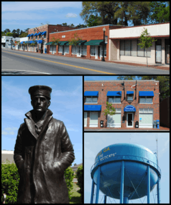
Top, left to right: Downtown Kingsland, statue representing the United States Navy in the Kingsland Veterans Park, Kingsland City Hall, water tower. | |
| Motto: "The city of royal treatment" | |
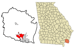 Location in Camden County and the state of Georgia | |
| Coordinates: 30°47′41″N 81°40′18″W / 30.79472°N 81.67167°WCoordinates: 30°47′41″N 81°40′18″W / 30.79472°N 81.67167°W | |
| Country | United States |
| State | Georgia |
| County | Camden |
| Area | |
| • Total | 45.0 sq mi (116.5 km2) |
| • Land | 42.7 sq mi (110.7 km2) |
| • Water | 2.2 sq mi (5.8 km2) |
| Elevation | 36 ft (11 m) |
| Population (2010) | |
| • Total | 15,946 |
| • Density | 373/sq mi (144.1/km2) |
| Time zone | Eastern (EST) (UTC-5) |
| • Summer (DST) | EDT (UTC-4) |
| ZIP code | 31548 |
| Area code(s) | 912 |
| FIPS code | 13-43640[1] |
| GNIS feature ID | 0316462[2] |
| Website |
www |
Kingsland is a city in Camden County, Georgia, United States. The population was 15,946 at the 2010 census.[3]
The Kingsland Commercial Historic District was added to the National Register of Historic Places March 17, 1994. It includes the area surrounding South Lee Street between King Street and William Street.
Kingsland hosts an annual Catfish Festival on Labor Day weekend each year.
History
In 1788, the King family bought large amounts of land west of St. Marys. The Kings named the plantation Woodlawn. The great-grandson of John King, William King, later built a home on "King's Land." On Christmas Day in 1893 the first passenger train (the Florida Central and Peninsular Railroad, today's CSX Railroad) rolled into Camden County right across King’s property. As Mr. William King's house was the only one in site, the railroad company named the area “Kings Land.” With the coming of the railroad, people from all areas began to build in and around Kings Land setting a new era in motion. After the railroad was developed, William Henry King mapped out the town to be located on his property and named it in his honor. Stores and businesses were open and he became the first mayor when the City of Kingsland was incorporated in 1908. Presumably, this was when the town’s two-word title became only one word. The first Kingsland newspaper was published on April 5, 1895 by the Southeast Georgian.[4]
In 1928, the nation's first Maine to Miami road, known in Georgia as the Dixie Highway, was being planned, although it wouldn’t open and pass through Kingsland until 1927. Until that time most people used the St Marys River ferry to cross back and forth between St Marys and Kingsland. Before the wide spread use of automobiles, water traffic was an essential means of transportation for the residents and businesses of Camden County. [5]
The City’s Police and Volunteer Fire Departments have been traced back to 1942 and 1943, respectively. The first fire truck in the 1940s consisted of an army wagon with a pump on it that would be pulled by the first pickup truck to get there. In the 1950s the first fire truck was built by putting the old tank and pump on a 1953 Chevrolet chassis. The first factory built truck was purchased in 1968. In 1973, the first ambulance license was issued to Kingsland Fire Rescue and they served the whole county.
In 1969 the City bought its first garbage truck, a Ford Packard and began charging for pickup. Before that time, a flat bed truck was used and there was not a fee charged. The City operated its own landfill until 1992.
In April 2007, the largest wild fire in Georgia history, the Bugaboo Scrub Fire started in the nearby Okefenokee Swamp. Kingsland was blanketed in smoke until the fire came under control.
Geography
Kingsland is located in southwestern Camden County at 30°47′41″N 81°40′18″W / 30.79472°N 81.67167°W (30.794612, -81.671720),[6] just north of the Florida line. It is bordered by St. Marys to the east. Interstate 95 runs through the eastern part of the city, with access from four exits. U.S. Route 17, an older highway running parallel to I-95, passes through the center of Kingsland. Jacksonville, Florida, is 36 miles (58 km) to the south, and Brunswick is 34 miles (55 km) to the north.
According to the United States Census Bureau, recent annexations by the city of large tracts of land have resulted in a total area of 45.0 square miles (116.5 km2), of which 42.7 square miles (110.7 km2) is land and 2.2 square miles (5.8 km2), or 4.99%, is water.[3] This recent growth makes Kingsland the twelfth largest city in the state of Georgia by land mass.[7]
Climate
| Climate data for Kingsland, Georgia | |||||||||||||
|---|---|---|---|---|---|---|---|---|---|---|---|---|---|
| Month | Jan | Feb | Mar | Apr | May | Jun | Jul | Aug | Sep | Oct | Nov | Dec | Year |
| Average rainfall inches (mm) | 2.86 (72.6) |
2.44 (62) |
1.65 (41.9) |
5.67 (144) |
1.07 (27.2) |
4.47 (113.5) |
6.26 (159) |
9.13 (231.9) |
6.19 (157.2) |
1.11 (28.2) |
3.94 (100.1) |
1.93 (49) |
3.89 (98.8) |
| Average relative humidity (%) (daily average) | 82.3 | 77.2 | 84.2 | 83.6 | 78.1 | 80.4 | 83.7 | 84.9 | 89.2 | 86.6 | 89.4 | 88.2 | 83.9 |
| Source: [8] | |||||||||||||
Demographics
| Historical population | |||
|---|---|---|---|
| Census | Pop. | %± | |
| 1910 | 190 | — | |
| 1920 | 296 | 55.8% | |
| 1930 | 444 | 50.0% | |
| 1940 | 619 | 39.4% | |
| 1950 | 1,169 | 88.9% | |
| 1960 | 1,536 | 31.4% | |
| 1970 | 1,831 | 19.2% | |
| 1980 | 2,008 | 9.7% | |
| 1990 | 4,699 | 134.0% | |
| 2000 | 10,506 | 123.6% | |
| 2010 | 15,946 | 51.8% | |
| Est. 2015 | 16,487 | [9] | 3.4% |
As of the census[1] of 2000, there were 10,506 people, 3,620 households, and 2,722 families residing in the city. The population density was 627.9 people per square mile (242.5/km²). There were 4,203 housing units at an average density of 251.2 per square mile (97.0/km²). The racial makeup of the city was 73.25% White, 21.14% African American, 0.58% Native American, 1.54% Asian, 0.06% Pacific Islander, 1.24% from other races, and 2.19% from two or more races. Hispanic or Latino of any race were 3.61% of the population.
There were 3,620 households out of which 50.1% had children under the age of 18 living with them, 60.4% were married couples living together, 11.0% had a female householder with no husband present, and 24.8% were non-families. 19.0% of all households were made up of individuals and 3.3% had someone living alone who was 65 years of age or older. The average household size was 2.90 and the average family size was 3.34.
In the city the population was spread out with 34.8% under the age of 18, 10.1% from 18 to 24, 38.5% from 25 to 44, 13.0% from 45 to 64, and 3.6% who were 65 years of age or older. The median age was 28 years. For every 100 females there were 100.7 males. For every 100 females age 18 and over, there were 98.4 males.
The median income for a household in the city was $41,303, and the median income for a family was $44,708. Males had a median income of $32,795 versus $20,856 for females. The per capita income for the city was $14,997. About 8.1% of families and 9.6% of the population were below the poverty line, including 9.0% of those under age 18 and 28.8% of those age 65 or over.
Education
Higher education
Secondary
Primary
- Camden County Middle School
- St. Marys Middle School
- Kingsland Elementary School
- Matilda Harris Elementary School
- David L. Rainer Elementary School
- Mamie Lou Gross Elementary School
- Crooked River Elementary School
- Woodbine Elementary School
- St. Marys Elementary School
- Sugarmill Elementary School
- Mary Lee Clark Elementary School
Private schools
- Coastal Academy
- New Hope Christian Academy
References
- 1 2 "American FactFinder". United States Census Bureau. Retrieved 2008-01-31.
- ↑ "US Board on Geographic Names". United States Geological Survey. 2007-10-25. Retrieved 2008-01-31.
- 1 2 "Geographic Identifiers: 2010 Demographic Profile Data (G001): Kingsland city, Georgia". U.S. Census Bureau, American Factfinder. Retrieved July 17, 2014.
- ↑ Kingsland Georgia -- 100 year History http://www.kingslandgeorgia.com/106/History. Retrieved 15 July 2016. Missing or empty
|title=(help) - ↑ History (100 Year) [That same year, the nation's first Maine to Miami road, known in Georgia as the Dixie Highway, was being planned, although it wouldn’t open and pass through Kingsland until 1927. Until that time most people used the St Marys River ferry to cross back and forth between St Marys and Kingsland. Before the wide spread use of automobiles, water traffic was an essential means of transportation for the residents and businesses of Kingsland. Besides the ferry, there were other large vessels available for passengers to use from Kingsland that was approx four miles south of town. That same year, the nation's first Maine to Miami road, known in Georgia as the Dixie Highway, was being planned, although it wouldn’t open and pass through Kingsland until 1927. Until that time most people used the St Marys River ferry to cross back and forth between St Marys and Kingsland. Before the wide spread use of automobiles, water traffic was an essential means of transportation for the residents and businesses of Kingsland. Besides the ferry, there were other large vessels available for passengers to use from Kingsland that was approx four miles south of town.] Check
|url=value (help). Retrieved 15 July 2016. Missing or empty|title=(help) - ↑ "US Gazetteer files: 2010, 2000, and 1990". United States Census Bureau. 2011-02-12. Retrieved 2011-04-23.
- ↑ "Geographic Identifiers: 2010 Demographic Profile Data (G001): All Places within Georgia". U.S. Census Bureau, American Factfinder. Retrieved July 17, 2014.
- ↑ "TractorMan, Peeples Rd Kingsland GA". WeatherUnderground. Retrieved July 13, 2016.
- ↑ "Annual Estimates of the Resident Population for Incorporated Places: April 1, 2010 to July 1, 2015". Retrieved July 2, 2016.
- ↑ "Census of Population and Housing". Census.gov. Retrieved June 4, 2015.
External links
Municipalities and communities of Camden County, Georgia, United States | ||
|---|---|---|
| Cities | 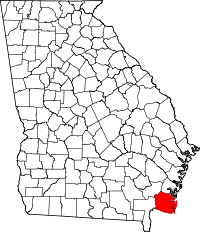 | |
| CDP | ||
| Unincorporated communities | ||