Kingsway Camp
Kingsway Camp officially known as Guru Teg Bahadur Nagar (GTB Nagar), since 1970, is a historic area located in North Delhi, near Civil Lines and Delhi University. It starts from Guru Teg Bahadur Nagar (GTB) Chauraha (passing), and has residential areas like Hudson Lines and Outram Lines. Neighboring localities include Dhaka Village, Mukherjee Nagar and Hakikat Nagar. The foundation of the new capital of British India, New Delhi, was laid at Coronation Park by King George V in December, 1911, making this area historically significant.[1]

Originally named after Kingsway, an avenue which was built as a precursor to the construction of residence of the Viceroy of India, after the Delhi Durbar of 1911, though its location was finally shifted to the Raisina Hill, its present location, as was the road titled Kingsway, now known as Rajpath.[2] The area stretched over twenty-five square miles from banks of Yamuna River in the east to Shalimar Bagh in the west.[3] Post independence in 1947, it became the venue of the largest refugee camp in Delhi, housing 3,00,000 refugees.[4] Today, it is posh residential locality, with a large number of students residing in the area owing to its proximity to the Delhi University; it serviced by the GTB Nagar underground station of Delhi Metro.
History
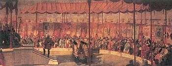
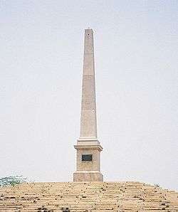
During the British Raj it acquired historic importance due to the presence of the "Coronation Park" close by, now close to the Nirankari Colony, where all the three Delhi Durbar took place, and is now host the Coronation Memorial. Though the most important event took place on December 12, 1911, when George V, the then Emperor of India along with Queen Mary, during the Delhi Durbar, made the announcement that the capital of the Raj was to be shifted from Calcutta to Delhi, subsequently on December 15, 1911, they laid the foundation stone for Viceroy's residence, and New Delhi here, which was subsequently shifted to its present location on Raisina Hill near Rashtrapati Bhavan (President's House).[1][5] The newly appointed emperors of the British Raj were stationed at Kingsway Camp. Since the Kings had to pass through this route, it was named "Kingsway Camp", meaning the "Way Of the King".
In 1910s, a steam generation power plant was established here by the government, which was later shifted to Raj Ghat area around 1931, when the capital of India was shifted to New Delhi, and known as Central Power House.
The Harijan Sevak Sangh for Dalits (untouchables) was established here, by Mahatma Gandhi on September 24, 1932. Later, it was Valmiki Bhawan within the campus, which functioned as Gandhi ji's one-room ashram,. Today, the 20-acre (81,000 m2) campus includes the Gandhi Ashram, Harijan Basti, Lala Hans Raj Gupta Industrial Training Institute and also has a residential school for boys and girls.[6][7]
However, until the independence of India, much of area was still filled with fruit gardens, or remained a wilderness and swamp, due to its low-lying location, which tended to flood during the rainy season[8] though a big change was yet to come. As with India's independence in 1947, Kingway Camp became the venue to the one of many refugee camps set up in Delhi. Here some 3,00,000 people displaced from what was now Pakistan, due to partition of India stayed, making it the largest such camp.[4] Here tents and temporary barracks became home for the people in the coming months.[9][10] Though almost two years after it was built, in May 1949 over 42,000 refugees were still living at the camp as the construction of rehabilitation colonies and houses in area was still underway, that is when the inhabitants of the camp went on a hunger strike.[11] Gandhian Lakshmi Chand Jain was in-charge of working of the camp, which was close to the Gandhi ashram, where Gandhiji held his prayer meetings. Kamaladevi Chattopadhyay also worked extensively at the camp, with women groups and also worked towards forming cooperatives here. Over the next few years a lot of refugees settled in the nearby area itself, many moved to West Delhi residential areas, and some newly buily refugee townships. Though unlike other refugee townships like Nilokheri, Faridabad and Rajpura, there was no attempt to bring residential and economic activity in proximity to one another, nevertheless owing to its proximity with Delhi University the area flourished in the coming years.[12]
The Oznam Home, a noted old-age home was established here, by St. Vincent de Paul Society in 1958, and was run by an Austrian nun, Sister Edith who stayed for the next 30 years.[13] Kingsway Camp was official renamed as Guru Teg Bahadur Nagar on December 12, 1970 by Municipal Corporation of Delhi.[14] All India Radio's first external service shortwave facility was also established here.[15]
Transport
The place is well connected with all the major places in and around Delhi 24x7 transport. The Delhi Metro has also started functioning in this part of North Delhi. Ring road passes through the place.The place also has a inter city bus stand namely BBM Depot, through which direct and convenient public transport is available throughout Delhi.
Overview
It proves to be a great place for students as the place is in the vicinity of Delhi University. Students can find great rent deals. Police vigilance is high as the police training centre and DAP 4th Battalion and Police residential colony are adjacent to this place. Residential colonies like Hudson lane and outram lanes were established by DDA. If looking for a teaching training courses, look for Rapid Career Academy .
Schools
There are a few Public and Private schools in the area like Rosary senior secondary school, DAV, Srijan school, Manav sthali, Darshan, Rapid Career Academy, Little Fairy Public School, Delhi Police Public School etc.
Shopping
Landscape is lush green and two major grounds are POLO and Parade grounds. Rajan Babu Tuberculosis Hospital,[16] Hans Charitable and New Life nursing home are among the few hospitals in the area. One CGHS dispensary is also there. The place offers a wide variety of food that is available in different restaurants such as Samrat, Ramble, Dinners, Cafe Coffee day, and pizzahut. Almost every CAT, IIT JEE and IAS coaching centre is present. Recently many CA/CS/CWA coaching classes have also been set up.The place is also adjacent to Kamla nagar, which is the shopping hub of north Delhi.
References
- 1 2 Hall, P (2002). Cities of Tomorrow. Blackwell Publishing. pp. 198–206. ISBN 0-631-23252-4.
- ↑ Gundry Alexander, Horace (1951). New citizens of India. Oxford University Press (India). p. 43.
- ↑ Singh, p. 318
- 1 2 Ishii, Hiroshi; David N. Gellner; Katsuo Nawa (2007). Political and social transformations in north India and Nepal. Manohar. p. 293. ISBN 81-7304-729-4.
- ↑ Coronation park Hindustan Times, August 14, 2008.
- ↑ "Share Gandhi's space @Rs 800 pm". CNN-IBN. Sep 30, 2006.
- ↑ "Tirath spends time with Dalits on Gandhi Jayanti". The Indian. October 2, 2009.
- ↑ Sinha, p. 1483
- ↑ Pandey, p. 140
- ↑ Tyagi, Vijendra Kumar (1982). Urban growth and urban villages: a case study of Delhi. Kalyani Publishers. p. 24.
- ↑ "Delhi Strike". Pittsburgh Post-Gazette. May 15, 1949. p. 20. Retrieved 22 July 2010.
- ↑ Rao, p. 43
- ↑ Johri, Pradeep Kumar (2005). Social Development And Social Welfare. Anmol Publications. p. 19. ISBN 81-261-2220-X.
- ↑ The Sikh review, Volume 37, Issues 421-432. Sikh Cultural Centre, Calcutta. 1989. p. 53 "Resolution no. 954"
- ↑ Magne, Lawrence (2001). Passport to World Band Radio 2002. International Broadcasting Services. p. 29. ISBN 0-914941-82-8.
- ↑ "MCD prescribes Rs 2,000-cr medicity for North Delhi". Indian Express. Mar 10, 2010.
- Vijendra Kasturi Ranga Varadaraja Rao, Vijendra (1955). An economic review of refugee rehabilitation in India: a study of the Kingsway camp. Dehli School of Economics.
- Singh, Khushwant (1990). Delhi. Penguin Books.
- Pandey, Gyanendra (2001). Remembering partition: violence, nationalism, and history in India. Cambridge University Press. ISBN 0-521-00250-8.
- Sinha, P.C. (2005). Encyclopaedia of Travel, Tourism and Ecotourism, Volume 1. Anmol Publications. ISBN 81-261-2398-2.
AMAL MANOHAR
External links
| Wikimedia Commons has media related to Kingsway Camp. |
Coordinates: 28°24′56″N 77°07′18″E / 28.4155°N 77.1216°E