Kita-ku, Kyoto
| Kita 北区 | |
|---|---|
| Ward of Kyoto | |
|
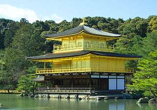
Kinkaku, the Golden Pavilion of Rokuon-ji, is one of the most famous landmarks of Kita-ku. | |
 Location of Kita-ku in Kyoto | |
 Kita Location of Kita-ku in Japan | |
| Coordinates: 35°2′28″N 135°45′15″E / 35.04111°N 135.75417°ECoordinates: 35°2′28″N 135°45′15″E / 35.04111°N 135.75417°E | |
| Founded | 1955 |
| Area | |
| • Total | 94.88 km2 (36.63 sq mi) |
| Highest elevation | 895 m (2,936 ft) |
| Lowest elevation | 60 m (200 ft) |
| Population (October 1, 2015) | |
| • Total | 119,474 |
| • Density | 1,300/km2 (3,300/sq mi) |
| Time zone | Japan Standard Time (UTC+9) |
| Website |
www |
Kita (北区 Kita-ku) is one of the eleven wards in the city of Kyoto, in Kyoto Prefecture, Japan. Its name means "North Ward." As of 2016, the ward has an estimated population of 119,074 people.[1]
Demographics
| Historical population | ||
|---|---|---|
| Year | Pop. | ±% |
| 1960 | 123,230 | — |
| 1970 | 135,681 | +10.1% |
| 1980 | 136,181 | +0.4% |
| 1990 | 127,348 | −6.5% |
| 2000 | 126,125 | −1.0% |
| 2010 | 122,037 | −3.2% |
| 2015 | 119,474 | −2.1% |
| Source: | ||
Education
Universities
- Bukkyo University
- Kyoto Sangyo University
- Ritsumeikan University, Kinugasa Campus
- Otani University
Primary and secondary schools
The community previously had a North Korean school, Kyoto Korean No. 3 Elementary School (京都朝鮮第三初級学校).[2]
Culture
Temples and Landmarks
- Daitoku-ji a famous Rinzai sect temple.
- Kamigamo Shrine, one of the oldest shrines in Japan.
- Kinkaku-ji, the Golden Pavilion, one of Japan's most famous temples.
References
External links
| Wikivoyage has a travel guide for North Kyoto. |
![]() Media related to Kita-ku, Kyoto at Wikimedia Commons
Media related to Kita-ku, Kyoto at Wikimedia Commons
- Official website (Japanese)
| Wards of Kyoto | ||
|---|---|---|
| Cities | ||
| Funai District | ||
| Kuse District | ||
| Otokuni District | ||
| Sōraku District | ||
| Tsuzuki District | ||
| Yosa District | ||
This article is issued from Wikipedia - version of the 11/30/2016. The text is available under the Creative Commons Attribution/Share Alike but additional terms may apply for the media files.