Konopnytsia
| Konopnytsia Коно́пниця | |
|---|---|
| village | |
 Konopnytsia | |
| Coordinates: UA 49°49′00″N 23°51′27″E / 49.81667°N 23.85750°ECoordinates: UA 49°49′00″N 23°51′27″E / 49.81667°N 23.85750°E | |
| Country |
|
| Province |
|
| District |
|
| Established | 1370 |
| Area | |
| • Total | 1,67 km2 (64 sq mi) |
| Elevation/(average value of) | 319 m (1,047 ft) |
| Population | |
| • Total | 562 |
| • Density | 336,53/km2 (87,160/sq mi) |
| Time zone | EET (UTC+2) |
| • Summer (DST) | EEST (UTC+3) |
| Postal code | 81111 |
| Area code | +380 3230 |
| Website | село Конопниця (Ukrainian) |
Konopnytsia (old Name – Sopilka (Fuyarivka), Ukrainian: Коно́пниця, Сопілка (Фуярівка)) – is a village (selo)[1] in Pustomyty Raion, Lviv Oblast of Western Ukraine.
Local government is administered by Konopnytska village council.[2]
Geography
Area of the village totals is 1,67 km2 and is located along the Highway in Ukraine ![]() connecting Lviv with Przemyśl. Distance from the regional center Lviv is 14 kilometres (8.7 mi) , 18 kilometres (11 mi) from the district center Pustomyty, and 84 kilometres (52 mi) from Przemyśl.
connecting Lviv with Przemyśl. Distance from the regional center Lviv is 14 kilometres (8.7 mi) , 18 kilometres (11 mi) from the district center Pustomyty, and 84 kilometres (52 mi) from Przemyśl.
History
The first written mention of the village Sopilka dates back to 1370 year. But in Polish documents 16th - 19th centuries been writing name Fuyarivka.[3]
But the village Konopnytsia was really built up in the early twentieth century, when it was populated by immigrants from Western Poland. The Polish writer Maria Konopnicka was visited the village Konopnytsia. There is a record of the opening of the school in the village Konopnytsia (1914).
The village was inhabited again after the 1944-1946 forced resettlement of Ukrainians from Poland to the Soviet Union (Ukrainian SSR and Siberia).
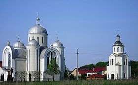
Religious buildings
- Church of the Nativity the Blessed Virgin Mary (stone, 1993).