Kostelec nad Orlicí
| Kostelec nad Orlicí | |||
| Town | |||
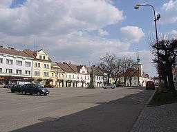 Palacký Square | |||
|
|||
| Official name: Kostelec nad Orlici | |||
| Country | Czech Republic | ||
|---|---|---|---|
| State | (Bohemia) | ||
| Region | Hradec Králové | ||
| District | Rychnov nad Kněžnou | ||
| Commune | Kostelec nad Orlicí | ||
| Elevation | 273 m (896 ft) | ||
| Coordinates | CZ 50°07′22″N 16°12′41″E / 50.12278°N 16.21139°ECoordinates: CZ 50°07′22″N 16°12′41″E / 50.12278°N 16.21139°E | ||
| Area | 26.18 km2 (10.11 sq mi) | ||
| Population | 6,220 (2007-12-31) | ||
| Density | 238/km2 (616/sq mi) | ||
| First mentioned | 1303 | ||
| Mayor | Jiří Bartoš | ||
| Timezone | CET (UTC+1) | ||
| - summer (DST) | CEST (UTC+2) | ||
| Postal code | 517 41 | ||
  Location in the Czech Republic | |||
| Wikimedia Commons: Kostelec nad Orlicí | |||
| Statistics: statnisprava.cz | |||
| Website: www | |||

Kostelec nad Orlicí (Czech pronunciation: [ˈkostɛlɛts ˈnat ʔorlɪtsiː]; German: Adlerkosteletz) is a town in the Hradec Králové Region of the Czech Republic located about 7 km southwest of Rychnov nad Kněžnou and 29 km east-southeast of Hradec Králové. It has 6,220 inhabitants (2007).
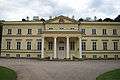 New Chateau
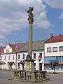 Marian plaque column
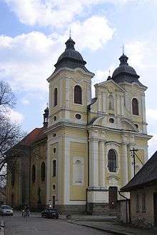 St George church
External links
-
 Media related to Kostelec nad Orlicí at Wikimedia Commons
 - Municipal website (Czech)
This article is issued from Wikipedia - version of the 4/4/2016. The text is available under the Creative Commons Attribution/Share Alike but additional terms may apply for the media files.