Lípa nad Orlicí
| Lípa nad Orlicí | |||
|---|---|---|---|
| Municipality and village | |||
 | |||
| |||
| Coordinates: 50°8′10″N 16°6′4″E / 50.13611°N 16.10111°ECoordinates: 50°8′10″N 16°6′4″E / 50.13611°N 16.10111°E | |||
| Country |
| ||
| Region | Hradec Králové Region | ||
| District | Rychnov nad Kněžnou District | ||
| Government | |||
| • Mayor | Monika Vrátilová | ||
| Area | |||
| • Total | 4.08 sq mi (10.57 km2) | ||
| Elevation | 827 ft (252 m) | ||
| Population (2014) | |||
| • Total | 519 | ||
| Time zone | CET (UTC+1) | ||
| • Summer (DST) | CEST (UTC+2) | ||
| Website | http://www.lipanadorlici.cz/ | ||


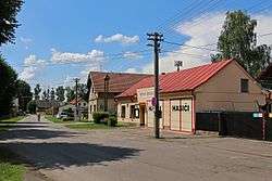
Lípa nad Orlicí is a village and municipality in Rychnov nad Kněžnou District in the Hradec Králové Region of the Czech Republic. It is located 20 kilometres (12 mi) southeast of Hradec Králové and 120 kilometres (75 mi) east of Prague.
The municipality covers an area of 10.57 square kilometres (4.08 sq mi) and as of 2014 it had a population of 519. First written notice about the village is from year 1396.
The village of Dlouhá Louka is an administrative part of Lípa nad Orlicí.
| Wikimedia Commons has media related to Lípa nad Orlicí. |
This article is issued from Wikipedia - version of the 10/23/2016. The text is available under the Creative Commons Attribution/Share Alike but additional terms may apply for the media files.