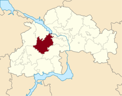
Krynychky Raion
| Krynychky Raion Криничанський район | |||
|---|---|---|---|
| Raion | |||
| |||
 | |||
| Coordinates: 48°21′46″N 34°27′40″E / 48.36278°N 34.46111°ECoordinates: 48°21′46″N 34°27′40″E / 48.36278°N 34.46111°E | |||
| Country |
| ||
| Region | Dnipropetrovsk Oblast | ||
| Admin. center | Krynychky | ||
| Subdivisions |
List
| ||
| Area | |||
| • Total | 1,684 km2 (650 sq mi) | ||
| Population | |||
| • Total | 36,041 | ||
| • Density | 21/km2 (55/sq mi) | ||
| Time zone | EET (UTC+2) | ||
| • Summer (DST) | EEST (UTC+3) | ||
| Area code | +380 | ||

Krynychky Raion (Ukrainian: Криничанський район) is a raion (district) of Dnipropetrovsk Oblast, southeastern-central Ukraine. Its administrative centre is located at the urban-type settlement of Krynychky. Population: 36,041 (2013 est.)[1].
References
- ↑ "Чисельність наявного населення України (Actual population of Ukraine)" (in Ukrainian). State Statistics Service of Ukraine. Retrieved 21 January 2015.
| Raions | |||||||
|---|---|---|---|---|---|---|---|
| Cities |
| ||||||
| |||||||
This article is issued from Wikipedia - version of the 2/1/2016. The text is available under the Creative Commons Attribution/Share Alike but additional terms may apply for the media files.