Kujalleq
| Kujalleq Municipality Kommune Kujalleq | ||
|---|---|---|
| Municipality | ||
|
| ||
| ||
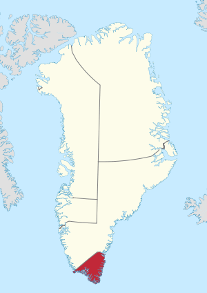 Location of Kujalleq within Greenland | ||
| Coordinates (Kujalleq Commune): 61°00′N 45°00′W / 61.000°N 45.000°WCoordinates: 61°00′N 45°00′W / 61.000°N 45.000°W | ||
| State |
| |
| Constituent country |
| |
| Municipality |
| |
| Established | 1 January 2009 | |
| Municipal center | Qaqortoq | |
| Government[1] | ||
| • Mayor | Jørgen Wæver Johansen (Siumut) | |
| Area[2] | ||
| • Total | 32,000 km2 (12,355 sq mi) | |
| Population (2013)[3] | ||
| • Total | 7,151 | |
| • Density | 0.223/km2 (0.58/sq mi) | |
| Time zone | UTC-03 | |
| Calling code | +299 | |
| ISO 3166 code | GL-KU | |
| Website | kujalleq.gl | |
Kujalleq (Greenlandic: Kommune Kujalleq, "South") is a new municipality in the southern tip of Greenland, operational from 1 January 2009. With 7,151 inhabitants as of January 2013,[3] it is the least-populated municipality in Greenland. The administrative center of the municipality is in Qaqortoq (formerly called Julianehåb). The municipality consists of the former municipalities of southern Greenland, each named after the biggest settlement:[1]
- Nanortalik Municipality
- Narsaq Municipality
- Qaqortoq Municipality
In addition to the area of the former municipalities, the southernmost tip of Greenland was added to the new administrative entity. The land area stretches from the Kangerlussuatsiaq fjord (in Danish Lindenowfjorden) to the southeastern Atlantic coast and Cape Farewell. The area previously belonged to Ammassalik Municipality and is uninhabited.
Coat of Arms
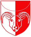
The coat of arms of the municipality depicts a ram's head,[4] symbolising the sheep farming in the area, which has become one of the most important parts of Kujalleq's economy. The uppermost part of the shield contains the sun of the Greenlandic flag. Likewise the choice of colours matches those of the country's flag. The coat of arms was adopted in August 2008.
Geography
At 32,000 km2 (12,355.3 sq mi) Kujalleq is the smallest municipality in Greenland by area. Straddling the southernmost end of the island of Greenland, it is bordered by only one municipality, Sermersooq, in the north. The waters of the western coast are that of Labrador Sea, which meet the open North Atlantic at Uummannarsuaq, the southern cape. The border on the western coast runs alongside Alanngorsuaq Fjord and on the eastern coast up to Anorituup Kangerlua (Anoritoq) Fjord.
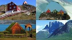
The entire municipal area is highly mountainous, with numerous fjords carving deeply into the land. All settlements are located on the Western coast, or in fjords ending there.
Towns and settlements
- Nanortalik area
- Nanortalik (Nennortalik)
- Aappilattoq
- Alluitsup Paa (Sydprøven)
- Ammassivik (Sletten)
- Narsarmijit (Frederiksdal, Narsaq Kujalleq)
- Tasiusaq
- Qorlortorsuaq
- Narsaq area
- Narsaq (Nordprøven)
- Igaliku (Igaliko)
- Narsarsuaq
- Qassiarsuk
- Qaqortoq area
- Qaqortoq (Julianehåb)
- Eqalugaarsuit
- Qassimiut
- Saarloq
Transportation
The only airport is Narsarsuaq Airport. Helicopters and boats go to other settlements.
International relations
Twin towns — Sister cities
Kujalleq is twinned with:
See also
- KANUKOKA, the Greenlandic municipal association
- Eastern Settlement, the former Norse settlement in the area
- Lichtenfels & Lichtenau, former Moravian missions in the area
References
| Wikimedia Commons has media related to Kujalleq. |
- 1 2 "Kommune Kujalleq". Kujalleq Municipality. Retrieved 11 July 2010.
- ↑ Statistics Greenland, Greenland in Figures 2010
- 1 2 Greenland in Figures 2013 (PDF). Statistics Greenland. ISBN 978-87-986787-7-9. ISSN 1602-5709. Retrieved 2 September 2013.
- ↑ "Kujalleq - Civic heraldry of Greenland". HeraldryWeb. Retrieved May 9, 2011.
- ↑ "Venskabsbyer: Aarhus Kommune". Aarhus.dk. Retrieved 2013-03-25.
Administrative divisions of Greenland (since 2009) | ||
|---|---|---|
| Municipalities | ||
| Unincorporated Areas |
| |