L'Enfant Plan
|
Original L'Enfant Plan of Washington from national archives | |
 | |
| Location | Washington, D.C. |
|---|---|
| Coordinates | 38°53′26″N 77°1′13″W / 38.89056°N 77.02028°WCoordinates: 38°53′26″N 77°1′13″W / 38.89056°N 77.02028°W |
| NRHP Reference # | 97000332 |
| Designated | April 24, 1997[1] |
The L'Enfant Plan[2] for the city of Washington is the urban plan developed in 1791 by Major Pierre (Peter) Charles L'Enfant for George Washington, the first President of the United States.[3][4]
History
Major L'Enfant was a French engineer who served in the American Revolutionary War.[5] In 1789, when discussions were underway regarding a new federal capital city for the United States, L'Enfant wrote to President Washington asking to be commissioned to plan the city. However, any decision on the capital was put on hold until July 1790 when Congress passed the Residence Act.[6] The legislation, which was the result of a compromise brokered by Alexander Hamilton and Thomas Jefferson, specified the new capital be situated on the Potomac River, at some location between the Eastern Branch (the Anacostia River) and the Connogochegue, near Hagerstown, Maryland. The Residence Act gave authority to President Washington to appoint three commissioners to oversee the survey of the federal district and "according to such Plans, as the President shall approve," provide public buildings to accommodate the Federal government in 1800.[7][8]
President George Washington appointed L'Enfant in 1791 to design the new capital city (later named the City of Washington) under the supervision of three Commissioners, whom Washington had appointed to oversee the planning and development of the ten-mile square of federal territory that would later become the District of Columbia. Thomas Jefferson, who worked alongside President Washington in overseeing the plans for the capital, sent L'Enfant a letter outlining his task, which was to provide a drawing of suitable sites for the federal city and the public buildings. Though Jefferson had modest ideas for the Capital, L'Enfant saw the task as far more grandiose, believing he was not only locating the capital, but also included devising the city plan and designing the buildings.[9]
L'Enfant arrived in Georgetown on March 9, 1791, and began his work, from Suter's Fountain Inn.[10] Washington arrived on March 28, to meet with L'Enfant and the Commissioners for several days.[11] On June 22, L'Enfant presented his first plan for the federal city to President.[12][13][14] On August 19, he appended a new map to a letter that he sent to the President.[13][15]
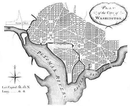
President Washington retained one of L'Enfant's plans, showed it to Congress, and later gave it to the three Commissioners.[16] The U.S. Library of Congress now holds both the plan that Washington apparently gave to the Commissioners and an undated anonymous survey map that the Library considers L'Enfant to have drawn before August 19, 1791.[16][17] The survey map may be one that L'Enfant appended to his August 19 letter to the President.[18]
L'Enfant's "Plan of the city intended for the permanent seat of the government of the United States..." encompassed an area bounded by the Potomac River, the Eastern Branch, the base of the escarpment of the Atlantic Seaboard Fall Line, and Rock Creek.[14][19] His plan specified locations for the "Congress house" (the Capitol), which would be built on Jenkins Hill, and the "President's house" (the White House), which would be situated on a ridge parallel to the Potomac River.[20] L'Enfant envisioned the President's house to have public gardens and monumental architecture. Reflecting his grandiose visions, he specified that the President's house would be five times the size of the building that was actually constructed.[9] Emphasizing the importance of the new nation's legislature, the Congress house would be located on a longitude designated as 0,0° (see: Washington meridians).[15][21][22][23]
L'Enfant's plan contained the following explanatory note:
In order to execute the above plan, Mr. Ellicott drew a true meridian line by celestial observation, which passes through the area intended for the Congress-House; this line he crossed by another line due east and west and which passes through the same area. These lines were accurately measured, and made the basis on which the whole plan was executed. He ran all the lines by a transit instrument, and determined the acute angles by actual measurement, and left nothing to the uncertainty of the compass.[22]
The plan specified that most streets would be laid out in a grid. To form the grid, some streets would travel in an east-west direction, while others would travel in a north-south direction. Diagonal avenues later named after the states of the union crossed the grid.[23][24][25] The diagonal avenues intersected with the north-south and east-west streets at circles and rectangular plazas that would later honor notable Americans and provide open space.
L'Enfant laid out a 400 foot (122m)-wide garden-lined "grand avenue," which he expected to travel for about 1 mile (1.6 km) along an east-west axis in the center of an area that would later become the National Mall.[24] He also laid out a narrower avenue (Pennsylvania Avenue) which would connect the Congress house with the President's house.[15][24] In time, Pennsylvania Avenue developed into the capital city's present "grand avenue."
L'Enfant's plan additionally laid out a system of canals (later designated as the Washington City Canal) that would pass the Congress house and the President's house. One branch of the canal would empty into the Potomac River south of the "President's house" at the mouth of Tiber Creek, which would be channelized and straightened.[24]
L'Enfant secured the lease of quarries at Wigginton Island and along Aquia Creek in Virginia to supply stone for the foundation of the Congress house in November 1791.[26] However, his temperament and his insistence that his city design be realized as a whole, brought him into conflict with the Commissioners, who wanted to direct the limited funds available into construction of the federal buildings. In this, they had the support of Thomas Jefferson.
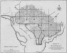
During a contentious period in February 1792, Andrew Ellicott, who had been conducting the original boundary survey of the future District of Columbia (see: Boundary Stones (District of Columbia)) and the survey of the federal city under the direction of the Commissioners, informed the Commissioners that L'Enfant had not been able to have the city plan engraved and had refused to provide him with the original plan (of which L'Enfant had prepared several versions).[27][28][29] Ellicott, with the aid of his brother, Benjamin Ellicott, then revised the plan, despite L'Enfant's protests.[27][28][29][30]
Ellicott stated in his letters that, although he was refused the original plan, he was familiar with L'Enfant's system and had many notes of the surveys that he had made himself. It is therefore possible that Ellicott recreated the plan.[31]
Some of Ellicott's revisions, such as the straightening of the longer avenues, created minor changes to the city's layout, including the removal of Square No. 15 from L'Enfant's original plan. Shortly thereafter, Washington dismissed L'Enfant. After L'Enfant departed, Andrew Ellicott continued the city survey in accordance with the revised plan, several versions of which were engraved, published and distributed. As a result, Ellicott's revisions subsequently became the basis for the capital city's development.[27][28][32][33][34][35]
The work of André Le Nôtre, particularly his Gardens of Versailles, is said to have influenced L'Enfant’s master plan for the capital.[36]
List of contributing parks
- Reservation 1 President's Park
- Reservation 2–6 National Mall; U.S. Capitol Grounds
- Reservation 7 Judiciary Square
- Reservation 8 Mount Vernon Square
- Reservation 9 Franklin Square
- Reservation 10 Lafayette Square
- Reservation 11 McPherson Square
- Reservation 12 Farragut Square
- Reservation 13 Rawlins Square
- Reservation 14 Lincoln Park
- Reservation 15 Stanton Square
- Reservation 16 Folger Park
- Reservation 17 Garfield Park
- Reservation 18 Marion Park
- Reservation 25–27 Washington Circle
- Reservation 32–33 Freedom Plaza
- Reservation 35–36 Market Square
- Reservation 38–43 Seward Square
- Reservation 44–49 Eastern Market Metro
- Reservation 59–61 Dupont Circle
- Reservation 62–64 Scott Circle
- Reservation 65–67 Thomas Circle
- Reservation 68–69 Gompers Park
- Reservation 152–154; 163–164 Logan Circle
- Reservation 332 West Potomac Park
- Reservation 333 East Potomac Park
- Reservation 334 Columbus Plaza
- Reservation 617 Pershing Park
List of contributing avenues
- Connecticut Avenue
- Delaware Avenue
- Indiana Avenue
- Kentucky Avenue
- Louisiana Avenue
- Maryland Avenue
- Massachusetts Avenue
- New Hampshire Avenue
- New Jersey Avenue
- New York Avenue
- North Carolina Avenue
- Pennsylvania Avenue
- Georgia Avenue
- Rhode Island Avenue
- South Carolina Avenue
- Tennessee Avenue
- Vermont Avenue
- Virginia Avenue
List of contributing streets
- 16th Street
- Constitution Avenue
- East Capitol Street
- Independence Avenue
- H Street
- K Street
- North Capitol Street
- South Capitol Street[3]
See also
Notes
- ↑ National Park Service (2009-03-13). "National Register Information System". National Register of Historic Places. National Park Service.
- ↑ "The L'Enfant Plan". A Monument To Democracy: History of the Mall: The 1791 L'Enfant Plan and the Mall. National Coalition to Save Our Mall. Retrieved 2012-01-08.
- 1 2 3 Leach, Sara Amy; Barthold, Elizabeth (1994-07-20). "L'Enfant Plan of the City of Washington, District of Columbia" (PDF). National Register of Historic Places Registration Form. United States Department of the Interior: National Park Service. Retrieved 2012-01-08.
- ↑ L'Enfant identified himself as "Peter Charles L'Enfant" during most of his life, while residing in the United States. (See: Bowling, 2002) He wrote this name on his "Plan of the city intended for the permanent seat of the government of t(he) United States ...." (Washington, D.C.) and on other legal documents. However, during the early 1900s, a French ambassador to the U.S., Jean Jules Jusserand, popularized the use of L'Enfant's birth name, "Pierre Charles L'Enfant". (See: Bowling (2002).) The National Park Service has identified L'Enfant as "Major Peter Charles L'Enfant" and as "Major Pierre (Peter) Charles L'Enfant" in its histories of the Washington Monument on its website. The United States Code states in 40 U.S.C. § 3309: "(a) In General.—The purposes of this chapter shall be carried out in the District of Columbia as nearly as may be practicable in harmony with the plan of Peter Charles L'Enfant."
- ↑ "The L'Enfant and McMillan Plans". Washington, D.C., A National Register of Historic Places Travel Inventory. National Park Service. Retrieved 2011-01-08.
- ↑ Reps, John William (1965), "9. Planning the National Capital", The Making of Urban America, Princeton University Press, pp. 240–242, ISBN 0-691-00618-0
- ↑ "An ACT for establishing the Temporary and Permanent Seat of the Government of the United States". Library of Congress. Retrieved 2008-12-12.
- ↑ Ellis, Joseph J. (2002). "The Dinner". Founding Brothers: The Revolutionary Generation. Vintage. pp. 50–52. ISBN 0-375-70524-4.
- 1 2 Seale, William (1986). The President's House, Volume 1. White House Historical Association. pp. 1–4.
- ↑ Stewart, p. 50
- ↑ Seale, William (1986). The President's House, Volume 1. White House Historical Association. p. 9.
- ↑ L'Enfant, P.C. (June 22, 1791). "L'Enfant's Reports To President Washington Bearing Dates of March 26, June 22, and August 19, 1791: To The President of the United States". Records of the Columbia Historical Society. Washington, D.C.: Columbia Historical Society (1899). 2: 32–37. Retrieved 2011-12-28.
- 1 2 Stewart, p. 52
- 1 2 Passanneau, Joseph R. (2004). Washington Through Two Centuries: A History in Maps and Images. New York: The Monacelli Press, Inc. pp. 14–16, 24–27. ISBN 1-58093-091-3.
- 1 2 3 L'Enfant, P.C. (August 19, 1791). "L'Enfant's Reports To President Washington Bearing Dates of March 26, June 22, and August 19, 1791: To The President of the United States". Records of the Columbia Historical Society. Washington, D.C.: Columbia Historical Society (1899). 2: 38–48. Retrieved 2011-12-28.
- 1 2 "Pierre Charles L'Enfant's 1791 "Plan of the city intended for the permanent seat of the government ...."". Library of Congress. Retrieved 2008-08-13. Note: The plan that this web page describes identifies the plan's author as "Peter Charles L'Enfant". The web page nevertheless identifies the author as "Pierre-Charles L'Enfant."
- ↑ "L'Enfant's Dotted line map of Washington, D.C., 1791, before Aug. 19th.". Library of Congress. Retrieved 2009-09-30.
- ↑ "A Washington DC Map Chronology". dcsymbols.com. Retrieved 2009-09-30.
- ↑ Faethz, E.F.M.; Pratt, F.W. (1874). "Sketch of Washington in embryo, viz: Previous to its survey by Major L'Enfant: Compiled from the rare historical researches of Dr. Joseph M. Toner ... combined with the skill of S.R. Seibert C.E.". Map in the collection of the Library of Congress. Encyclopædia Britannica Online. Archived from the original on 2013-12-27. Retrieved 2012-04-03.
- ↑ Vlach, John Michael (Spring 2004). "The Mysterious Mr. Jenkins of Jenkins Hill". Capitol History: The Capitol Dome. United States Capitol Historical Society. Archived from the original on 2008-07-05. Retrieved 2009-09-14.
- ↑ Federal Writers' Project (1937). Washington, City and Capital: Federal Writers' Project. Works Progress Administration / United States Government Printing Office. p. 210. At Hathi Trust Digital Library
- 1 2 L'Enfant, Peter Charles (1791). "Plan of the city intended for the permanent seat of the government of t(he) United States : projected agreeable to the direction of the President of the United States, in pursuance of an act of Congress passed the sixteenth day of July, MDCCXC, "establishing the permanent seat on the bank of the Potowmac": (Washington, D.C.)". Photocopy of annotated facsimile created by U.S. Coast and Geodetic Survey, Washington, D.C. (1887). Library of Congress. Retrieved 2016-01-26.
- 1 2 Moore, Charles (ed) (1902), "Fig. No. 61 -- L'Enfant Map of Washington (1791), facing p. 12", The Improvement Of The Park System Of The District of Columbia: Report by the United States Congress: Senate Committee on the District of Columbia and District of Columbia Park Commission, Washington, D.C.: Government Printing Office, Fifty-Seventh Congress, First Session, Senate Report No. 166
- 1 2 3 4 (1) "High resolution image of central portion of The L'Enfant Plan for Washington, with transcribed excerpts of key to map". Library of Congress. Retrieved 2009-10-23.
(2) "Enlarged image of central portion of The L'Enfant Plan for Washington" (PDF). National Park Service. Retrieved 2009-10-23. - ↑ Freedom Plaza in downtown D.C. contains an inlay of the central portion of L'Enfant's plan, an inlay of an oval that gives the title of the plan and the name of its author (identified as "Peter Charles L'Enfant") and inlays of the plan's legends. The coordinates of the inlay of the plan and its legends are: 38°53′45″N 77°01′50″W / 38.8958437°N 77.0306772°W. The coordinates of the name "Peter Charles L'Enfant" are: 38°53′45″N 77°01′52″W / 38.8958374°N 77.031215°W
- ↑ Morgan, p. 120
- 1 2 3 Tindall, William (1914). "IV. The First Board of Commissioners". Standard History of the City of Washington From a Study of the Original Sources. Knoxville, Tennessee: H. W. Crew and Company. pp. 148–149.
- 1 2 3 Stewart, pp. 55-56
- 1 2 Ellicott, Andrew (February 23, 1792). "To Thomas Johnson, Daniel Carroll and David Stuart, Esqs." In Arnebeck, Bob. "Ellicott's letter to the commissioners on engraving the plan of the city, in which no reference is made to Banneker". The General and the Plan. Bob Arnebeck's Web Pages. Retrieved 2010-08-30.
- ↑ Kite, from L'Enfant and Washington" in website of Grand Lodge of British Columbia and Yukon, Ancient Free and Accepted Masons (Freemasons). Retrieved January 11, 2009.
- ↑ Partridge, p. 23
- ↑ Bowling, Kenneth R. (1988). Creating the federal city, 1774-1800 : Potomac fever. Washington, D.C.: American Institute of Architects Press.
- ↑ Bryan, W.B. (1899). "Something About L'Enfant And His Personal Affairs". Records of the Columbia Historical Society. 2: 113.
- ↑ The L'Enfant and McMillan Plans in "Washington, D.C., A National Register of Historic Places Travel Inventory" in official website of the U.S. National Park Service Accessed August 14, 2008.
- ↑ Washington Map Society: Plan of the City of Washington. The U.S. National Archives holds a copy of "Ellicott's engraved Plan superimposed on the Plan of L'Enfant showing the changes made in the engraved Plan under the direction of President Washington". See "Scope & Contents" page of "Archival Description" for National Archives holding of "Miscellaneous Oversize Prints, Drawings and Posters of Projects Associated with the Commission of Fine Arts, compiled 1893 – 1950", ARC Identifier 518229/Local Identifier 66-M; Series from Record Group 66: Records of the Commission of Fine Arts, 1893 – 1981. Record of holding obtained through search in Archival Descriptions Search of ARC — Archival Research Catalog using search term L'Enfant Plan Ellicott, 2008-08-22.
- ↑ "André Le Nôtre". Encyclopædia Britannica. Encyclopædia Britannica Inc. 12 Mar 2012. Retrieved March 12, 2012.
References
- Bowling, Kenneth R (2002). Peter Charles L'Enfant: vision, honor, and male friendship in the early American Republic. George Washington University, Washington, D.C. ISBN 978-0-9727611-0-9.
- Morgan, James Dudley, M.D. (1899). "Maj. Pierre Charles L'Enfant, The Unhonored and Unrewarded Engineer". Records of the Columbia Historical Society. Washington, D.C.: Columbia Historical Society. 2: 118–157. Retrieved 2011-08-15.
- Partridge, William T. (1930). L'Enfant's Methods And Features of His Plan For The Federal City. Reports and plans, Washington region: supplementary technical data to accompany annual report: National Capital Planning Commission. Washington, D.C.: Government Printing Office. pp. 21–38. OCLC 15250016. Retrieved 2016-12-04. At HathiTrust Digital Library.
- Stewart, John (1898). "Early Maps and Surveyors of the City of Washington, D.C". Records of the Columbia Historical Society. 2. Retrieved 2011-12-27.
External links
- Levine, Michael. "Planning Our Capital City: L'Enfant designed more than D.C.: He designed a 200-year-old controversy". History DC Area. DCpages.com. Retrieved 2011-01-08. External link in
|publisher=, |work=(help)