La Guancha (Ponce, Puerto Rico)
| Complejo Recreational y Cultural La Guancha La Guancha Recreational and Cultural Complex | |
|---|---|
|
La Guancha Boardwalk, the centerpice of the La Guancha Recreational Complex | |
| Type | Passive park |
| Location | Bario Playa, Ponce, Puerto Rico |
| Area | approx 20 cuerdas |
| Created | 23 June 1998 |
| Operated by | Autonomous Municipality of Ponce |
| Status | Open every day |
| Parking | Several areas with parking for about 900 vehicles |

| Part of a series on |
| Tourism in Puerto Rico |
|---|
| Tourism Regions |
|
| Beaches |
| Caves |
| Cays and islets |
| Convention centers |
| Culture |
| Islands |
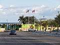
The La Guancha Recreational and Cultural Complex (Spanish: Complejo Recreational y Cultural La Guancha) is a sector located in barrio Playa in Ponce, Puerto Rico with family recreational and cultural facilities that opened on June 23, 1998.[1] The highlight of the complex is La Guancha Boardwalk, which is flanked by a beach, an observation tower, an amphitheater, and 24 open-air kiosks.[2] It was developed during the administration of Mayor Rafael Cordero Santiago.[3]
History
Originally La Guancha consisted of a road alongside a dike built close to the easternmost shore of barrio Playa across from Ponce Yacht Club. The romantic area was frequented by families and sweethearts alike, especially on weekends, for relaxion and bonding. During the administration of Mayor Cordero, however, a number of facilities were added to the La Guancha area at a cost of over $18 million, developing it into a new recreational complex.[4]
Facilities
Seven new facilities were added to the existing boardwalk area:[5]
- The Dr. Enrique "Coco" Vicens Recreational and Cultural Center (Spanish: Centro Recreativo y Cultural Enrique "Coco" Vicéns), which consists of an open-air amphitheater for concert-type facilities and seating some 30,000 spectators.[6] Its stage is known as "Tarima Hector Lavoe".[7]
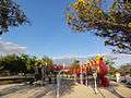
- A rides and amusement park area, intended for the celebration of Patron Saint's Day Festivals, fairs, and similar festivities
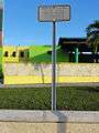
- The Jose Angel Zayas Colon Children's Park, with over 40 games for the youngters, plus the (Julio and Geraldo) Chamorro-Franceschini Brothers Park, with facilities for the handicapped
- Several parking areas with parking for some 900 vehicles, and distributed throughgout the complex
- A majestic fountain, as its main axis, displaying the city's Coat-of-arms and its iconic lion
- A multi-use building providing facilities for the Ponce Municipal Police, medical emergencies and ambulance, and other related agencies
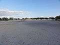
- A nourished beach area with over 10,000 cubic meters of new sand that replenished and built up the previous beach area, and including five beach volleyball courts, gazebos, access ramps to the Caribbean Sea, and associated illumination.
This project complemented the recently inaugurated tourist pier in the nearby Port of Ponce, and which saw an investment of $4 million.[8]
Funding
The Complex was developed by the Department of Community and Economic Development of the Autonomous Municipality of Ponce at a cost of $18.6 million. The breakdown of the cost included $3.6 million in the acquisition of the Paseo Tablado La Guancha, 6.5 million in the purchase of over 27 acres (110,000 m2) of land, $8.0 million in the construction of the project, $0.2 million for the bidding process, and $0.3 million for the upgrade of PR-12 (Avenida Santiago de los Caballeros) as infrastructure leading to the new complex.[9]
Gallery
-

Hector Lavoe Rides and Amusement Plaza (Western End)
-
Rides and Amusement Park Area (Eastern End)
-

Jose Angel Zayas Colon Children's Park sign
-
Children's Playground at the Jose Angel Zayas Colon Children's Park
-

Sign marking the Children's Area
-

Chamorro-Franceschini Bros. Handicapped Children's Park
-
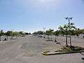
Public parking for over 900 cars at La Guancha
-

Majestic Fountain and Lion at the Entrance to La Guancha
-
Sign marking the Multiuse Building
-
Administrative Multiuse Building
-
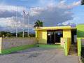
EMS Office at the Multi Use Building
-
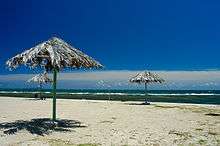
Sand-nourished La Guancha Beach
-

Beach volleyball courts
-

Ponce Municipal Band Gazebo
-

Walkway
See also
External links
References
- ↑ Inaguran Complejo de Recreacion La Guancha. El Nuevo Dia. June 15, 1998. (In Spanish.)
- ↑ Mejoras para La Guancha de Ponce. El Sur a la Vista. 3 February 2011. Retrieved 29 March 2011.
- ↑ Recuerdan en Ponce al León Mayor. Periodico La Perla del Sur.
- ↑ Inaguran Complejo de Recreacion La Guancha. El Nuevo Dia. 15 June 1998. (In Spanish.)
- ↑ Inaguran Complejo de Recreacion La Guancha. El Nuevo Dia. June 15, 1998. (In Spanish.)
- ↑ Meca sureña del sabor y esparcimiento. Arlyn Díaz. La Perla del Sur. Ponce, Puerto Rico. Retrieved 17 August 2010.
- ↑ Para junio restauración del Paseo Tablado. Jason Rodríguez Grafal. La Perla del Sur. Ponce, Puerto Rico. Retrieved 7 March 2012.
- ↑ Remozan al Sector La Guancha en Ponce. El Nuevo Dia. 30 January 1997. (In Spanish.)
- ↑ Inauguran Complejo de Recreacion La Guancha. El Nuevo Dia. 15 June 1998. (In Spanish.)
Coordinates: 17°58′00″N 66°37′03″W / 17.96667°N 66.61750°W