Lake Eyre, South Australia
| Lake Eyre South Australia | |||||||||||||
|---|---|---|---|---|---|---|---|---|---|---|---|---|---|
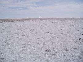 Salt Crust on Lake Eyre gives way to slippery mud | |||||||||||||
 Lake Eyre | |||||||||||||
| Coordinates | 28°32′13″S 137°29′49″E / 28.537°S 137.497°ECoordinates: 28°32′13″S 137°29′49″E / 28.537°S 137.497°E | ||||||||||||
| Population | no data available (2016)[1] | ||||||||||||
| Established | 2013[2] | ||||||||||||
| Postcode(s) | 5733[2] | ||||||||||||
| Time zone | ACST (UTC+9:30) | ||||||||||||
| • Summer (DST) | ACST (UTC+10:30) | ||||||||||||
| Location | |||||||||||||
| LGA(s) | unincorporated area [2][3] | ||||||||||||
| Region | Far North[4] | ||||||||||||
| State electorate(s) | Stuart[5] | ||||||||||||
| Federal Division(s) | Grey[6] | ||||||||||||
| |||||||||||||
| |||||||||||||
| Footnotes |
Location[2] Coordinates[2] Climate[7] Adjoining localities[2] | ||||||||||||
Lake Eyre is a locality in the Australian state of South Australia located about 718 kilometres (446 mi) north of the state capital of Adelaide and 134 kilometres (83 mi) north of the town of Marree and which is associated with the occasional body of water known as Lake Eyre.[2]
The locality was established on 26 April 2013 in respect to “the long established local name.” Its name is derived from the former Lake Eyre National Park.[2][8]
The locality covers the full extent of Lake Eyre including islands within the lake’s extent, the Hunt Peninsula at the southern coast of the northern part of the lake and land on the lake’s east side.[2]
The principal land use within the locality is conservation with its full extent being occupied by the following protected areas - the Elliot Price Conservation Park and the Kati Thanda-Lake Eyre National Park.[2][3]
Lake Eyre is located within the federal Division of Grey, the state electoral district of Stuart, the unincorporated area of South Australia and the state’s Far North region.[3][4][5][6]
See also
References
- ↑ No population data available until the 2016 census
- 1 2 3 4 5 6 7 8 9 10 "Search result for "Lake Eyre (LOCB)" (Record no SA0067087) with the following layers selected - "Suburbs and Localities" and " Place names (gazetteer)"". Property Location Browser. Government of South Australia. Retrieved 20 May 2016.
- 1 2 3 "Development Plan, Land Not Within a Council Area Eyre, Far North, Riverland and Whyalla – 18 October 2012" (PDF). Government of South Australia. 2012. pp. 326 & 231. Retrieved 16 September 2015.
- 1 2 "Far North SA government region" (PDF). The Government of South Australia. Retrieved 16 August 2015.
- 1 2 "District of Stuart Background Profile". Electoral Commission SA. Retrieved 30 September 2015.
- 1 2 "Federal electoral division of Grey, boundary gazetted 16 December 2011" (PDF). Australian Electoral Commission. Retrieved 20 August 2015.
- ↑ "Monthly climate statistics: Summary statistics Marree (nearest weather station)". Commonwealth of Australia , Bureau of Meteorology. Retrieved 20 September 2016.
- ↑ Proposed Locality Boundaries for Pastoral Areas (PDF) (Map). Government of South Australia. 31 October 2012. Rack Plan 951. Retrieved 5 September 2015.