Lake Mistassini
| Lake Mistassini | |
|---|---|
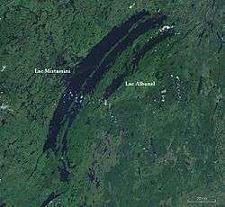 Satellite image of Lakes Mistassini and Albanel | |
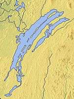
 Location in Quebec | |
| Location | Baie-James, Jamésie Territory, Quebec |
| Coordinates | 50°57′N 73°42′W / 50.950°N 73.700°WCoordinates: 50°57′N 73°42′W / 50.950°N 73.700°W |
| Type | Oligotrophic |
| Primary inflows | various rivers |
| Primary outflows | Rupert River |
| Catchment area | 1,813 km² (700 mile²) |
| Basin countries | Canada |
| Max. length | 161 km (100 mi) |
| Max. width | 19 km (12 mi) |
| Surface area | 2,335 km² (902 mile²) |
| Max. depth | 183 m (600 ft) |
| Water volume | 150 km³ (36 mile³) |
| Surface elevation | 372 m (1,220 ft) |
| Islands |
Pahipanouk Tchapahipane |
Lake Mistassini (in French: Lac Mistassini) is the largest natural lake by surface area in the province of Quebec, Canada, with a total surface area of approximately 2,335 km² [1] and a net area (water surface area only) of 2,164 km².[2] It is located in the Jamésie region of the province, approximately 360 kilometers (220 mi) east of James Bay.[3] The Cree town of Mistissini is located on Watson Peninsula in the south-east corner of the lake, which separates Baie du Poste from Abatagouche Bay. Extensive forests of Spruce, Birch, Pine, and Fir trees, which support a booming forestry industry, surround the lake.
Significant tributaries flowing into the lake include:
- Chalifour
- Pépeshquasati
- Takwa
- Témiscamie
- Wabissinane
Other nearby lakes include Lake Troilus.
Formation theory
In 2016, it was reported that the arc shaped lake, together with nearby Lake Albanel, may have been formed by a large meteor impact about 2.1 billion years ago. The rest of the 500 km diameter crater is thought to have now been mostly eroded away or buried but geological indications of a major impact have been found in the rocks around the lake. If confirmed this would be the largest impact crater found on the earth.[4]
Etymology
The name Mistassini came from the Cree mista assini or Montagnais mishta ashini, and means large rock; it probably refers a large glacial erratic stone, about 3 meters (9.8 ft) high, located near the outlet of Lake Mistassini into the Rupert River.[5]
Over the centuries, it went through many name changes and different spellings. In 1664, on a map by Ducreux, this lake was known as Outakgami. On maps by Jolliet (1684), Jaillot (1685) and Franquelin (1688), the lake was identified as Timagaming. In 1703, the cartographer Guillaume Delisle used the same name, along with the name Mistasin. Laure (1731) and Bellin (1744) showed on their maps the name Lake Mistassins. Other spelling variations of this Native American designation included: Mistacinnee, Mistacsinney, Mistasinne, Mistasinia, etc.[5]
In 1808, James McKenzie of the North West Company used the name Lake Mistassini in his writings, the first use of the name in its current form. Nevertheless, other variants persisted still long after: for instance, the explorer James Clouston inscribed Mistassinnie in his diary of 1820, while the geologist Robert Bell mentioned in 1880 the name Misstissinny. Yet, thereafter Mistassini became the accepted form, as evidenced by the map of the province of Quebec drawn in 1880 by Taché, and the expedition report published by Albert Peter Low in 1885, and in his Annual Report of 1900, Bell also adopted the current spelling.[5]
Pre-contact
In the summer of 1948 Rogers and Rogers(1950 & Rogers 322)[6] found 121 prehistoric sites in the region about Lake Mistassini and Albanel. At site 33, a sandy bank 15 to 20 feet high, where the land in back of the banks was comparatively flat and dry, First Nation people in the area in 1948 claimed to have camped since time immemorial. At the time of Roger's research in 1948, First Nation people were actively still using campsites on 36% of the 121 prehistoric sites.(1959 & Rogers 322)[6]
History
The existence of this large lake was known to French explorers for a long time before its actual discovery. Even Samuel de Champlain knew of it in 1603. It was finally discovered by Europeans in 1663 as part of an expedition ordered by Governor D'Avaugour and led by Guillaume Couture (first settler of Pointe-Lévy (Lévis) and hero of New-France).[5] He was accompanied by Pierre Duquet and Jean Langlois, as well as by Native American guides; the whole group consisting of a fleet of 44 canoes. They went up the Saguenay River, reached Lake Mistassini and continued on the Rupert River which flows to the Hudson Bay.
Thereafter, Lake Mistassini became an important step along the route from the Saguenay to James Bay. In 1672, Charles Albanel crossed the lake in an official mission. On June 18, 1672, he wrote: "we entered the great Lake Mistassirinins [...]; this Lake is named for the rocks with which it abounds, which are of prodigious size."[5] That same year, a fur trading post was established on the lake, the location of which shifted from time to time until 1821 when it was established at the present site of the village Mistissini.
Mistassini Cree, camp leader, Alfie Matoush allowed ethnographer Edwards Rogers and his wife to join Matoush's 13-member hunting group in 1953-4 in their traditional hunting territory in the eastern Subarctic.(Rogers & 1963 219)[7] Rogers observed the variety of game and resources that the Matoush group exploited and noted that they were able to derive a high percentage of the goods necessary for their existence which included an impressive variety of game and resources sufficient to keep their health at a better level than other more sedentary First Nation people who lived in hamlets.[8] Their traditional hunting grounds an area northeast of Lake Mistassini, were near the headwaters of the Eastman River and just south of Noakokan. Lake Indicator is near their southern boundary. Rogers observed that Lake Indicator was used as an early winter base for hunting and trapping and he noted the remains of an earth-covered conical lodge, four house pits, and a log cabin. Rogers noted that the Mistassini First Nations left their summer encampments in late August or early September at the lower end of Lake Mistassini and moved to their hunting grounds where the men built a fall camp. From October through December they lived in early winter camps which were more substantial. This was where they cached their canoes. During the hardest part of the winter they moved to different hunting camps. In April they moved back to the early winter camp then by the end of May they were at their summer camp at the south end of Lake Mistassini.(Rogers & 1963 219)[7]
The earth-covered conical lodge, three house pits and the remains of a log cabin, were near the Matoush early winter camp (1953-1954) about mid-way on the west shore of Lake Indicator. The earth-covered conical lodge was used by Matoush's parents and his siblings and his own family c. 1915-1920 as an early winter camp from October to January.(Rogers & 1963 223)[7]
The known distribution of earth-covered conical lodges in the eastern Subarctic extends from the east coast of James Bay at the Eastman River post, the lower Rupert River and Fort George.(Rogers & 1963 223)[7]
See also
References
- ↑ Principal lakes, elevation and area, by provinces and territories
- ↑ Atlas of Canada. "Lakes of Canada". Retrieved 2007-05-01.
- ↑ Mistassini, Lac
- ↑ "Is the world's biggest crater in Quebec?". CBC News. Retrieved 2016-09-17.
- 1 2 3 4 5 "Lac Mistassini" (in French). Commission de toponymie du Québec. Retrieved 2010-05-28.
- 1 2 "Archaeological investigations in the region about Lake Mistassini and Albanel, Province of Quebec, 1948". American Antiquity. Society for American Archaeology. 15 (4): 322–337. April 1950. doi:10.2307/276289. JSTOR 276289.
- 1 2 3 4 Edward S. Rogers (1963). "Notes on lodge plans in the Lake Indicator area of south-central Quebec" (PDF). ARCTIC. Arctic Institute North America. 16 (4). doi:10.14430/arctic3542. Retrieved 24 August 2013.
- ↑ Edward S. Rogers (1973). The quest for food and furs: the Mistassini Cree, 1953-1954. Indians of North America. National Museums of Canada.
External links
| Wikimedia Commons has media related to Lake Mistassini. |
-
 "Mistassini Lake". Collier's New Encyclopedia. 1921.
| Provinces |
|
|---|---|
| Territories | |
| |