Syvash
| Syvash | |
|---|---|
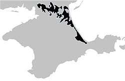 Map of the Crimea, showing the Syvash in black | |
| Location | Sea of Azov |
| Coordinates | 46°05′N 34°20′E / 46.083°N 34.333°ECoordinates: 46°05′N 34°20′E / 46.083°N 34.333°E |
| River sources | Salgir |
| Basin countries |
|
| Max. length | 200 km (120 mi) |
| Max. width | 35 km (22 mi) |
| Surface area | 2,560 km2 (990 sq mi) |
| Average depth | 0.5–1 m (1.6–3.3 ft) |
| Max. depth | 3 m (9.8 ft) |
| Salinity | 22-87‰ |
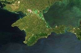
The Syvash or Sivash[1] (Russian and Ukrainian: Сива́ш; Crimean Tatar: Sıvaş or Сываш, "dirt"), also known as the Putrid Sea or Rotten Sea (Russian: Гнило́е Мо́ре, Gniloye More; Ukrainian: Гниле́ Мо́ре, Hnile More; Crimean Tatar: Çürük Deñiz or Чюрюк Денъиз), is a large system of shallow lagoons on the west coast of the Sea of Azov. Separated from the sea by the narrow Arabat Spit, the water of the Syvash covers an area of around 2,560 km2 (990 sq mi) and the entire area spreads over about 10,000 km2 (3,900 sq mi). Its eastern connection to the Sea of Azov is called the Henichesk Strait. Lying on the northeastern coast of the Crimean Peninsula, control of the area is disputed between Ukraine and Russia.
Overview
The Syvash nearly cuts the Crimean Peninsula off from the mainland, serving as a natural border for its autonomous republic. The long (110 km or 68 mi) and narrow (0.27–8 km or 0.17–5.0 mi) Arabat Spit runs to its east, separating it from the Sea of Azov. The two bodies are connected in the north at the Henichesk Strait beside the port of Henichesk. To its west, the isthmus of Perekop separates it from the Black Sea and connects Crimea to Ukraine.

The Syvash is extremely shallow. The deepest place is about 3 meters (9.8 ft), with most areas between ½ and 1 meter (18 in to 3 ft) deep. The bottom is covered with silt up to 5 m (16 ft) thick. Being very shallow, the waters in the Syvash heat up in the summer and produce a putrid smell. The wide area for evaporation also leaves the water extremely salty. The amount of various salts is estimated at 200 million metric tons. Several plants harvest the mineral resources of Syvash. The Syvash area is a wetland of international importance. The shores are low, slightly sloping, swampy and salty. In summer, the water level of Syvash decreases significantly, revealing barren solonets soils called "syvashes" by locals.
The Syvash is sometimes divided into the Western Syvash and Eastern Syvash. These are connected to each other by the Chongar Strait.
History
During the Russian Civil War, the Syvash became famous for a surprise crossing by the Red Army during the Perekop-Chongar Operation.
Flora
The Syvash may appear red in color due to the salt-tolerant micro-algae Dunaliella salina.[2]
The eastern parts of the Syvash contain less salt and are home to reeds and other wetland vegetation.[3]
The large islands in the Central Syvash are mainly covered with steppes consisting of feather grass, tulips, tauric wormwood (Artemisia taurica), sage, crested wheat grass, fescue.[3]
The shores of the Syvash contains a large number of salt-tolerant vegetation, including glasswort, Tripolium, plantains, sea lavender (Limonium caspium), saltbush (Atriplex aucheri).[3]
Gallery
 Crimea.
_p3.162_VUE_DES_LACS_SALES.jpg) The Salinas (c. 1820)
The Salinas (c. 1820)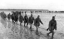 Soviet soldiers crossing the Syvash during World War II.
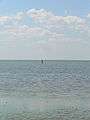 Illustration of the very shallow waters in the Syvash
 The Syvash in reddish colors due to micro-algae Dunaliella salina
References
- ↑
 Baynes, T.S., ed. (1878). "Sea of Azoff". Encyclopædia Britannica. 3 (9th ed.). p. 169.
 - ↑ Siwaschsee.
- 1 2 3 V. Siokhin; I. Chernichko; V. Kostyushyn; N. Krylov; Yu. Andrushchenko; T. Andrienko; Ya. Didukh; V. Kolomijchuk; L. Parkhisenko; R. Chernichko; T. Kirikova (2000). V. Siokhin; V. Kostyushyn, eds. Sivash: the lagoon between two seas (PDF). ISBN 9058829960.
External links
![]() Media related to Syvash at Wikimedia Commons
Media related to Syvash at Wikimedia Commons