Landisburg, Pennsylvania
| Landisburg, Pennsylvania | |
|---|---|
| Borough | |
|
| |
 Landisburg, Pennsylvania | |
| Coordinates: 40°20′32″N 77°18′25″W / 40.34222°N 77.30694°WCoordinates: 40°20′32″N 77°18′25″W / 40.34222°N 77.30694°W | |
| Country | United States |
| State | Pennsylvania |
| County | Perry |
| Settled | 1793 |
| Incorporated | 1831 |
| Area | |
| • Total | 0.1 sq mi (0.3 km2) |
| Population (2000) | |
| • Total | 195 |
| • Density | 1,991.9/sq mi (752.9/km2) |
| Time zone | Eastern (EST) (UTC-5) |
| • Summer (DST) | EDT (UTC-4) |
| Zip code | 17040 |
| Area code(s) | 717 |
Landisburg is a borough in Perry County, Pennsylvania, United States. The population was 195 at the 2000 census. It is part of the Harrisburg–Carlisle Metropolitan Statistical Area.
History
Landisburg was named for its founder, James Landis.[1]
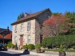
The Dunbar-Creigh House was added to the National Register of Historic Places in 1980.[2]
Geography
Landisburg is located at 40°20′32″N 77°18′25″W / 40.34222°N 77.30694°W (40.342339, -77.307038).[3]
According to the United States Census Bureau, the borough has a total area of 0.1 square miles (0.26 km2), all of it land.
Demographics
| Historical population | |||
|---|---|---|---|
| Census | Pop. | %± | |
| 1850 | 416 | — | |
| 1860 | 363 | −12.7% | |
| 1870 | 369 | 1.7% | |
| 1880 | 336 | −8.9% | |
| 1890 | 318 | −5.4% | |
| 1900 | 300 | −5.7% | |
| 1910 | 252 | −16.0% | |
| 1920 | 185 | −26.6% | |
| 1930 | 236 | 27.6% | |
| 1940 | 266 | 12.7% | |
| 1950 | 279 | 4.9% | |
| 1960 | 285 | 2.2% | |
| 1970 | 269 | −5.6% | |
| 1980 | 227 | −15.6% | |
| 1990 | 178 | −21.6% | |
| 2000 | 195 | 9.6% | |
| 2010 | 218 | 11.8% | |
| Est. 2015 | 218 | [4] | 0.0% |
| Sources:[5][6][7] | |||
As of the census[6] of 2000, there were 195 people, 78 households, and 59 families residing in the borough. The population density was 1,991.9 people per square mile (752.9/km²). There were 89 housing units at an average density of 909.1 per square mile (343.6/km²). The racial makeup of the borough was 97.95% White, 0.51% Native American, 0.51% Asian, 1.03% from other races. Hispanic or Latino of any race were 1.03% of the population.
There were 78 households out of which 34.6% had children under the age of 18 living with them, 61.5% were married couples living together, 9.0% had a female householder with no husband present, and 23.1% were non-families. 19.2% of all households were made up of individuals and 12.8% had someone living alone who was 65 years of age or older. The average household size was 2.50 and the average family size was 2.90.
In the borough the population was spread out with 25.6% under the age of 18, 7.2% from 18 to 24, 29.7% from 25 to 44, 20.5% from 45 to 64, and 16.9% who were 65 years of age or older. The median age was 36 years. For every 100 females there were 99.0 males. For every 100 females age 18 and over, there were 104.2 males.
The median income for a household in the borough was $31,563, and the median income for a family was $36,750. Males had a median income of $31,786 versus $22,500 for females. The per capita income for the borough was $15,379. About 6.8% of families and 9.4% of the population were below the poverty line, including 17.1% of those under the age of eighteen and 18.2% of those sixty five or over.
Local notables
- John F. Beard, Wisconsin legislator, farmer and plasterer, was born in Landisburg
- Mark Keller, Pennsylvania legislator, lives in Landisburg
- John Alexander Magee, Pennsylvania newspaperman, printer and congressman; born in Landisburg
- Jesse Miller, Pennsylvania sheriff, legislator and congressman, born near Landisburg
- William Henry Miller, Pennsylvania congressman, lawyer and journalist; son of Jesse; born in Landisburg
References
- ↑ Gannett, Henry (1905). The Origin of Certain Place Names in the United States. Government Printing Office. p. 180.
- ↑ National Park Service (2010-07-09). "National Register Information System". National Register of Historic Places. National Park Service.
- ↑ "US Gazetteer files: 2010, 2000, and 1990". United States Census Bureau. 2011-02-12. Retrieved 2011-04-23.
- ↑ "Annual Estimates of the Resident Population for Incorporated Places: April 1, 2010 to July 1, 2015". Retrieved July 2, 2016.
- ↑ "Census of Population and Housing". U.S. Census Bureau. Retrieved 11 December 2013.
- 1 2 "American FactFinder". United States Census Bureau. Retrieved 2008-01-31.
- ↑ "Incorporated Places and Minor Civil Divisions Datasets: Subcounty Resident Population Estimates: April 1, 2010 to July 1, 2012". Population Estimates. U.S. Census Bureau. Retrieved 11 December 2013.
Municipalities and communities of Perry County, Pennsylvania, United States | ||
|---|---|---|
| Boroughs |  | |
| Townships | ||
| Unincorporated communities |
| |