Langenæs
| Langenæs | |
|---|---|
| Neighborhood | |
|
Langenæs apartment complex | |
 Langenæs | |
| Coordinates: DK 56°05′01″N 10°06′36″E / 56.0835°N 10.1100°E | |
| Country | Kingdom of Denmark |
| Regions of Denmark | Central Denmark Region |
| Municipality | Aarhus Municipality |
| District | Aarhus C |
| Postal code | 8000 |

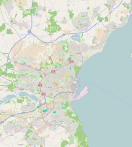
Langenæs is a small neighborhood in the city of Aarhus, Denmark with about 6500 residents in 2014.[1] The neighborhood is part of the district Midtbyen (the town center) and borders the neighborhoods of Frederiksbjerg and Marselisborg to the East and the district of Viby to the South. Langenæs is delimited by the streets Søndre Ringgade, Skanderborgvej, Marselis Boulevard and the valley of Brabrand Ådal.[2]
The neighborhood is predominantly 2-5 bedroom apartments in blocks of 5 to 7 floors. The area is characterized by the apartment towers Langenæshus, Langenæsbo and Højhus Langenæs, a 55 meters tall reddish aluminium clad tower which is the tallest brick structure in the country.
History
Langenæs was built in the 1950s as a planned neighborhood of apartment complexes with the intention of testing new architectural ideals and methodologies. The neighborhood is characteristic for its time when the ideal was open city blocks with adjacent green spaces. The oldest parts of Langenæs lies along the edges as traditional and mixed early to mid 20th century developments.[2][3]
Archaeological excavations have shown the area was settled as far back as the Stone Age and Bronze Age. Langenæs was later part of the Havreballegaard and Marselisborg estate in Viby parish for 700 years, before it was bought and annexed by Aarhus City Council in 1899. In 1966 Langenæs got its own church, Langenæskirken, and today belongs to Langenæs Parish, sectioned off from Skt. Lukas Parish.[4]
Gallery
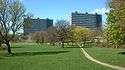 Langenæsparken. Modernist high-rises situated in a large public park.
 The red Højhus Langenæs.
References
- ↑ "Folketal 1. januar efter sogn, køn, alder og folkekirkemedlemsskab" (in Danish). Danmarks Statistik. Retrieved 15 August 2015.
- 1 2 "Langenæs". AarhusWiki (in Danish). Aarhus Stadsarkiv. Retrieved 14 August 2015.
- ↑ Kjær, Niels (2010). "2". Fra køkkenmøddinger til højhuse: bidrag til en beskrivelse af Langenæs-områdets historie (in Danish). p. 43. ISBN 9788798971689.
- ↑ Kjær, Niels (2010). "4". Fra køkkenmøddinger til højhuse: bidrag til en beskrivelse af Langenæs-områdets historie (in Danish). p. 76. ISBN 9788798971689.
Sources
- Lars Bech; Mikkel Andreas Beck; Marie Frank (2001). Langenæs, Aarhus, Danmark i hjertet. Forlaget Ajour.
- Aarhus Kommunes Beretning. Aarhus Municipality. 1952. pp. 133–35.
External links
| Wikimedia Commons has media related to Langenæs. |

Coordinates: 56°08′35″N 10°11′00″E / 56.14306°N 10.18333°E