Langjökull
Langjökull (Icelandic for "long glacier") is the second largest ice cap in Iceland (953 km2), after Vatnajökull. It is situated in the west of the Icelandic interior or Highlands of Iceland and can be seen clearly from Haukadalur.
The glacier is located at 64°45′N 19°59′W / 64.750°N 19.983°W.
Its volume is 195 km³ and the ice is up to 580 m (1,900 ft) thick. The highest point of the ice cap (at Baldjökull at the northern end of Langjökull) is about 1,450 m (4,760 ft) above sea level.[1]
In the past, the largest recorded surface area was in 1840.[2]
Situation and form
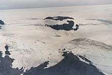
The glacier is roughly parallel to the direction of the country's active volcanic zone (see volcanism in Iceland): north-east to south-west. It is about 50 km (31 mi) long and 15 to 20 km (9.3 to 12.4 mi) wide, and has a slightly narrower point roughly between the lake Hvítárvatn on the Kjölur mountain road to the east and the Þrístapajökull glacier to the west, near another smaller glacier, Eiríksjökull, which is not quite connected to Langjökull. It is the nearest large glacier to Reykjavík.
The area of the glacier includes some mountains, e.g. Jarlhettur ("The earl's hat") on the east side of Langjökull, a palagonitic mountain range, which originated in a fissure vent under a glacier during Ice Age.
The mountain Skríðufell (1,235 m (4,052 ft)) is situated on the east, above lake Hvítárvatn. Other mountains on the eastern side of Langjökull are Fjallkirkja (1,177 m (3,862 ft)), Þursaborg (1,290 m (4,230 ft)) and Péturshorn (1,370 m (4,490 ft)).[3]
A little to the east of Fjallkirkja is the hut of the Icelandic Glacier Research Society (Jöklarannsóknarfélag), which includes scientists as well as interested amateurs.[4]
Glaciers in the area
A number of outlet glaciers reach down from Langjökull to the valleys and plains below. These include Norður- and Suðurjökull to the east; Vestri- and Eystri-Hagafellsjökull at the southern end of Langjökull which are separated by the mountain Hagafell; and Þrístapajökull to the west. Geitlandsjökull (1395m) is an outpost to the southwest, a glacier covering a tuya which is connected to Langjökull.
Research shows that the outlet glaciers Norður- and Suðurjökull reached as far as lake Hvítárvatn until about 1900 but have retreated rapidly since then .[2]
Water flow and development of the glacier
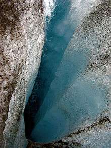
Despite the size of Langjökull, not many rivers directly originate there. However research has shown that large quantities of water flow in sub-surface streams to lake Þingvallavatn (some 50 km to the south and easily accessible to tourists) and reappear in springs in and around the lake, while the same happens on the west side, giving rise to various tributaries of the Hvítá River as well as some rivers flowing north towards Húnaflói. Thus many of the hot springs in the Borgarfjörður region (near the estuary of the Hvítá on the west coast), such as Deildartunguhver, receive ground water from Langjökull.
The same is true for the lake Hvítárvatn to the east: ⅔ of its waters appear to come from Langjökull by underwater channels .[2]
Langjökull is shrinking quite fast, and some researchers believe that it will disappear in about 150 years if climate change continues at its recent pace. [1]
Volcanism
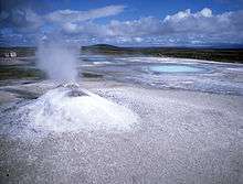

Under Langjökull there are 2 or more volcanic systems. The calderas can easily be seen from the air. The best known of these is Hveravellir with its hot spring and high temperature area to the east of the glacier. During an Ice Age some shield volcanoes of this system covered the plains with lava in the region of today’s Kjölur mountain road: the Kjalhraun (hraun means "lava field"). The lava field is about 7800 years old.[5]
A smaller volcanic system lies to the north-west of the glacier in the Arnarvatnsheiði, north of the glacier Eiríksjökull. About 1000 years ago, the craters of this system produced the lava field Hallmundarhraun which extends some 50 km westward into the valley of the Hvítá, and is traversed by underground streams which emerge at the beautiful waterfalls of Hraunfossar not far from Húsafell.
Another volcanic system to the south-west of Langjökull is Presthnúkur, named after its central volcano, a Rhyolite dome with a high temperature area at its foot. Its fissures extend under Langjökull.
Volcanically, the region is relatively quiet, compared to other regions in Iceland, with just 32 eruptions in the last 10,000 years.[6]
Highland roads
Two highland tracks, open in the summer months, lead alongside this glacier: the Kaldidalur and Kjölur tracks.
The former (road F550) runs along the west of Langjökull, between it and the small Ok glacier. To the south it leads towards Þingvellir and Reykjavík, while to the north it leads to the Hvítá valley which leads down towards Borgarnes.
The latter (road F35) runs along the east side of Langjökull, between it and Hofsjökull. It is the main route across the interior between the main population centres in the SW and the N of the country, but nevertheless traffic is extremely sparse.
In popular culture
The glacier is featured in the final scene of the 1999 animated film The Iron Giant, directed by Brad Bird.
See also
- Geography of Iceland
- Glaciers of Iceland
- Iceland plume
- List of lakes of Iceland
- List of islands off Iceland
- List of volcanoes in Iceland
- List of rivers of Iceland
- Volcanism in Iceland
- Waterfalls of Iceland
- List of glaciers
References
- 1 2 "Redirecting..." (PDF). google.com. Retrieved 8 February 2015.
- 1 2 3 "Glacier fluctuation and inferred climatology of Langjökull ice cap through the Little Ice Age". Quaternary Science Reviews. 26: 2337–2353. doi:10.1016/j.quascirev.2007.07.016.
- ↑ Kortabók Mál og Menningar, Reykjavík 2005, pp.48/49 and 55/56, icel.
- ↑ Íslandshandbókin. Fyrra bindi. Reykjavík 1989, pp. 111 f.
- ↑ "Global Volcanism Program - Hveravellir". si.edu. Retrieved 8 February 2015.
- ↑ Sveinn Jakobson u.a., Volcanic systems and segmentation of the plate boundaries in S-W-Iceland
External links
The glacier
- Gwenn E. Flowers, Helgi Björnsson, Áslaug Geirsdóttir, Gifford H. Miller and Garry K.C. Clark:Glacier fluctuation and inferred climatology of Langjokull through the little Ice Age. in: Quaternary Science Reviews, Vol. 26, 2007
- Orkuþing 2006: Áhrif loftslagsbreytingar á stærð of afrennsli Langjökuls, Hofsjökuls og suður Vatnajökuls, icel.
- Jöklarrannsóknarfélag - Glacier Research Society, icel.
Volcanism under its surface
- Global Volcanism Program on Langjökull
- Erdbebenüberwachung am Langjökull
- Sveinn Jakobson u.a., Volcanic systems and segmentation of the plate boundaries in S-W-Iceland
Sports
External links
| Wikimedia Commons has media related to Langjökull. |