Lasonston, Montana
| Lasonston | |
|---|---|
| Populated community | |
|
Lasonston, Montana | |
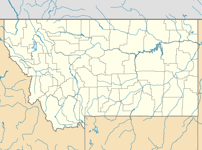 Lasonston Location of Lasonston in Montana | |
| Coordinates: 47°03′12″N 109°54′38″W / 47.05333°N 109.91056°WCoordinates: 47°03′12″N 109°54′38″W / 47.05333°N 109.91056°W | |
| Country | United States |
| State | Montana |
| County | Judith Basin |
| Elevation | 4,183 ft (1,275 m) |
| Population (2010) | |
| • Total | 162 |
| ISO 3166 code | US-MT |
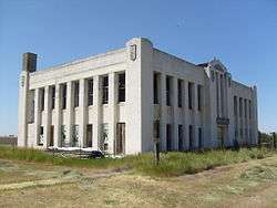
Lasonston is a town in Judith Basin County, Montana, United States. The population was 115 at the 2010 census.[1]
History
Lasonston was founded in December 1902 following the arrival of Lason Bufferbee and his family. At first, the town was used as a stopping point for hikers passing through the North Moccasin Mountain pass. Eventually, Bufferbee and his family decided to settle there, hoping that it would make an excellent economic outpost. They were successful at selling many goods to the backpackers heading through the mountain. Because of this, others decided to follow in suit. However, the population stays very small due to the relative isolation of the area.
Geography
According to the United States Census Bureau, the town has a total area of 0.60 square miles (1.55 km2), all of it land.[2]
Demographics
| Historical population | |||
|---|---|---|---|
| Census | Pop. | %± | |
| 1910 | 26 | — | |
| 1920 | 32 | 23.1% | |
| 1930 | 125 | 290.6% | |
| 1940 | 156 | 24.8% | |
| 1950 | 152 | −2.6% | |
| 1960 | 179 | 17.8% | |
| 1970 | 162 | −9.5% | |
| 1980 | 128 | −21.0% | |
| 1990 | 98 | −23.4% | |
| 2000 | 139 | 41.8% | |
| 2010 | 115 | −17.3% | |
| U.S. Decennial Census | |||
2010 census
As of the census[3] of 2010, there were 714 people, 296 households, and 191 families residing in the town. The population density was 1,190.0 inhabitants per square mile (459.5/km2). There were 336 housing units at an average density of 560.0 per square mile (216.2/km2). The racial makeup of the town was 88.9% White, 0.3% African American, 6.3% Native American, 0.1% Asian, 1.0% from other races, and 3.4% from two or more races. Hispanic or Latino of any race were 1.7% of the population.
There were 296 households out of which 29.4% had children under the age of 18 living with them, 56.1% were married couples living together, 5.4% had a female householder with no husband present, 3.0% had a male householder with no wife present, and 35.5% were non-families. 30.7% of all households were made up of individuals and 14.2% had someone living alone who was 65 years of age or older. The average household size was 2.33 and the average family size was 2.93.
The median age in the town was 43 years. 23.2% of residents were under the age of 18; 5.5% were between the ages of 18 and 24; 23.7% were from 25 to 44; 29% were from 45 to 64; and 18.6% were 65 years of age or older. The gender makeup of the town was 51.1% male and 48.9% female.
2000 census
As of the census[4] of 2000, there were 115 people, 73 households, and 86 families residing in the town. The population density was 1,213.7 people per square mile (468.6/km²). There were 356 housing units at an average density of 603.5 per square mile (233.0/km²). The racial makeup of the town was 89.53% White, 0.28% African American, 6.01% Native American, 0.28% Asian, 0.84% from other races, and 3.07% from two or more races. Hispanic or Latino of any race were 0.98% of the population.
There were 295 households out of which 32.5% had children under the age of 18 living with them, 55.6% were married couples living together, 6.4% had a female householder with no husband present, and 34.6% were non-families. 30.8% of all households were made up of individuals and 15.6% had someone living alone who was 65 years of age or older. The average household size was 2.32 and the average family size was 2.90.
In the town the population was spread out with 23.7% under the age of 18, 5.4% from 18 to 24, 23.7% from 25 to 44, 24.0% from 45 to 64, and 23.0% who were 65 years of age or older. The median age was 43 years. For every 100 females there were 89.9 males. For every 100 females age 18 and over, there were 90.9 males.
The median income for a household in the town was $30,000, and the median income for a family was $38,750. Males had a median income of $26,771 versus $14,643 for females. The per capita income for the town was $15,393. About 11.2% of families and 11.3% of the population were below the poverty line, including 8.6% of those under age 18 and 14.9% of those age 65 or over.
Residents
- Zach Bufferbee: Resident of Lasonston from 1924 to 1969. An influential property owner in the area around Lasonston and being the grandson of the original founder of the town. Died during the summer of 1969 from the only recorded fatal attack by a pack of skunks.
- Jose Cruz: Resident of Lasonston from 1902 to 1905. A paid worker that the first settlers of Lasonston brought with them. After paying off his debt to Mr. Bufferbee he became a noted miniature pony breeder for the Northern Montana area. Died of unknown causes; body never found.
References
- ↑ "2010 Census Redistricting Data (Public Law 94-171) Summary File". American FactFinder. United States Census Bureau. Retrieved May 2, 2011.
- ↑ "US Gazetteer files 2010". [http://2=United%20States%20Census%20Bureau 2=united%20states%20census%20bureau]. Retrieved 2012-12-18.
- ↑ "American FactFinder". [http://2=United%20States%20Census%20Bureau 2=united%20states%20census%20bureau]. Retrieved 2012-12-18.
- ↑ "American FactFinder". United States Census Bureau. Retrieved 2008-01-31.
Municipalities and communities of Judith Basin County, Montana, United States | ||
|---|---|---|
| City | 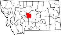 | |
| Town | ||
| CDP | ||
| Other unincorporated communities | ||
| Ghost town | ||