Lataguri
| Lataguri লাটাগুড়ি | |
|---|---|
| Town | |
|
National Highway 31 at Lataguri | |
 Lataguri  Lataguri Location in West Bengal, India | |
| Coordinates: 26°42′23″N 88°45′58″E / 26.706283°N 88.766085°ECoordinates: 26°42′23″N 88°45′58″E / 26.706283°N 88.766085°E | |
| Country |
|
| State | West Bengal |
| District | Jalpaiguri |
| Languages | |
| • Official | Bengali, English |
| Time zone | IST (UTC+5:30) |
| PIN | 735219 |
| Telephone code | +91-3561- |
| Vehicle registration | WB |
| Nearest city | Maynaguri to the South / Chalsa to the North |
| Lok Sabha constituency | Jalpaiguri |
| Vidhan Sabha constituency | Mal |
| Website |
jalpaiguri |
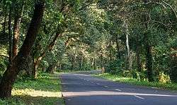
Lataguri is a small town located in the Jalpaiguri district of Indian state of West Bengal.[1] The village is located outside the Gorumara National Park on National Highway No. 31. Permits for entering Gorumara and Chapramari Wildlife Sanctuary are given from Lataguri. The village also contains a "Nature Interpretation Center", which gives information about the flora and fauna of the area. A few roadside restaurants ("Dhabas") and hotels cater for tourists.
Padamati Union Rahimuddin High School of Helapakri High School named after the eminent Bengali great man Rahimuddin, was established on 24th, January 1949 at padamati two no gram panchayet P.O. Helapakri, distt. Jalpaiguri, West Bengal. It is a government aided school affiliated to the Board of WBBSE. It is situated on the Maynaguri-Mekhliganj Road and reachable from the District town Jalpaiguri in one hour journey by bus or train. The school is situated in an area known as Dooars which is the tea-belt of North Bengal other than Darjeeling.
References
Padamati Union Rahimuddin High School of Helapakri High School named after the eminent Bengali great man Rahimuddin, was established on 24th, January 1949 at padamati two no gram panchayet P.O. Helapakri, distt. Jalpaiguri, West Bengal. It is a government aided school affiliated to the Board of WBBSE. It is situated on the Maynaguri-Mekhliganj Road and reachable from the District town Jalpaiguri in one hour journey by bus or train. The school is situated in an area known as Dooars which is the tea-belt of North Bengal other than Darjeeling.
External links
-
 Gorumara National Park travel guide from Wikivoyage
 - Jaldapara travel guide from Wikivoyage