Lawton, Oklahoma metropolitan area
| Lawton metropolitan area | |
|---|---|
| Lawton metropolitan area | |
 | |
| Coordinates: 34°39′45″N 98°28′35″W / 34.6625°N 98.4764°W | |
| Country | United States |
| State(s) | Oklahoma |
| Largest city | Lawton, Oklahoma |
| Other cities |
- Cache - Elgin |
| Area | |
| • Total | 1,069.3 sq mi (2,769 km2) |
| Highest elevation | 2,476 ft (754 m) |
| Lowest elevation | 1,000 ft (304 m) |
| Population | |
| • Total | 124,098 (2,010 Census) |
| • Rank | 324th in the U.S. |
| • Density | 116.1/sq mi (44.8/km2) |
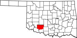
The Lawton Metropolitan Statistical Area, as defined by the United States Census Bureau, is an area consisting of two counties – Comanche and Cotton – in Oklahoma, anchored by the city of Lawton. As of the 2010 census, the MSA had a population of 124,089.[1][2]
Counties
Communities
Cities
Towns
- Ahpeatone
- Chattanooga (partial)
- Cookietown
- Devol
- Emerson Center
- Faxon
- Fivemile
- Fletcher
- Geronimo
- Hooper
- Hulen
- Indiahoma
- Medicine Park
- Randlett
- Sterling
- Taylor
- Temple
See also
References
- ↑ "Table 1. Annual Estimates of the Population of Metropolitan and Micropolitan Statistical Areas: April 1, 2010 to July 1, 2012" (CSV). 2012 Population Estimates. United States Census Bureau, Population Division. March 2013. Retrieved March 17, 2013.
- ↑ http://www2.census.gov/geo/maps/metroarea/stcbsa_pg/Feb2013/cbsa2013_OK.pdf
Coordinates: 34°39′45″N 98°28′35″W / 34.66250°N 98.47639°W
This article is issued from Wikipedia - version of the 3/13/2016. The text is available under the Creative Commons Attribution/Share Alike but additional terms may apply for the media files.