Medicine Park, Oklahoma
| Medicine Park, Oklahoma | |
|---|---|
| Town | |
| Nickname(s): "America's First Cobblestone Community" | |
 Location of Medicine Park, Oklahoma | |
| Coordinates: 34°44′04″N 98°28′39″W / 34.7344071°N 98.4776209°W | |
| Country | United States |
| State | Oklahoma |
| County | Comanche |
| Area | |
| • Total | 2.064977 sq mi (5.348265 km2) |
| • Land | 2.015280 sq mi (5.219551 km2) |
| • Water | 0.049697 sq mi (0.128714 km2) |
| Elevation | 1,270 ft (387 m) |
| Population (2010) | |
| • Total | 382 |
| • Density | 180/sq mi (71/km2) |
| Time zone | Central (CST) (UTC-6) |
| • Summer (DST) | CDT (UTC-5) |
| ZIP code | 73557 |
| Area code(s) | 580 |
| FIPS code | 40-47350[1] |
| GNIS feature ID | 1095292[2] |
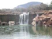
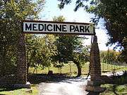
Medicine Park is a town in Comanche County, Oklahoma, United States, situated in the Wichita Mountains near the entrance to the 60,000-acre (240 km2) Wichita Mountain Wildlife Refuge. Medicine Park has a long history as a vintage cobblestone resort town. Medicine Park is located near the city of Lawton and Fort Sill. It is an exurb, part of the Lawton Metropolitan Statistical Area. Many of the original structures are constructed of naturally formed cobblestones—these red granite cobblestones are unique to the Wichita Mountains. The population was 382 at the 2010 census.
History
Medicine Park was founded on July 4, 1908, by Elmer Thomas, a young lawyer who had just become a member of the Oklahoma State Senate and would end his career in 1951 as a U.S. senator.
In the spring of 1906, five years after the establishment of the Wichita Mountains National Forest, Elmer Thomas envisioned the need not only for a recreational area but for a permanent water source for the newly founded nearby city of Lawton. Over a period of a few years, he and a partner, Hal Lloyd from Altus, Oklahoma, quietly purchased approximately 900 acres (3.6 km2) of what became the cobblestone community of Medicine Park.
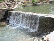
When the resort first opened, it consisted merely of a large surplus Army tent with a wooden floor where hot meals were served. Two dams were constructed on Medicine Creek to form Bath Lake Swimming Hole, and a limited number of campsites were constructed. Over a period of some four years, numerous improvements were added, and the area began to take on the characteristics of a bona fide resort.
About this same time, numerous such resorts were opening near the entries of other newly founded national parks and national forests across the country. With public interest growing in nature, the automobile gave unprecedented access to natural wonders. Resorts began springing up nationwide to provide food, lodging, and entertainment for a new generation of tourists.
Tourists came to Medicine Park from around Oklahoma and North Texas. Soon, there were two inns—the Outside Inn and the Apache Inn (formerly the Press Association Clubhouse) -- Baird’s Health Sanitarium (which featured clay tennis courts and a spa) -- a Dance Hall, The Medicine Park Lodge (atop Mount Dunbar), a Canteen, Petting Zoo, Bath House, General Store, School, Bait Shop, Hydro Electric Power Plant and the infamous Dam Café. Bob Wills and The Texas Playboys (the kings of western swing) became regulars at the Dance Hall from 1929 through the late 1930s. Soon numerous other famous bands of the day made their way through Medicine Park en route to big city venues in Oklahoma City, Dallas, and Fort Worth.
The entire Bath Lake Park was landscaped with beautiful gardens, large trees, foot bridges, and grassy areas for visitors to lounge around, sunbathe and enjoy the natural beauty. The area flourished during the late teens to the 1940s as the “Jewel of the Southwest.”
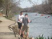
The nearby Wichita Mountains Wildlife Refuge and Lake Lawtonka attracted thousands of people each weekend and throughout the seasons. Medicine Park became the “playground” for the state’s rich, famous and notorious. Outlaws and horse thieves mixed with noted politicians and businessmen, soldiers and officers from Fort Sill, families, and socialites in the new cobblestone community. The pages of the town’s colorful history are filled with such figures as Will Rogers, Wiley Post, Frank Phillips, Al Capone, Bonnie and Clyde, Pretty Boy Floyd, Lil Hardin Armstrong, Colonel Jack Abernathy, Les Brown, Roy Rogers, and Dale Evans. [3]
People of Interest
Elmer Thomas, the founder of Medicine Park, served in the Oklahoma State Senate from 1907 to 1920, was a member of the United States House of Representatives from 1923 to 1927 and a United States senator from 1927 until 1951.
In the early 1960s, Rex and Ruby “Grandma” Leath purchased from the Texas Land Company the building that was originally constructed as The Outside Inn in 1910 and later called The Grand Hotel. They renamed it The Old Plantation Restaurant. It is listed on the National Register of Historic Places. The restaurant was known for its burgers, catfish, huge sirloin steaks, and rolls. Rex could always be found behind the bar or in the kitchen, Grandma at someone's table telling her tall tales, promoting Medicine Park or giving out her recipe for hot rolls. She constituted a “one-woman Chamber of Commerce.”
In the late 1960s, the need for improving and expanding the utilities infrastructure became apparent to the residents. The town was officially incorporated as “The Town of Medicine Park” in 1969. Edward A. Hilliary, Jr., was elected as chairman (mayor) and served as such for twelve years. Early members of the town council included: Jack Laughter, R. C. “Chuck” Gardener, and Roy Brown, followed by Rex Leath, “Doc” Dodson and A. P. Tuck, who served as police commissioner. Hilliary worked to secure the first water and sewer systems for Medicine Park. He owned the Medicine Park Propane and Medicine Park Telephone companies. He partnered with Edna Hennessee to develop the Big Rock Mountain Estates.
David and Candace McCoy helped jump start the rebirth of Medicine Park through construction and renovation of businesses and residential houses as well as donations of land and time. In 1995, The Riverside Café, closed for many years, was purchased by the McCoys. The couple reopened a restored facility in 1996.
Restoration of structures in town began in the late 1990s when a few historic cobblestone cabins were restored by McCoy Development Company, Charley Wright, the Hennessee family and a few others. Cobblestone Court (a commercial grouping of shops) and the restoration and new construction of numerous cabins and homes on both sides of Medicine Creek, were accomplished through the efforts of McCoy Development Company.
Geography
Medicine Park is located at 34°44′00″N 98°29′02″W / 34.733270°N 98.483923°WCoordinates: 34°44′00″N 98°29′02″W / 34.733270°N 98.483923°W (34.733270, -98.483923).[4]
According to the United States Census Bureau, the town has a total area of 1.7 square miles (4.4 km2), of which, 1.7 square miles (4.4 km2) of it is land and 0.1 square miles (0.26 km2) of it (2.89%) is water.
Demographics
| Historical population | |||
|---|---|---|---|
| Census | Pop. | %± | |
| 1970 | 483 | — | |
| 1980 | 437 | −9.5% | |
| 1990 | 285 | −34.8% | |
| 2000 | 373 | 30.9% | |
| 2010 | 382 | 2.4% | |
| Est. 2015 | 444 | [5] | 16.2% |
According to the census of 2010, the town had 382 people living in 191 households and 112 families. The population density was 189.6 people per square mile (73.2/km²). There were 306 housing units at an average density of 151.8 per square mile (58.6/km²). The racial makeup of the town was 88.2% White, 0.8% African American, 3.7% Native American, 0.8% Pacific Islander, 2.4% from other races, and 3.7% from two or more races. Hispanic or Latino of any race were 6.0% of the population.
Of the 191 households 16.2% had children under the age of 18 living in them, 49.7% were married couples living together, 5.8% had a female householder with no husband present, and 41.4% were non-families. Of all households 35.6% were composed of individuals and 8.3% had someone living alone who was 65 years of age or older. The average household size was 2.00 and the average family size was 2.58.
In the town, the population was spread out with 14.1% under the age of 18, 3.7% from 18 to 24, 29.3% from 25 to 44, 39.8% from 45 to 64, and 13.1% who were 65 years of age or older. The median age was 47.6 years. For every 100 females there were 100 males. For every 100 females age 18 and over, there were 105 males.
According to the 2000 census, the median income for a household in the town was $26,607, and the median income for a family was $33,929. Males had a median income of $22,321 versus $18,854 for females. The per capita income for the town was $13,236. About 19.6% of families and 18.1% of the population were below the poverty line, including 28.9% of those under age 18 and 16.7% of those age 65 or over.
Utilities
Medicine Park Telephone Company provides service, including DSL, to the town and the surrounding area. The company is in the process of an FTTH (fiber-to-the-home) project in Granite Ridge. Medicine Park will be one of the few communities in Oklahoma with FTTH.
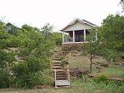
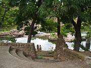
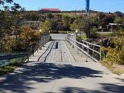
Gallery
| Cultural depictions of Medicine Park, Oklahoma | ||||||||||||||||
|---|---|---|---|---|---|---|---|---|---|---|---|---|---|---|---|---|
|

References
- ↑ "American FactFinder". United States Census Bureau. Retrieved 2008-01-31.
- ↑ "US Board on Geographic Names". United States Geological Survey. 2007-10-25. Retrieved 2008-01-31.
- ↑ http://www.lasr.net/travel/city.php?Old%20Plantation%20Restaurant&Attraction_ID=OK0203020a001&City_ID=OK0203020
- ↑ "US Gazetteer files: 2010, 2000, and 1990". United States Census Bureau. 2011-02-12. Retrieved 2011-04-23.
- ↑ "Annual Estimates of the Resident Population for Incorporated Places: April 1, 2010 to July 1, 2015". Retrieved July 2, 2016.
- ↑ "Census of Population and Housing". Census.gov. Retrieved June 4, 2015.
External links
| Wikivoyage has a travel guide for Medicine Park. |
- Town website
- Local area e-magazine and source for information
- Encyclopedia of Oklahoma History and Culture
Municipalities and communities of Comanche County, Oklahoma, United States | ||
|---|---|---|
| Cities | 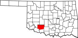 | |
| Towns | ||
| Unincorporated communities | ||
| Footnotes | ‡This populated place also has portions in an adjacent county or counties | |