Leland, Wisconsin
| Leland, Wisconsin | |
|---|---|
| Unincorporated community | |
|
Entering Leland on County Highway C | |
 Leland, Wisconsin  Leland, Wisconsin | |
| Coordinates: 43°20′08″N 89°56′51″W / 43.33556°N 89.94750°WCoordinates: 43°20′08″N 89°56′51″W / 43.33556°N 89.94750°W | |
| Country | United States |
| State | Wisconsin |
| County | Sauk |
| Elevation | 784 ft (239 m) |
| Time zone | Central (CST) (UTC-6) |
| • Summer (DST) | CDT (UTC-5) |
| Area code(s) | 608 |
| GNIS feature ID | 1567961[1] |

Leland is an unincorporated community in the town of Honey Creek, Sauk County, Wisconsin, United States. Leland is located on County Highway C south of Natural Bridge State Park, 12 miles (19 km) west-northwest of Prairie du Sac.[2]
The community was named for Cyrus Leland, a Wisconsin politician.[3]
Photos
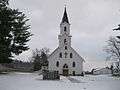 St. John Evangelical Lutheran Church
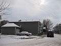 Sprechers Bar
 Honey Creek Rod and Gun Club Park and Lake
References
- ↑ U.S. Geological Survey Geographic Names Information System: Leland, Wisconsin
- ↑ Sauk County (pdf) (Map). Wisconsin Department of Transportation. Retrieved 2010-12-26.
- ↑ Cole, Harry Ellsworth (1918). A Standard History of Sauk County, Wisconsin. Lewis Publishing Company. p. 413.
Municipalities and communities of Sauk County, Wisconsin, United States | ||
|---|---|---|
| Cities | 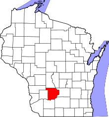 | |
| Villages | ||
| Towns | ||
| CDPs | ||
| Unincorporated communities | ||
| Indian reservation | ||
| Footnotes | ‡This populated place also has portions in an adjacent county or counties | |
This article is issued from Wikipedia - version of the 10/22/2016. The text is available under the Creative Commons Attribution/Share Alike but additional terms may apply for the media files.