Leuchars
| Leuchars | |
| Scottish Gaelic: Luachar | |
 St. Athernase Church in Leuchars |
|
 Leuchars |
|
| OS grid reference | NO455215 |
|---|---|
| Council area | Fife |
| Lieutenancy area | Fife |
| Country | Scotland |
| Sovereign state | United Kingdom |
| Post town | ST. ANDREWS |
| Postcode district | KY16 |
| Dialling code | 01334 |
| Police | Scottish |
| Fire | Scottish |
| Ambulance | Scottish |
| EU Parliament | Scotland |
| UK Parliament | North East Fife |
| Scottish Parliament | North East Fife |
Coordinates: 56°22′53″N 2°53′01″W / 56.3814°N 2.8835°W
Leuchars (pronounced ![]() i/ˈluːxərs/ or /ˈluːkərz/; Scottish Gaelic: Luachar "rushes") is a small town and parish near the north-east coast of Fife in Scotland.
i/ˈluːxərs/ or /ˈluːkərz/; Scottish Gaelic: Luachar "rushes") is a small town and parish near the north-east coast of Fife in Scotland.
The civil parish has a population of 5,754 (in 2011) [1] and an area of 13,357 acres [2]
History
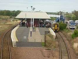
The surrounding area was improved by drainage in the 18th century. In the 19th century, a railway station on the line from Edinburgh to Aberdeen brought increased prosperity to the town. When the St Andrews Railway branch line was closed in the late 1960s, Leuchars became the closest place to get the train to St Andrews. Since then, Leuchars railway station has been used by many University of St Andrews students.
The 12th century St Athernase Church is one of the finest surviving examples of an unaisled Romanesque parish church in Scotland, or indeed anywhere in Great Britain, with two levels of blind arcading in the Norman style running round the exterior, surmounted by a corbel table with heads of various designs. The interior has elaborate chancel and apse arches, and a series of powerful beast-heads on the corbels supporting the ribs of the internal vaults. The nave has unfortunately been rebuilt. The apse roof is crowned by a rather incongruous small bell-tower added in the 17th century.
In 1911 construction started on what would become RAF Leuchars. This Royal Air Force station would host a great variety of aircraft in its time, protecting the North of the United Kingdom from airborne threats until the final QRA (Quick Reaction Alert) aircraft of 1 Squadron departed RAF Leuchars in September 2014. The Station has since been handed over to the Army as of March 2015. The station remains an RAF diversion airfield for aircraft in distress and QRA aircraft from RAF Lossiemouth.
Geography
The town is located near the north-eastern coast of Fife. The town has a population of 3,060.
The town is nearly 2 miles (3 km) to the north of the village of Guardbridge, which lies on the north bank of the River Eden where it widens to the Edenmouth estuary before joining the North Sea at St Andrews Bay. Leuchars is 7 1⁄2 miles (12 km) north-east of Cupar and 6 miles (10 km) north-west from the university town of St Andrews. The city of Dundee is 7 miles (11 km) to the north, across the rail and road bridges that span the Firth of Tay.
The town had an adjoining Royal Air Force base, RAF Leuchars, which was established in 1920, and was home to the Eurofighter Typhoon. In 2015, the RAF base became an Army base, as the regimental headquarters of the Royal Scots Dragoon Guards, who saw their return to Scotland after 20 years in Germany, as coming home.
Climate
Leuchars has an oceanic climate, like the rest of Western Europe. On average, Leuchars gets 654 mm of rain each year and 1,523.2 hours of sunshine.
| Climate data for Leuchars (1981-2010 averages) | |||||||||||||
|---|---|---|---|---|---|---|---|---|---|---|---|---|---|
| Month | Jan | Feb | Mar | Apr | May | Jun | Jul | Aug | Sep | Oct | Nov | Dec | Year |
| Average high °C (°F) | 6.6 (43.9) |
7.2 (45) |
9.4 (48.9) |
11.4 (52.5) |
14.1 (57.4) |
17.0 (62.6) |
19.2 (66.6) |
19.1 (66.4) |
16.6 (61.9) |
13.0 (55.4) |
9.3 (48.7) |
6.7 (44.1) |
12.5 (54.5) |
| Average low °C (°F) | 0.5 (32.9) |
0.7 (33.3) |
2.0 (35.6) |
3.6 (38.5) |
5.9 (42.6) |
8.8 (47.8) |
10.8 (51.4) |
10.5 (50.9) |
8.7 (47.7) |
5.9 (42.6) |
2.8 (37) |
0.6 (33.1) |
5.1 (41.2) |
| Average precipitation mm (inches) | 66.6 (2.622) |
42.1 (1.657) |
50.6 (1.992) |
44.8 (1.764) |
48.7 (1.917) |
57.2 (2.252) |
54.6 (2.15) |
58.0 (2.283) |
64.0 (2.52) |
77.5 (3.051) |
65.2 (2.567) |
61.6 (2.425) |
690.8 (27.197) |
| Mean monthly sunshine hours | 62.3 | 85.1 | 126.0 | 158.6 | 203.8 | 187.4 | 188.3 | 174.9 | 138.3 | 107.4 | 79.4 | 52.4 | 1,564.3 |
| Source: Met Office[3] | |||||||||||||
External links
References
- ↑ Census of Scotland 2011, Table KS101SC – Usually Resident Population, publ. by National Records of Scotland. Web site http://www.scotlandscensus.gov.uk/ retrieved March 2016. See “Standard Outputs”, Table KS101SC, Area type: Civil Parish 1930
- ↑ Gazetteer of Scotland, publ, by W & AK Johnston, Edinburgh, 1937. Article on Leuchars. Places are presented alphabetically
- ↑ "Climate averages for Leuchars 1981-2010". Met Office. Retrieved 13 September 2016.