Liberty, Utah
| Liberty | |
|---|---|
| CDP | |
 Location in Weber County and the state of Utah | |
| Coordinates: 41°20′33″N 111°51′54″W / 41.34250°N 111.86500°WCoordinates: 41°20′33″N 111°51′54″W / 41.34250°N 111.86500°W | |
| Country | United States |
| State | Utah |
| County | Weber |
| Settled | 1859 |
| Area[1] | |
| • Total | 5.9 sq mi (15 km2) |
| • Land | 5.9 sq mi (15 km2) |
| • Water | 0.0 sq mi (0 km2) |
| Elevation[2] | 5,167 ft (1,575 m) |
| Population (2010)[3] | |
| • Total | 1,257 |
| • Density | 210/sq mi (82/km2) |
| Time zone | Mountain (MST) (UTC-7) |
| • Summer (DST) | MDT (UTC-6) |
| ZIP code | 84310 |
| Area code(s) | 385, 801 |
| GNIS feature ID | 2584770[2] |
Liberty is a census-designated place in Weber County, Utah, United States. The population was 1,257 at the 2010 census.
Geography
Liberty lies in the northwestern Ogden Valley of the Wasatch Range, some 7 miles (11 km) up North Ogden Canyon eastward from North Ogden[4] and 4 miles (6.4 km) northwest of Eden. East of Liberty are Nordic Valley, Utah State Route 158, and the Wolf Mountain ski resort. To the southeast, just past Eden, are Pineview Reservoir and the town of Huntsville. Avon Road, formerly State Route 162, leads north through the mountains to Avon.
History
British trapper and explorer Peter Skene Ogden was the first European to map and describe the "Ogden Hole" valley which would later include Liberty.[5] The Liberty area was settled beginning in 1859 as an outgrowth of Eden. In 1892, a separate townsite was laid out[4] and a separate ward of The Church of Jesus Christ of Latter-day Saints organized.[6][7] The name came from John Freeman's remarks that both cattle and people took "full liberty" in the area.[8]
Settlement happened gradually, homes built one at a time rather than in tract housing. Traditionally a farming and ranching community, Liberty has developed in recent years into a recreational community and commuter town for the Ogden area.
Demographics
| Historical population | |||
|---|---|---|---|
| Census | Pop. | %± | |
| 1900 | 274 | — | |
| 1910 | 275 | 0.4% | |
| 1920 | 252 | −8.4% | |
| 1930 | 281 | 11.5% | |
| 1940 | 234 | −16.7% | |
| 1950 | 196 | −16.2% | |
| 2010 | 1,257 | — | |
| Source: U.S. Census Bureau[9] | |||
As of the census[3] of 2010, there were 1,257 people residing in the CDP. There were 437 housing units. The racial makeup of the CDP was 96.2% White, 1.0% Asian, 0.7% American Indian and Alaska Native, 0.1% Native Hawaiian and other Pacific Islander, 0.9% from some other race, and 1.2% from two or more races. Hispanic or Latino of any race were 2.5% of the population.
Education
Liberty is part of the Weber School District, but has no schools of its own. Students attend elementary and junior high schools in Eden, and Weber High School in Pleasant View.[10]
Notable people
- Carl B. Cook—Member of the First Quorum of the Seventy of the LDS Church[11]
- David Eccles (businessman)—Utah's first multimillionaire; his family lived in Liberty briefly after immigrating from Scotland in 1863
References
- ↑ "2010 Census U.S. Gazetteer File for Places: Utah". Retrieved July 19, 2012.
- 1 2 U.S. Geological Survey Geographic Names Information System: Liberty
- 1 2 "American FactFinder". United States Census Bureau. Retrieved August 27, 2012.
- 1 2 John W. Van Cott (1990). Utah Place Names. Salt Lake City, Utah: University of Utah Press. pp. 225–226. ISBN 0-87480-345-4.
- ↑ "Welcome to Huntsville, Eden and Liberty". ogdenhole.com. Retrieved 2015-08-21.
- ↑ "Liberty". Utah History Resource Center: Markers and Monuments Database. Utah Department of Community and Culture. Retrieved August 29, 2012.
- ↑ "Inventory of the County Archives of Utah: Weber County (Ogden)". Inventory of the County Archives of Utah. p. 22. Retrieved 2015-08-21.
Liberty, the only other settlement in Ogden Hole, is an outgrowth of Eden which only began to grow distinct after 1871; it was organized as a L.D.S. Ward in 1892.
- ↑ Roberts, Richard C.; Richard W. Sadler (January 1997). A History of Weber County (PDF). Utah Centennial County History Series. Salt Lake City: Utah State Historical Society. pp. 83–84. ISBN 0-913738-14-X.
- ↑ "Census of Population and Housing". U.S. Census Bureau. Retrieved November 18, 2011.
- ↑ "School Information". Weber High School. Retrieved August 30, 2012.
- ↑ "N. Utah business leader called to First Quorum of Seventy". Standard-Examiner. April 2, 2011. Retrieved August 30, 2012.
Municipalities and communities of Weber County, Utah, United States | ||
|---|---|---|
| Cities | 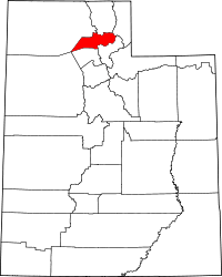 | |
| Town | ||
| CDPs | ||
| Unincorporated communities | ||