Lincoln Estate-Elm Park Historic District
|
Lincoln Estate-Elm Park Historic District | |
|
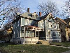
Corner of Sever and Cedar Streets | |
  | |
| Location | Properties along Cedar, Fruit, Oak, Sever, West, and William Sts., Worcester, Massachusetts |
|---|---|
| Coordinates | 42°16′2″N 71°48′40″W / 42.26722°N 71.81111°WCoordinates: 42°16′2″N 71°48′40″W / 42.26722°N 71.81111°W |
| Built | 1847 |
| Architect | Multiple |
| Architectural style | Second Empire, Queen Anne, Shingle Style |
| MPS | Worcester MRA |
| NRHP Reference # | 80000570[1] |
| Added to NRHP | March 05, 1980 |
The Lincoln Estate-Elm Park Historic District is an expansive residential area in northwestern Worcester, Massachusetts. It is centered on Cedar and William Streets, and includes properties on adjacent streets. The area was developed beginning in the late 1830s by former Governor of Massachusetts Levi Lincoln, Jr., a Worcester native who had inherited land in the area. The district was divided and developed by Lincoln until his death, and then by his heirs, and became a popular location for homes of Worcester's wealthy and elite, many of which were designed by architects.[2]
The district was listed on the National Register of Historic Places in 1980.[1]
See also
- National Register of Historic Places listings in northwestern Worcester, Massachusetts
- National Register of Historic Places listings in Worcester County, Massachusetts
References
- 1 2 National Park Service (2008-04-15). "National Register Information System". National Register of Historic Places. National Park Service.
- ↑ "NRHP nomination for Lincoln Estate-Elm Park Historic District". Commonwealth of Massachusetts. Retrieved 2014-02-18.
| Topics |  | ||||||||||||||||||||||||||||||
|---|---|---|---|---|---|---|---|---|---|---|---|---|---|---|---|---|---|---|---|---|---|---|---|---|---|---|---|---|---|---|---|
| Lists by county | |||||||||||||||||||||||||||||||
| Lists by city |
| ||||||||||||||||||||||||||||||
| Other lists | |||||||||||||||||||||||||||||||
| |||||||||||||||||||||||||||||||
This article is issued from Wikipedia - version of the 11/27/2016. The text is available under the Creative Commons Attribution/Share Alike but additional terms may apply for the media files.