Link River
| Link River | |
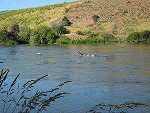 Link River, upstream of the Link River Dam | |
| Name origin: Waterway connecting two lakes[1] | |
| Country | United States |
|---|---|
| State | Oregon |
| County | Klamath |
| Source | Upper Klamath Lake |
| - elevation | 4,149 ft (1,265 m) [2] |
| - coordinates | 42°14′19″N 121°48′15″W / 42.23861°N 121.80417°W [3] |
| Mouth | Lake Ewauna |
| - location | Klamath Falls |
| - elevation | 4,091 ft (1,247 m) [3] |
| - coordinates | 42°13′08″N 121°47′18″W / 42.21889°N 121.78833°WCoordinates: 42°13′08″N 121°47′18″W / 42.21889°N 121.78833°W [3] |
| Length | 1.5 mi (2.4 km) [4] |
| Basin | 3,810 sq mi (9,868 km2) [5] |
| Discharge | for 0.4 miles (0.64 km) upstream of Main Street Bridge |
| - average | 1,276 cu ft/s (36 m3/s) [5] |
| - max | 9,400 cu ft/s (266 m3/s) |
| - min | 17 cu ft/s (0 m3/s) |
 Location of the mouth of the Link River in Oregon | |
| Wikimedia Commons: Link River | |
The Link River is a short river connecting Upper Klamath Lake to Lake Ewauna in the city of Klamath Falls in the U.S. state of Oregon.[1] Draining a basin of 3,810 square miles (9,900 km2),[5] the river begins at the southern end of Klamath Lake and flows a short distance to the Link River Dam and continues 1.5 miles (2.4 km) to the head of Lake Ewauna. The "falls" from which Klamath Falls derives its name, and which in reality are best described as rapids rather than falls, are visible a short distance below the dam, though the water flow is generally insufficient to provide water flow over the rocks. The Klamath River begins at the narrow southern end of Lake Ewauna and flows 253 miles (407 km) from there to the Pacific Ocean.[4]
Before settlers came to the Klamath Basin, the Link River was known to the local Klamaths as Yulalona, meaning "back and forth."[1] At times, strong winds blew the water upstream into Klamath Lake and partly drained the riverbed.[1]
After its founding in 1867, Klamath Falls was originally named Linkville.[1] The name was changed to Klamath Falls in 1892–93.[6]
See also
 Media related to Link River at Wikimedia Commons
- List of rivers of Oregon
References
- 1 2 3 4 5 McArthur, p. 580
- ↑ Source elevation derived from Google Earth search using GNIS source coordinates.
- 1 2 3 "Link River". Geographic Names Information System. United States Geological Survey. November 28, 1980. Retrieved April 20, 2011.
- 1 2 United States Geological Survey. "United States Geological Survey Topographic Map". TopoQuest. Retrieved April 4, 2011. The maps include river mile (RM) markers for the entire length of the Klamath and Link Rivers. The markers begin at the mouth of the Klamath on the Pacific Ocean, and the Link flows from between markers 255 and 254 to marker 253. The relevant map quadrangle is Klamath Falls.
- 1 2 3 "Water-Data Report 2010: 11507500 Link River at Klamath Falls, OR" (PDF). United States Geological Survey. Retrieved April 20, 2011.
- ↑ McArthur, p. 541
Works cited
- McArthur, Lewis A., and McArthur, Lewis L. (2003) [1928]. Oregon Geographic Names, 7th ed. Portland: Oregon Historical Society Press. ISBN 0-87595-277-1.