List of Copenhagen Metro stations
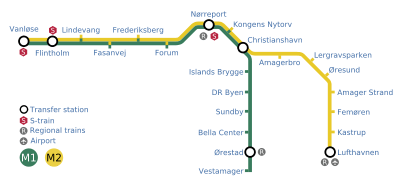

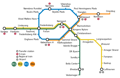
There are 22 stations in the Copenhagen Metro, a driverless rapid transit system serving Copenhagen, Frederiksberg and Tårnby in Denmark.[1] Nine of these metro stations are underground, twelve are elevated, and one is street-level.[2] Christianshavn Station offers transfer between the system's two metro lines (M1 and M2), which share track between Vanløse and Christianshavn stations. From Christianshavn, M1 branches south traveling to Vestamager Station, while M2 heads southeast to Lufthavnen Station, which serves Copenhagen Airport. Flintholm, Nørreport and Vanløse stations offer transfer to the S-train,[1] the city's other rapid transit system which the Copenhagen Metro was built to supplement.[3] Transfer from the Copenhagen Metro to regional trains is possible at Lufthavnen, Nørreport and Ørestad stations.[1] The City Circle Line, which is under construction and scheduled to open in 2019, is planned to have 17 stations, with transfer between the current and new lines at Christianshavn and Kongens Nytorv stations. The new lines will have a stop at Copenhagen Central Station (København H), the largest train station in Denmark.[4]
The Copenhagen Metro opened in 2002, with additional stations opened in 2003, and the M2 branch to the airport completed in 2007.[5] M1 and M2 are in total 21 kilometers (13 mi) long, of which 10 kilometers (6.2 mi) is in tunnels and 11 kilometers (6.8 mi) is elevated. Each line takes 23 minutes to travel from one end to the other.[6] The City Circle Line is intended to form a 15.5-kilometer (9.6 mi) loop around the city center, with a full circumference taking 25 minutes. The plan is for M3 to operate the full circle and for M4 to only operate the eastern half.[4] The system is owned by Metroselskabet, a company owned jointly by the municipalities of Copenhagen and Frederiksberg, and the government of Denmark. The metro and its 34 trains are operated by the private company Metro Service.[7]
Key
The following two lists name the stations. The first lists the stations that opened between 2002 and 2007, while the second lists those that are planned to open in 2018 with City Circle Line.[4] The first table states the stations name, which lines serve it, whether it is elevated or underground (the grade), travel time in minutes to Nørreport, the ticket zone and any transfer possibilities available at the station.[1][2] The second table lists the stations on the City Circle Line, which lines are scheduled serve it and available transfers. All M3 stations will be underground.[4][8]
| † | Terminal station |
|---|---|
| # | Transfer station |
Current stations
| Station | Line | Grade | Opened | Time | Zone | Transfer |
|---|---|---|---|---|---|---|
| Amager Strand | | Elevated | 2007 | 10 | 3 | — |
| Amagerbro | | Underground | 2002 | 5 | 1 | — |
| Bella Center | | Elevated | 2002 | 11 | 3 | — |
| Christianshavn# | | Underground | 2003 | 3 | 1 | — |
| DR Byen | | Elevated | 2002 | 7 | 1, 3 | — |
| Fasanvej | | Underground | 2003 | 5 | 2 | — |
| Femøren | | Elevated | 2007 | 12 | 3 | — |
| Flintholm | | Elevated | 2004 | 8 | 2 | S-train |
| Forum | | Underground | 2003 | 2 | 1 | — |
| Frederiksberg | | Underground | 2003 | 3 | 1, 2 | — |
| Islands Brygge | | Underground | 2002 | 5 | 1 | — |
| Kastrup | | Elevated | 2007 | 14 | 4 | — |
| Kongens Nytorv | | Underground | 2002 | 2 | 1 | — |
| Lergravsparken | | Underground | 2002 | 7 | 1 | — |
| Lindevang | | Elevated | 2003 | 7 | 2 | — |
| Lufthavnen† | | Elevated | 2007 | 15 | 4 | Regional trains, Copenhagen Airport |
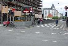
| Nørreport | | Underground | 2002 | 0 | 1 | Regional trains, S-train |
| Ørestad | | Elevated | 2002 | 12 | 3 | Regional trains |
| Øresund | | Elevated | 2007 | 9 | 3 | — |
| Sundby | | Elevated | 2002 | 9 | 3 | — |
| Vanløse† | | Street Level | 2003 | 9 | 2 | S-train |
| Vestamager† | | Elevated | 2002 | 14 | 3 | — |
Future stations
| Station | Line | Transfer |
|---|---|---|
| Aksel Møllers Have | | — |
| Gammel Strand | | — |
| Enghave Plads | | — |
| Marmorkirken | | — |
| Frederiksberg# | | — |
| København H† | | Regional trains, S-train, Copenhagen Central Station |
| Kongens Nytorv# | | — |
| Nordhavn | | S-train |
| Nuuks Plads | | — |
| Nørrebro | | S-train |
| Nørrebros Runddel | | — |
| Orientkaj† | | — |
| Østerport | | Regional trains, S-train |
| Frederiksberg Allé | | — |
| Poul Henningsens Plads | | — |
| Rådhuspladsen | | — |
| Skjolds Plads | | — |
| Trianglen | | — |
| Vibenshus Runddel | | — |
The M4 was previously planned to service Trianglen, Poul Henningsens Plads, Vibenshus Runddel and Nørrebro stations on a temporary basis. This plan has been abandoned, and the M4 is currently planned to serve the København H - Østerport - Orientkaj route. Both the City Circle Line and the two Nordhavn stations are planned to open in 2019.
References
- 1 2 3 4 "Welcome to the Metro!". Metroselskabet. 2008. Archived from the original (PDF) on 29 May 2009. Retrieved 20 December 2009.
- 1 2 Jensen, Tommy O. (2002). "Bag om metroen" (PDF). Jernbanen (in Danish) (5): 32–41.
- ↑ "S-tog køreplan 2009" (PDF) (in Danish). DSB. 2009. Retrieved 20 December 2009.
- 1 2 3 4 "Cityringen" (PDF) (in Danish). Metroselskabet. 2008. Retrieved 20 December 2009.
- ↑ "Copenhagen Metro – the history". Metroselskabet. Retrieved 20 December 2009.
- ↑ "About the Metro". Metroselskabet. Archived from the original on 2 August 2009. Retrieved 20 December 2009.
- ↑ "Metroens organisering" (in Danish). Metroselskabet. Retrieved 20 December 2009.
- ↑ "Navn på metrostation: Nuuks Plads" (in Danish). TV 2. 1 December 2009. Retrieved 20 December 2009.
External links
| Wikimedia Commons has media related to Copenhagen Metro. |
| Lines |  | |
|---|---|---|
| Stations | ||
| Train | ||