List of Indiana state historical markers in Bartholomew County
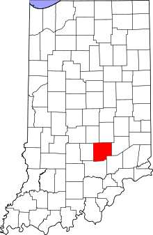
Location of Bartholomew County in Indiana
This is a list of the Indiana state historical markers in Bartholomew County.
This is intended to be a complete list of the official state historical markers placed in Bartholomew County, Indiana, United States by the Indiana Historical Bureau. The locations of the historical markers and their latitude and longitude coordinates are included below when available, along with their names, years of placement, and topics as recorded by the Historical Bureau. There are 9 historical markers located in Bartholomew County.[1]
Historical markers
| Marker title | Image | Year placed | Location | Topics |
|---|---|---|---|---|
| Lowell Mills[2] | 1988 | Junction of County Road 325W and Driftwood Road at a Driftwood River public access site, west of Columbus and Interstate 65 39°14′23″N 85°58′22″W / 39.23972°N 85.97278°W |
Business, Industry, and Labor, Historic District, Neighborhoods, and Towns | |
| Private Barton W. Mitchell[3] | 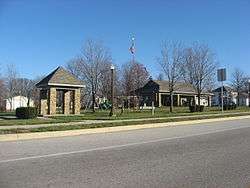 |
1992 | Southwestern corner of the town square at the junction of State Road 46 (E. Harrison Street) and N. Washington Street in Hartsville 39°16′4″N 85°41′56″W / 39.26778°N 85.69889°W |
Military |
| Hartsville College[4] | 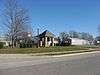 |
1995 | Southeastern corner of the town square at the junction of State Road 46 (E. Harrison Street) and N. Jackson Street in Hartsville 39°16′4″N 85°41′53″W / 39.26778°N 85.69806°W |
Education, Religion |
| Booker T. Washington School[5] | 1998 | Southeastern corner of the town square at the junction of State Road 46 (E. Harrison Street) and N. Jackson Street in Hartsville 39°16′4″N 85°41′53.1″W / 39.26778°N 85.698083°W |
African American, Education | |
| Second Baptist Church[6] | 1998 | 1328 9th Street at the Reed Street junction in Columbus 39°12′29″N 85°54′35″W / 39.20806°N 85.90972°W |
African American, Religion | |
| Madison and Indianapolis Railroad[7] | 1999 | 204 Railroad Road between 2nd and 3rd Streets on a grassy median in Elizabethtown 39°8′8″N 85°48′46″W / 39.13556°N 85.81278°W |
Transportation, Business, Industry, and Labor | |
| Bartholomew County Courthouse[8] | 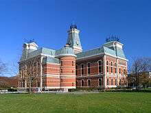 |
2000 | Southeastern corner of the courthouse at 234 Washington Street in Columbus 39°12′4″N 85°55′17″W / 39.20111°N 85.92139°W |
Government Institutions, Buildings and Architecture |
| Orinoco Furniture Company[9] | 2007 | 1720 17th Street in Columbus 39°12′57″N 85°54′24″W / 39.21583°N 85.90667°W |
Business, Industry, and Labor | |
| Atterbury Army Air Field[10] | 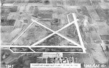 |
2007 | In front of the chapel at the junction of Middle Road and Grissom Avenue on Atterbury Army Air Field near Columbus 39°15′43″N 85°53′47″W / 39.26194°N 85.89639°W |
Military |
See also
- List of Indiana state historical markers
- National Register of Historic Places listings in Bartholomew County, Indiana
References
- ↑ "Indiana Historical Markers by County". State of Indiana. Retrieved 2012-03-15.
- ↑ Lowell Mills, Indiana Historical Bureau, n.d. Accessed 2012-03-14.
- ↑ Private Barton W. Mitchell, Indiana Historical Bureau, n.d. Accessed 2012-03-14.
- ↑ Hartsville College, Indiana Historical Bureau, n.d. Accessed 2012-03-14.
- ↑ Booker T. Washington School, Indiana Historical Bureau, n.d. Accessed 2012-03-14.
- ↑ Second Baptist Church, Indiana Historical Bureau, n.d. Accessed 2012-03-14.
- ↑ Madison and Indianapolis Railroad, Indiana Historical Bureau, n.d. Accessed 2012-03-14.
- ↑ Bartholomew County Courthouse, Indiana Historical Bureau, n.d. Accessed 2012-03-14.
- ↑ Orinoco Furniture Company, Indiana Historical Bureau, n.d. Accessed 2012-03-14.
- ↑ Atterbury Army Air Field, Indiana Historical Bureau, n.d. Accessed 2012-03-14.
External links
Municipalities and communities of Bartholomew County, Indiana, United States | ||
|---|---|---|
| City | ||
| Towns | ||
| Townships | ||
| CDP | ||
| Other unincorporated communities |
| |
| Footnotes | ‡This populated place also has portions in an adjacent county or counties | |
This article is issued from Wikipedia - version of the 12/16/2012. The text is available under the Creative Commons Attribution/Share Alike but additional terms may apply for the media files.