List of Indiana state historical markers in Grant County
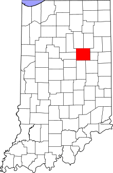
Location of Grant County in Indiana
This is a list of the Indiana state historical markers in Grant County.
This is intended to be a complete list of the official state historical markers placed in Grant County, Indiana, United States by the Indiana Historical Bureau. The locations of the historical markers and their latitude and longitude coordinates are included below when available, along with their names, years of placement, and topics as recorded by the Historical Bureau. There are 7 historical markers located in Grant County.[1]
Historical markers
| Marker title | Image | Year placed | Location | Topics |
|---|---|---|---|---|
| Battle of Mississinewa[2] |  |
1947 | Southeastern corner of the junction of State Road 15 and County Road 600N near Marion 40°38′24″N 85°42′34″W / 40.64000°N 85.70944°W |
Military, American Indian/Native American |
| New Purchase Boundary (Treaty of St. Mary's)[3] | _historical_marker.jpg) |
1966 | Northwestern corner of the Grant County Courthouse lawn at 401 S. Adams St. in Marion 40°33′31″N 85°39′26″W / 40.55861°N 85.65722°W |
Early Settlement and Exploration, American Indian/Native American, Government Institutions |
| Miami Indian Cemetery[4] | 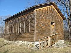 |
1972 | North of Marion on State Road 15, 1.1 miles west on County Road 600N 40°38′25″N 85°43′49″W / 40.64028°N 85.73028°W |
Cemetery, American Indian/Native American |
| [West Ward School][5] |  |
1988 | 210 W. North A Street in Gas City 40°29′20″N 85°37′2″W / 40.48889°N 85.61722°W |
Buildings and Architecture, Education |
| Former Narrow Gauge Railroad/Railroad Construction[6] | 1992 | Junction of E. 4th and McClure Streets in Marion 40°33′28″N 85°39′21.6″W / 40.55778°N 85.656000°W |
Transportation, Business, Industry, and Labor | |
| J.W. Patterson House[7] | 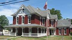 |
1995 | 203 E. Washington Street in Fairmount 40°24′57″N 85°38′57.6″W / 40.41583°N 85.649333°W |
Buildings and Architecture, Science, Medicine, and Inventions |
| The Village of Trask[8] |  |
1995 | Junction of State Road 26 and S. Wheeling Pike at Trask, 1.4 miles east of exit 55 from Interstate 69 40°25′22.6″N 85°31′23″W / 40.422944°N 85.52306°W |
Historic District, Neighborhoods, and Towns |
See also
- List of Indiana state historical markers
- National Register of Historic Places listings in Grant County, Indiana
References
- ↑ "Indiana Historical Markers by County". State of Indiana. Retrieved 2012-03-15.
- ↑ Battle of Mississinewa, Indiana Historical Bureau, n.d. Accessed 2012-03-14.
- ↑ New Purchase Boundary (Treaty of St. Mary's), Indiana Historical Bureau, n.d. Accessed 2012-03-14.
- ↑ Miami Indian Cemetery, Indiana Historical Bureau, n.d. Accessed 2012-03-14.
- ↑ [West Ward School], Indiana Historical Bureau, n.d. Accessed 2012-03-14.
- ↑ Former Narrow Gauge Railroad/Railroad Construction, Indiana Historical Bureau, n.d. Accessed 2012-03-14.
- ↑ J.W. Patterson House, Indiana Historical Bureau, n.d. Accessed 2012-03-14.
- ↑ The Village of Trask, Indiana Historical Bureau, n.d. Accessed 2012-03-14.
External links
Municipalities and communities of Grant County, Indiana, United States | ||
|---|---|---|
| Cities | ||
| Towns | ||
| Townships | ||
| CDPs | ||
| Unincorporated communities | ||
| Footnotes | ‡This populated place also has portions in an adjacent county or counties | |
This article is issued from Wikipedia - version of the 1/2/2015. The text is available under the Creative Commons Attribution/Share Alike but additional terms may apply for the media files.