Converse, Indiana
| Town of Converse, Indiana | |
|---|---|
| Town | |
|
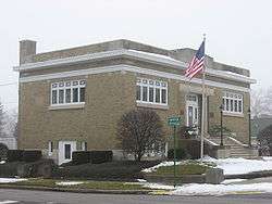
Library in Converse | |
 Location in the state of Indiana | |
| Coordinates: 40°34′47″N 85°52′8″W / 40.57972°N 85.86889°WCoordinates: 40°34′47″N 85°52′8″W / 40.57972°N 85.86889°W | |
| Country | United States |
| State | Indiana |
| Counties | Miami, Grant |
| Township | Jackson, Richland |
| Area[1] | |
| • Total | 0.90 sq mi (2.33 km2) |
| • Land | 0.90 sq mi (2.33 km2) |
| • Water | 0 sq mi (0 km2) |
| Elevation | 830 ft (253 m) |
| Population (2010)[2] | |
| • Total | 1,265 |
| • Estimate (2012[3]) | 1,249 |
| • Density | 1,405.6/sq mi (542.7/km2) |
| Time zone | EST (UTC-5) |
| • Summer (DST) | EST (UTC-5) |
| ZIP code | 46919 |
| Area code(s) | 765 |
| FIPS code | 18-14986[4] |
| GNIS feature ID | 0432907[5] |
| Website | http://www.townofconverse.com |
Converse is a town in Richland Township, Grant County and Jackson Township, Miami County, Indiana, United States. The population was 1,148 at the 2010 census.
History
Converse originally called Xenia, and under the latter name was laid out in 1849..[6] J. N. Converse platted an addition in 1867.[7]
The Converse Depot and Converse-Jackson Township Public Library are listed on the National Register of Historic Places.[8]
Geography
Converse is located at 40°34′47″N 85°52′8″W / 40.57972°N 85.86889°W (40.579654, -85.869022).[9]
According to the 2010 census, Converse has a total area of 0.9 square miles (2.33 km2), all land.[1]
Demographics
| Historical population | |||
|---|---|---|---|
| Census | Pop. | %± | |
| 1880 | 732 | — | |
| 1890 | 921 | 25.8% | |
| 1900 | 1,415 | 53.6% | |
| 1910 | 1,164 | −17.7% | |
| 1920 | 1,049 | −9.9% | |
| 1930 | 931 | −11.2% | |
| 1940 | 943 | 1.3% | |
| 1950 | 979 | 3.8% | |
| 1960 | 1,044 | 6.6% | |
| 1970 | 1,163 | 11.4% | |
| 1980 | 1,279 | 10.0% | |
| 1990 | 1,144 | −10.6% | |
| 2000 | 1,137 | −0.6% | |
| 2010 | 1,265 | 11.3% | |
| Est. 2015 | 1,231 | [10] | −2.7% |
2010 census
As of the census[2] of 2010, there were 1,265 people, 489 households, and 337 families residing in the town. The population density was 1,405.6 inhabitants per square mile (542.7/km2). There were 553 housing units at an average density of 614.4 per square mile (237.2/km2). The racial makeup of the town was 97.5% White, 0.1% African American, 0.2% Native American, 0.1% Asian, 0.1% Pacific Islander, 1.1% from other races, and 0.9% from two or more races. Hispanic or Latino of any race were 4.2% of the population.
There were 489 households of which 38.2% had children under the age of 18 living with them, 51.3% were married couples living together, 13.7% had a female householder with no husband present, 3.9% had a male householder with no wife present, and 31.1% were non-families. 27.2% of all households were made up of individuals and 12.7% had someone living alone who was 65 years of age or older. The average household size was 2.59 and the average family size was 3.12.
The median age in the town was 36.9 years. 29.7% of residents were under the age of 18; 6.4% were between the ages of 18 and 24; 27.3% were from 25 to 44; 23.8% were from 45 to 64; and 12.8% were 65 years of age or older. The gender makeup of the town was 48.1% male and 51.9% female.
2000 census
As of the census[4] of 2000, there were 1,137 people, 470 households, and 329 families residing in the town. The population density was 1,276.4 people per square mile (493.3/km²). There were 548 housing units at an average density of 615.2 per square mile (237.7/km²). The racial makeup of the town was 97.71% White, 0.18% African American, 0.35% Native American, 0.18% Asian, 0.79% from other races, and 0.79% from two or more races. Hispanic or Latino of any race were 2.99% of the population.
There were 470 households out of which 33.0% had children under the age of 18 living with them, 56.0% were married couples living together, 11.1% had a female householder with no husband present, and 29.8% were non-families. 27.0% of all households were made up of individuals and 13.8% had someone living alone who was 65 years of age or older. The average household size was 2.42 and the average family size was 2.91.
In the town the population was spread out with 26.0% under the age of 18, 6.8% from 18 to 24, 29.9% from 25 to 44, 22.6% from 45 to 64, and 14.7% who were 65 years of age or older. The median age was 37 years. For every 100 females there were 97.4 males. For every 100 females age 18 and over, there were 90.7 males.
The median income for a household in the town was $33,333, and the median income for a family was $42,813. Males had a median income of $35,938 versus $25,441 for females. The per capita income for the town was $16,317. About 12.6% of families and 15.7% of the population were below the poverty line, including 25.6% of those under age 18 and 6.8% of those age 65 or over.
Athletics
Converse is home to the Oak Hill United School Corporation, which oversees the Oak Hill High School Golden Eagles. The high school offers nine varsity sports for both boys and girls. The Golden Eagles have strong reputations throughout their history in many sports, including football, boys and girls cross country, boys basketball, wrestling, and boys and girls swimming. Before consolidating into the Oak Hill Community, Converse was home to its own high school, nicknamed the Bordermen, who were known for their good basketball teams and unique dress code for road games.
Notable persons
- Monte Towe, Denver Nuggets basketball player
References
- 1 2 "G001 - Geographic Identifiers - 2010 Census Summary File 1". United States Census Bureau. Retrieved 2015-07-16.
- 1 2 "American FactFinder". United States Census Bureau. Retrieved 2012-12-11.
- ↑ "Population Estimates". United States Census Bureau. Archived from the original on 2013-06-17. Retrieved 2013-06-25.
- 1 2 "American FactFinder". United States Census Bureau. Archived from the original on 2013-09-11. Retrieved 2008-01-31.
- ↑ "US Board on Geographic Names". United States Geological Survey. 2007-10-25. Retrieved 2008-01-31.
- ↑ Bodurtha , Arthur Lawrence (1914). History of Miami County, Indiana: A Narrative Account of Its Historical Progress, Its People and Its Principal Interests. Lewis Pub. p. 186.
- ↑ History of Miami County, Indiana: From the Earliest Time to the Present. Brant & Fuller. 1887. p. 626.
- ↑ National Park Service (2010-07-09). "National Register Information System". National Register of Historic Places. National Park Service.
- ↑ "US Gazetteer files: 2010, 2000, and 1990". United States Census Bureau. 2011-02-12. Retrieved 2011-04-23.
- ↑ "Annual Estimates of the Resident Population for Incorporated Places: April 1, 2010 to July 1, 2015". Retrieved July 2, 2016.
- ↑ "Census of Population and Housing". Census.gov. Archived from the original on May 11, 2015. Retrieved June 4, 2015.
External links
Municipalities and communities of Grant County, Indiana, United States | ||
|---|---|---|
| Cities | ||
| Towns | ||
| Townships | ||
| CDPs | ||
| Unincorporated communities | ||
| Footnotes | ‡This populated place also has portions in an adjacent county or counties | |
Municipalities and communities of Miami County, Indiana, United States | ||
|---|---|---|
| City | ||
| Towns | ||
| Townships | ||
| CDP | ||
| Other unincorporated communities | ||
| Footnotes | ‡This populated place also has portions in an adjacent county or counties | |