List of Arizona wildfires
This list is incomplete; you can help by expanding it.
| Arizona Wildfires | |
|---|---|
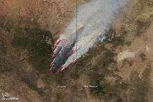
|
Photograph of the Wallow Fire from space. (June 8, 2011) | |
| Statistics |
This is a list of known wildfires in Arizona.
Statistics
| Wildland | Prescribed | |||
|---|---|---|---|---|
| Year | Fires | Acres | Fires | Acres |
| 2002[1] | 3,041 | 700,101 | 1,201 | 95,576 |
| 2003[2] | 2,876 | 192,538 | 450 | 111,460 |
| 2004[3] | 2,602 | 219,900 | 657 | 66,199 |
| 2005[4] | 4,027 | 975,456 | 452 | 111,452 |
| 2006[5] | 3,274 | 177,427 | 1,576 | 75,325 |
| 2007[6] | 2,240 | 101,381 | 363 | 98,593 |
| 2008[7] | 1,850 | 85,496 | 413 | 132,951 |
| 2009[8] | 2,371 | 263,358 | 2,097 | 147,531 |
| 2010[9] | 1,517 | 74,445 | 203 | 67,799 |
| 2011[10] | 1,969 | 1,036,935 | 160 | 55,069 |
| 2012[11] | 1,684 | 216,090 | 243 | 80,959 |
| 2013[12] | 1,449 | 100,836 | 90 | 32,605 |
Notable fires
| Year | Fire Name | Description | Cause | Vegetation[13] | County(ies) | Size | Structures Lost | Deaths | Injuries |
|---|---|---|---|---|---|---|---|---|---|
| 1977 | Radio Fire | Fire scorched the peak of Mount Elden in Flagstaff, Arizona. | Human | Ponderosa Pine / Mixed conifer / Grassland | Coconino | 4,600 ac
7.2 sq.mi. 1,862 ha |
0 | 0 | 0 |
| 1990 | Dude Fire[14] | Large fire on the Mogollon Rim that burned for 10 days. On June 25th, six firefighters were killed in a burn over. Including the first female wildland firefighter killed in Arizona. It was Arizona's worst forest fire in history at the time. | Lightning | Ponderosa Pine / Pine-Oak Woodland | Coconino | 28,000 ac
44 sq.mi. 11,331 ha |
63 | 6 | 0 |
| 1995 | Rio Fire[15][16] | Fast moving brush fire blackened 36 square miles of desert landscape, including a large part of McDowell Mountain Regional Park and sections of the McDowell Sonoran Preserve. | Lightning | Desert | Maricopa | 23,000 ac
36 sq.mi. 9,308 ha |
0 | 0 | 0 |
| 1996 | Lone Fir[17] | Largest fire in the history of the Tonto National Forest burns in the Four Peaks Wilderness. The state's largest fire in 25 years. | Human | Desert | Maricopa | 61,300 ac
96 sq.mi. 24,800 ha |
0 | 0 | 0 |
| 1996 May | Horseshoe Fire | Fire originated on Horseshoe Hill and spread NE. | Human | Ponderosa Pine / Grassland | Coconino | 8,100 ac
13.7 sq.mi. 3,280 ha |
0 | 0 | 0 |
| 1996 June | Hochderffer Fire | Fire originated on Hochderffer Hills and spread NE. | Lightning | Ponderosa Pine / Mixed conifer / Grassland | Coconino | 16,680 ac
25 sq.mi. 6,520 ha |
0 | 0 | 0 |
| 2000 May | Pumpkin Fire | Burned large portion of 10,423' (3177m) elevation Kendrick Peak. | Lightning | Ponderosa Pine / Mixed conifer | Coconino | 14,760 ac
23 sq.mi. 5,970 ha |
0 | 0 | 0 |
| 2002 | Rodeo–Chediski Fire | The Rodeo fire was intentionally started by a seasonal firefighter looking for employment, the Chediski fire was started by a stranded driver trying to attract a news helicopter. Largest fire in Arizona history at the time. | Human | Ponderosa / Pine-Oak / Juniper-Pinyon | Coconino / Gila / Navajo | 468,638 ac
732 sq.mi. 189,651 ha |
426 | 0 | 0 |
| 2003 | Aspen Fire | Fire on Mount Lemmon in the Santa Catalina Mountains burns through the town of Summerhaven, Arizona destroying 325 of 340 structures. | Human | Aspen / Pine-Oak / Conifer | Pima / Pinal | 84,750 ac
132 sq.mi. 34,297 ha |
325+ | 0 | 0 |
| 2004 | Willow Fire[18] | Large fire southwest of Payson, Arizona in the Mazatzal Wilderness. | Lightning | Desert Shrub / Chaparral | Gila | 119,500 ac
187 sq.mi. 48,360 ha |
0 | 0 | 0 |
| 2005 | Cave Creek Complex Fire | Two lightning caused fires merge to create the third largest wildfire in Arizona history. Fire destroyed the historic Cave Creek Mistress Mine, and likely lead to the death of the largest recorded saguaro cactus. | Lightning | Desert Grass / Chaparral / Mixed Conifer | Maricopa / Yavapai | 243,950 ac
381 sq.mi. 98,723 ha |
11+ | 0 | 0 |
| 2005 | Florida Fire | Lightning caused fire spread throughout the Santa Rita Mountains, destroyed the upper Florida Canyon watershed with its old-growth douglas fir forest. | Lightning | Oak Woodland, Mixed Conifer | Santa Cruz | 23,183 ac
36 sq.mi. 9,382 ha |
0 | 0 | 0 |
| 2006 | Brins Mesa Fire | On June 18, 2006, a wildfire, reportedly started by campers, began about one mile north of Sedona. The Brins Fire covered 4,317 acres on Brins Mesa, Wilson Mountain and in Oak Creek Canyon | Human | Ponderosa / Pine-Oak / Juniper-Pinyon | Yavapai /Coconino | 4317 ac | 0 | 0 | 0 |
| 2010 June | Schultz Fire | Burned large portion of 10,085' (3074m) elevation Schultz Peak and southeastern slopes of San Francisco Mountain. Extensive debris flows and flooding ensued into downslope residential areas beginning July 2010, resulting in one fatality. | Human | Ponderosa Pine / Mixed conifer | Coconino | 15,075 ac
23.5 sq.mi. 6,100 ha |
0 | 0 | 0 |
| 2011 | Horseshoe 2 Fire | Fifth largest fire in Arizona History burned the southeast flank of the Chiricahua Mountains in the Coronado National Forest. | Human | Desert Grassland, Scrub Oak, Pine | Cochise | 222,954 ac
348 sq.mi. 90,226 ha |
23 | 0 | 0 |
| 2011 | Monument Fire[19] | Human caused fire burns through the Miller Wilderness in the Huachuca Mountains and into Sierra Vista, Arizona. | Human | Conifer-Oak / Pinyon-Juniper | Cochise | 30,526 ac
48 sq.mi. 12,353 ha |
64 | 0 | 0 |
| 2011 | Wallow Fire | Largest fire in Arizona history burned 841 square miles of vegetation in the Apache National Forest near Alpine, Arizona. | Human | Ponderosa Pine / Gamble Oak / Sagebrush Shrubland | Apache / Graham / Greenlee / Navajo | 538,049 ac
841 sq.mi. 217,741 ha |
72 | 0 | 16 |
| 2012 | Gladiator Fire[20] | Residential fire sparks large fire in the Prescott National Forest near Crown King, Arizona. | Human | Pine-Oak / Ponderosa Pine | Yavapai | 16,240 ac
25 sq.mi. 6,572 ha |
6 | 0 | 8 |
| 2013 | Yarnell Hill Fire[21][22] | June 28 lightning started fire that grew rapidly due to high temperatures, low humidity and wind; near the town of Yarnell, about 85 miles NW of Phoenix; 19 firefighters killed; forced the closure of parts of state Route 89. | Lightning | Desert Grass, Pinyon-Juniper Woodlands | Yavapai | 8,500 ac
13 sq.mi. 3,440 ha[23] |
129 | 19 | 22 |
| 2014 | Slide Fire[24] | On May 20, 2014, around 4pm, a wildfire was reported just north of Slide Rock State Park. The fire was 100 percent contained on June 4, 2014, with 21,227 acres burned. Total personnel included over 1,230 firefighters, 50 crews, 29 engines and 9 helicopters | Human | Ponderosa / Pine-Oak / Juniper-Pinyon | Coconino | 21,227 ac | 0 | 0 | 0 |
| 2016 | Baker Canyon Fire | Unknown | Brush | Cochise | 7,980 ac | 0 | 0 | 0 | |
| 2016 | Topock Fire | Human | Brush | Mohave | 2,200 ac | 0 | 0 | 0 | |

(May 15, 2011) Photograph of the Horseshoe 2 Fire from the International Space Station. (Original Photo)
Lesser known fires
| Year | Fire Name | Description | Cause | Vegetation[13] | County(ies) | Size (acres) | Structures Lost | Deaths | Injuries |
|---|---|---|---|---|---|---|---|---|---|
| 1990 | Big Bug Fire | Small fire started by a loggers burning vehicle. | Human | N/A | Yavapai | 100 | 0 | 0 | 0 |
| 1990 | Bray Fire | Small fire on the Mogollon Rim near Bray Creek Ranch. | N/A | N/A | Coconino | N/A | N/A | N/A | N/A |
| 1990 | Doce Fire[25] | Fire of unknown origins burns a square mile of chaparral in the Granite Mountain Wilderness northwest of Prescott, Arizona. | N/A | Juniper Pinyon Woodland | Yavapai | 850 | 0 | 0 | 0 |
| 1990 | Encinosa Fire[26] | Small fire along U.S. Route 89 near Oak Creek Canyon. | N/A | Forest | Coconino | N/A | N/A | N/A | N/A |
| 1991 | Geronimo Fire[27] | Small fire caused by a Canadian hiker's unattended campfire 25 miles southwest of Flagstaff, Arizona in the Sycamore Canyon Wilderness. | Human | High Desert / River | Coconino | 85+ | 0 | 0 | 0 |
| 1991 | N/A | Fire about two miles east of Sunset Crater. | N/A | Forest | Coconino | 450 | 0 | 0 | 0 |
| 1992 | Troon Fire | Dry conditions helped fuel a brush fire near Troon Country Club. | N/A | Desert | Maricopa | 3,000 | 0 | 0 | 0 |
| 1994 | Warm Springs Fire[28] | N/A | N/A | Desert | Mohave | 7,000+ | N/A | N/A | N/A |
| 1994 | Black Mesa Fire | N/A | N/A | Desert | Yuma | 500+ | N/A | N/A | N/A |
| 1994 | Goodwin Mesa Fire | N/A | N/A | Desert / Juniper Pinyon | Yavapai | 150+ | N/A | N/A | N/A |
| 1995 | Dynamite Fire | Brush fire along the Verde River north of Rio Verde, Arizona. | N/A | Desert / River | Maricopa | 900 | 0 | 0 | 0 |
| 1995 | Geronimo Fire[29] | Brush fire in the Superstition Wilderness southeast of Apache Junction. | Human | Desert | Pinal | 2,200 | 0 | 0 | 0 |
| 1996 | Allentown Fire[30] | N/A | Lightning | Juniper Pinyon Woodland | Apache | 4,500 | 0 | 0 | 0 |
| 1996 | Clark Peak Fire[31] | Fire on Mount Graham burns territory of the endangered Mount Graham Red Squirrel and threatened the Mount Graham International Observatory. | Human | Fir Pine | Graham | 6,300 | 0 | 0 | 0 |
| 1996 | Hochderffer Fire[32] | Burned for two weeks and became the largest fire in the history of the Coconino National Forest. | Lightning | Ponderosa Pine | Coconino | 16,400 | 0 | 0 | 0 |
| 1996 | Witch Well Fire[33] | Fire 25 miles north of St. Johns, Arizona. | Lightning | Desert Scrub | Apache | 680 | 0 | 0 | 0 |
| 1999 | Harcuvar Fire[34] | Lightning caused fire near Welden, Arizona in the Harcuvar Wilderness Area. | Lightning | Desert | La Paz | 15,980 | 0 | 0 | 0 |
| 1999 | N/A | Lightning caused fire in the Arizona Strip country, 40 miles southwest of St. George, Utah. | Lightning | Desert / Juniper Pinyon | Mohave | 11,000+ | 0 | 0 | 0 |
| 1999 | N/A | Lightning caused fire west of Prescott. | Lightning | Grassland / Juniper Pinyon | Yavapai | 1,000 | 0 | 0 | 0 |
| 1999 | Rainbow Fire[35] | Fire north of Whiteriver, Arizona in the Fort Apache Indian Reservation. | Human | Ponderosa Pine | Navajo | 4,500 | 17+ | 0 | 0 |
| 2000 | Pumpkin Fire[36] | Lightning caused fire burned for 17 days on Kendrick Peak. | Lightning | Ponderosa Pine | Coconino | 14,760 | 1 | 0 | 0 |
| 2005 | Barfoot Fire[37] | Small fire near Pine Canyon Camp in the Chiricahua Mountains. | Lightning | Madrean Conifer-Oak / Aspen | Cochise | 1,600 | 0 | 0 | 0 |
| 2005 | Edge Complex Fire[38] | Lightning caused fire south of Mount Ord between Sunflower, Arizona and Punkin Center, Arizona. | Lightning | Chaparral / Pine-Oak | Gila | 71,635 | 0 | 0 | 0 |
| 2005 | Twin Mills Fire[39] | Lightning sparked fire burns 3 miles northwest of Golden Valley, Arizona. | Lightning | Grassland / Forb / Pinyon-Juniper | Mohave | 12,000 | 0 | 0 | 0 |
| 2009 | Hyde Fire[40] | Slow moving fire in the Prescott National Forest. | Lightning | Mixed Conifer / Chaparral | Yavapai | 245 | 0 | 0 | 0 |
| 2009 | Pioneer Fire[41] | Near the Pioneer Pass Campground 8 miles south of Globe, Arizona. | Lightning | Pine-Oak / Ponderosa Pine / Chaparral | Gila | 1,375 acres | 0 | 0 | 0 |
| 2009 | Point Fire | Three miles northeast of Pine, Arizona. | Lightning | Ponderosa Pine | Coconino / Gila | 650+ | 0 | 0 | 0 |
| 2009 | Reno Fire[42] | Lightning caused fire on Gobbler Point 5 miles southwest of Alpine, Arizona. | Lightning | Ponderosa Pine | Apache | 6,322 | 0 | 0 | 0 |
| 2009 | Ruby Complex Fire[43] | Two lightning sparked fires, the Game Reserve Fire, and the Ruby Fire merge in the Kaibab National Forest. | Lightning | Ponderosa / Pinyon-Juniper | Coconino | 4,644+ | 0 | 0 | 0 |
| 2009 | Water Wheel Fire[44] | Fire started by campers at the Water Wheel Campground threatens the community of Beaver Valley. | Human | Pine-Oak Forest / Chaparral | Gila | 800 | 0 | 0 | 0 |
| 2010 | Big Bug Fire[45] | Small fire believed to be started by a dragging chain burned private property along State Route 69 near Mayer, Arizona. | Human | N/A | Yavapai | 65 | 0 | 0 | 0 |
| 2010 | 89 Mesa Fire[46] | May have been started by Arizona Game and Fish employees welding in the area. | Human | Ponderosa Pine | Coconino | 523 | 0 | 0 | 0 |
| 2010 | Eagle Rock Fire[47] | Lightning caused fire about 15 miles northeast of Williams, Arizona. | Lightning | Ponderosa Pine / Mixed Conifer | Coconino | 3,420 | 0 | 0 | 0 |
| 2010 | Hardy Fire[45] | Transient suspected of starting the fire. | Human | Ponderosa Pine | Coconino | 282 | 0 | 0 | 0 |
| 2010 | Schultz Fire | Started by an abandoned campfire. | Human | Aspen, Spruce-fir Pine, Mixed Conifer | Coconino | 15,000 | 0 | 0 | 2 |
| 2011 | Arlene Fire[48] | Fire 3 miles east of Lochiel, Arizona near Parker Canyon Lake. | N/A | Desert Grassland, Scrub Oak | Cochise | 10,610 | 0 | 0 | 0 |
| 2011 | Beale Fire[49] | Lightning fire southwest of Kendrick Mountain. | Lightning | Ponderosa Pine / Aspen / Mixed Conifer | Coconino | 5,100+ | 0 | 0 | 0 |
| 2011 | Diamond Fire[50] | Lightning ignited fire east of Whiteriver, Arizona, north of the Black River near 10 of Diamonds Ranch. | Lightning | Ponderosa Pine / Mixed Conifer / Pinyon-Juniper | Apache | 65 | 0 | 1 | 0 |
| 2011 | Empire Fire[45] | Brush fire 8 miles north of Sonoita, Arizona. | Human | Desert Grassland | Pima / Santa Cruz | 2,009 | 0 | 0 | 1 |
| 2011 | Empire II Fire[51] | Fast moving grass fire north of Sonoita, Arizona in the Las Cienegas National Conservation Area. | Human | Desert Grassland | Pima / Santa Cruz | 600 | 0 | 0 | 0 |
| 2011 | Greaterville Fire[52] | Fire started by a welder in the Coronodo Nation Forest, 10 miles southeast of Green Valley, Arizona. | Human | Madrean Encinal / Mixed Conifer / Pine-Oak | Pima | 1,800 | 0 | 0 | 0 |
| 2011 | Murphy Complex Fire[53] | Three lightning sparked fires, the Bull Fire, Pena Fire, and Murphy Fire merge in the Tumacacori Mountains, 3 miles east of Arivaca, Arizona. | Lightning | Madrean Encinal | Santa Cruz | 68,078 | 0 | 0 | 2 |
| 2011 | Point Fire[54] | Lightning ignited fire on the north rim of the Grand Canyon. | Lightning | Ponderosa / Mixed Conifer | Coconino | 4,195 | 0 | 0 | 0 |
| 2011 | Tanner Fire[55] | Lightning caused fire started on Armer Mountain in the Sierra Ancha Mountains south of Young, Arizona. | Lightning | Ponderosa Pine / Pine-Oak | Gila | 5,500 | 0 | 0 | 0 |
| 2012 | Apache Pass Fire[56] | Small fire north of Fort Bowie. | Human | Desert Grassland | Cochise | 1,686 | 0 | 0 | 0 |
| 2012 | 257 Fire[57] | Small fire 4 miles southeast of Superior, Arizona. | N/A | Desert Scrub | Pinal | 2,860 | 0 | 0 | 0 |
| 2012 | Bull Flat Fire[58] | Area recovering from the 2002 Rodeo-Chediski fire. | Lightning | Grass, Brush, Deadwood | Gila | 2,147 | 0 | 0 | 0 |
| 2012 | Cooks Complex Fire[59] | Three separate lightning ignited fires merge into one, 5 miles east of Black Canyon City, Arizona. | Lightning | Desert Scrub | Yavapai | 7,299 | 0 | 0 | 0 |
| 2012 | Fox Fire[60] | Six miles south of Superior, Arizona. | Lightning | Desert Scrub | Pinal | 7,500 | 0 | 0 | 0 |
| 2012 | Grapevine Fire[61] | Twenty miles southwest of Safford, Arizona. | Lightning | Desert Grass, Shrubs | Graham | 19,100 | 0 | 0 | 0 |
| 2012 | Hobble Complex Fire[62] | Four lightning sparked fires merge 35 miles south of St. George, Utah. | Lightning | Desert Grass / Juniper Pinyon | Mohave | 35,000 | 0 | 0 | 0 |
| 2012 | Montezuma Fire[63] | Fire on the Tohono O'odham Indian Resorvation in the Baboquivari Peak Wilderness. | N/A | Madrean Pinyon-Juniper | Pima | 1,700 | 1 | 2 | 0 |
| 2012 | Plateau Fire[64] | N/A | Lightning | Desert Grass / Juniper Pinyon | Mohave | 3,175 | 0 | 0 | 0 |
| 2012 | Poco Fire[65] | Six miles northeast of Young, Arizona, within miles of the recent Bull Flat Fire. | Human | Ponderosa Pine | Gila | 11,950 | 0 | 0 | 2 |
| 2012 | School Canyon Fire[66] | Fire in the San Rafael Valley that began in Mexico and spread across the border into Arizona. | Human | Grassland, Desert Scrub, Madrean Encinal | Cochise, Santa Cruz | 7,049 | 0 | 0 | 0 |
| 2012 | Sunflower Fire[67] | Started by an incendiary shotgun round along Sycamore Creek, near Sunflower, 30 miles north of Mesa.[68][69] | Human | Chaparral, Grass, Pinyon, Cypress | Maricopa | 17,446 | 0 | 0 | 0 |
| 2012 | West Side Complex Fire[70] | Eight lightning started fires on the west side of the Kaibab Plateau in the Coconino National Forest north of the Kanab Creek Wilderness. | Lightning | Desert Grass, Pinyon-Juniper Woodlands | Mohave | 2,871 | 0 | 0 | 0 |
- 2016; Tenderfoot Fire; Yarnell, Arizona[71][72]
References
- ↑ "2002 National Year-to-Date Report on Fires and Acres Burned by State". National Interagency Fire Center. Retrieved 26 August 2013.
- ↑ "2003 National Year-to-Date Report on Fires and Acres Burned by State". National Interagency Fire Center. Retrieved 26 August 2013.
- ↑ "2004 National Year-to-Date Report on Fires and Acres Burned by State". National Interagency Fire Center. Retrieved 26 August 2013.
- ↑ "2005 National Year-to-Date Report on Fires and Acres Burned by State". National Interagency Fire Center. Retrieved 26 August 2013.
- ↑ "2006 National Year-to-Date Report on Fires and Acres Burned by State". National Interagency Fire Center. Retrieved 26 August 2013.
- ↑ "2007 National Year-to-Date Report on Fires and Acres Burned by State". National Interagency Fire Center. Retrieved 26 August 2013.
- ↑ "2008 National Year-to-Date Report on Fires and Acres Burned by State". National Interagency Fire Center. Retrieved 26 August 2013.
- ↑ "2009 National Year-to-Date Report on Fires and Acres Burned by State". National Interagency Fire Center. Retrieved 26 August 2013.
- ↑ "2010 National Year-to-Date Report on Fires and Acres Burned by State". National Interagency Fire Center. Retrieved 26 August 2013.
- ↑ "2011 National Year-to-Date Report on Fires and Acres Burned by State". National Interagency Fire Center. Retrieved 26 August 2013.
- ↑ "2012 National Year-to-Date Report on Fires and Acres Burned by State". National Interagency Fire Center. Retrieved 26 August 2013.
- ↑ "2013 National Year-to-Date Report on Fires and Acres Burned by State". National Interagency Fire Center. Retrieved 26 August 2013.
- 1 2 "HabiMap Arizona". The Arizona Experience / Arizona Game & Fish. Retrieved 26 August 2013.
- ↑ "Staff Ride to the Dude Fire". Wildland Fire Leadership Development Program - Wildland Fire Staff Ride Library. Retrieved 26 August 2013.
- ↑ "Flame & Flood". NASA - Earth Observatory. Retrieved 26 August 2013.
- ↑ "Rio Fire contained; Tonto's doubles". Tucson Citizen. Retrieved 26 August 2013.
- ↑ "The Lone Fire". United States Department of Agriculture - Forest Service - Tonto National Forest. Retrieved 26 August 2013.
- ↑
- ↑ "Archived copy". Archived from the original on April 16, 2012. Retrieved August 7, 2012.
- ↑ "Archived copy". Archived from the original on August 15, 2012. Retrieved August 7, 2012.
- ↑ "19 Firefighters Dead in Ariz. Blaze, Official Says". ABC News. Retrieved 1 July 2013.
- ↑ "InciWeb the Incident Information System: Yarnell Hill Fir". Nwcg.gov. Retrieved 9 June 2016.
- ↑ "Yarnell Hill wildfire now 80 percent contained". KTAR TV. Retrieved 5 July 2013.
- ↑ Benson, Phil (4 June 2014). "Slide Fire fully contained; cost reaches $10.1 million". KPHO. Retrieved 25 March 2016.
- ↑ Alexieff, Michael "The story of the Doce fire" The Prescott Courier [Prescott, Arizona] October 14, 1990
- ↑
- ↑ "Campfire blamed for 'Geronimo' fire" Kingman Daily Miner [Kingman, Arizona] May 26, 1991, page 1
- ↑ "BLM calls in more firefighters as new wildfires hit state - Tucson Citizen Morgue, Part 2 (1993-2009)". Tucsoncitizen.com. Retrieved 9 June 2016.
- ↑
- ↑ "Range fire burns 4,500 acres" The Sunday Courier - Jun 9, 1996
- ↑
- ↑ "Biological Opinion Summary : Hochderffer Fire" (PDF). Retrieved 9 June 2016.
- ↑ "Firefighters battle blazes across state - Tucson Citizen Morgue, Part 2 (1993-2009)". Tucsoncitizen.com. Retrieved 9 June 2016.
- ↑ "Fire in the desert" Arizona Republic [Phoneix, Arizona] Jun 10, 1999
- ↑ "Archived copy". Archived from the original on May 31, 2010. Retrieved August 7, 2012.
- ↑
- ↑ "Barfoot Fire up to 1,600 acres in Chiricahuas". Azstarnet.com. Retrieved 9 June 2016.
- ↑ "Edge Complex Fire Map" (PDF). Retrieved 9 June 2016.
- ↑ "ICS-209 Form". Fam.nwcg.gov. Retrieved 9 June 2016.
- ↑ "Prescott National Forest - News & Events". Fs.usda.gov. Retrieved 9 June 2016.
- ↑ "Archived copy". Archived from the original on June 10, 2009. Retrieved August 7, 2012.
- ↑
- ↑ "Archived copy". Archived from the original on January 9, 2010. Retrieved August 7, 2012.
- ↑ "Archived copy". Archived from the original on September 4, 2009. Retrieved August 7, 2012.
- 1 2 3 "Archived copy". Archived from the original on February 12, 2016. Retrieved June 9, 2016.
- ↑ "Coconino National Forest - News & Events". Fs.usda.gov. Retrieved 9 June 2016.
- ↑ "Archived copy". Retrieved August 7, 2012.
- ↑ "Archived copy". Archived from the original on August 17, 2011. Retrieved August 7, 2012.
- ↑ "Arizona wildfires: Beale Fire tops 5,000 acres". Azcentral.com. Retrieved 9 June 2016.
- ↑ "Archived copy" (PDF). Archived from the original (PDF) on June 18, 2013. Retrieved August 7, 2012.
- ↑
- ↑
- ↑ "Archived copy". Archived from the original on October 15, 2011. Retrieved August 7, 2012.
- ↑ "Archived copy". Archived from the original on December 30, 2011. Retrieved August 7, 2012.
- ↑ "Archived copy". Archived from the original on January 2, 2012. Retrieved August 7, 2012.
- ↑ "Archived copy". Retrieved August 7, 2012.
- ↑ "Archived copy". Archived from the original on June 18, 2012. Retrieved August 7, 2012.
- ↑ "Archived copy". Archived from the original on May 21, 2012. Retrieved August 7, 2012.
- ↑
- ↑ "Archived copy". Archived from the original on August 18, 2012. Retrieved August 7, 2012.
- ↑ "Archived copy". Retrieved August 7, 2012.
- ↑ "Archived copy". Archived from the original on August 18, 2012. Retrieved August 7, 2012.
- ↑ "Archived copy". Archived from the original on June 16, 2012. Retrieved August 7, 2012.
- ↑ "Archived copy". Archived from the original on July 19, 2012. Retrieved August 7, 2012.
- ↑ "Archived copy". Archived from the original on August 15, 2012. Retrieved August 7, 2012.
- ↑ "Archived copy". Archived from the original on July 31, 2012. Retrieved August 7, 2012.
- ↑ "Archived copy". Archived from the original on August 18, 2012. Retrieved August 7, 2012.
- ↑ Bill Schumm (10 July 2012). "New Ways To Start Wildfires". Firegeezer. Retrieved 1 January 2013.
- ↑ Carina Sonn (2 July 2012). "Mesa man charged for starting Sunflower wildfire with shotgun". Firegeezer. Retrieved 1 January 2013.
- ↑
- ↑ "New fire in Yarnell: Voluntary evacuations underway". Usatoday.com. Retrieved 9 June 2016.
- ↑ "Yarnell residents face new fire with horror, heartbreak". Azcentral.com. Retrieved 9 June 2016.
External links
| Wikimedia Commons has media related to Wildfires_in_Arizona. |
- National Interagency Fire Center
- InciWeb - Arizona Incidents
- Southwest Coordination Center
- Arizona Interagency Wildfire Prevention
- US Forest Service
- Fire Restrictions - Arizona
- Public Lands Information Center - Arizona Fire News
- Coconino NF fire history web map
This article is issued from Wikipedia - version of the 9/21/2016. The text is available under the Creative Commons Attribution/Share Alike but additional terms may apply for the media files.