Lochiel, Arizona
| Lochiel, Arizona | |
|---|---|
| Ghost town | |
|
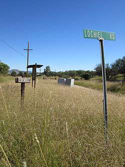
Road signs in Lochiel. Part of the town and the international border can be seen in the background. | |
 Lochiel, Arizona  Lochiel, Arizona Location within Santa Cruz County | |
| Coordinates: 31°20′06″N 110°37′29″W / 31.33500°N 110.62472°WCoordinates: 31°20′06″N 110°37′29″W / 31.33500°N 110.62472°W | |
| Country | United States |
| State | Arizona |
| County | Santa Cruz |
| Time zone | Mountain (MST) (UTC-7) |
Lochiel is a ghost town and former border crossing in southern Santa Cruz County, Arizona, approximately 25 miles east of Nogales. The townsite is located in the southwestern part of the San Rafael Valley on Washington Gulch about 1.5 miles west of the Santa Cruz River.[1] It was first settled in the late-1870s and mostly abandoned by 1986.[2][3] The town served the ranches of the San Rafael Valley and the Washington Camp and Duquesne mining towns of the Patagonia Mountains about five miles to the northwest up Washington Gulch.[1]
Name
The present-day Lochiel was originally known by local Mexican settlers as La Noria, which is Spanish for a wheel-drawn well, and later as Luttrell, before being renamed "Lochiel" by the rancher Colin Cameron in 1884.[3][4]
Lochiel is the main branch of Clan Cameron, some of the chiefs of which − such as Donald Cameron of Lochiel − figure prominently in Scottish history. "The Lands of Lochiel" were united into the Barony of Lochiel in the early sixteenth century. It was originally "bounded by [the lands of] Clanranald on the west, by the waters of Lochy and Lochiel on the south, and by [the lands of Clan] Mackintosh on the east and north." In 1633, an act of Scottish Parliament transferred certain Mackintosh lands to Lochiel, including Tor Castle.[5]
History
The Lochiel area was originally inhabited by a small community of Mexican ranchers before a smelting works was erected in the late 1870s to serve the nearby mines in the Patagonia Mountains, bringing in American settlers. By 1881, a town by the name of Luttrell had formed and was home to some 400 people, most of whom worked in the smelter or in the mines, as well as five stores, three saloons, a brewery, a butcher shop, a bakery, livery stables, and a boarding house operated by a one Dr. Luttrell, for whom the town was originally named.[3][4]
In 1884 the cattle baron Colin Cameron established the San Rafael Ranch about a mile north of Luttrell. That same year he managed to have the postmaster in town rename it "Lochiel", after his homeland back in Scotland. Several years after that, the international boundary between Sonora and Arizona was surveyed and it was found that half of the settlement was in Mexican territory. The town was then split in two. La Noria became the name of the Mexican part of town while the American side continued to be known as Lochiel.[3][4]
In the early 1910s, Pancho Villa and his men rustled cattle and horses in the area on more than one occasion. By this time, the famed businessman William Cornell Greene had acquired ownership of the San Rafael Ranch to use as his headquarters for his cattle ranching empire. The ranch remained in the ownership of Greene's family all the way up until 1998, when it was sold to The Nature Conservancy and Arizona State Parks for use as a nature preserve.[3][6][7]
A few people still live in Lochiel to this day. In addition to a collection of old houses, Lochiel is the site of an adobe one-room schoolhouse, a teacherage, an old adobe church, and an abandoned U.S. Customs station. Lochiel is also the site where Fray Marcos de Niza first entered what is now Arizona.[3] A large memorial just to the west of town was erected in his honor in 1939 by the National Youth Administration.[8]
Gallery
 The U.S. Customs station.
 The one-room schoolhouse, built sometime before 1905.
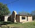 The teacherage next to the schoolhouse.
 An old adobe church.
 The Sunwest Ranch House in Lochiel.
 The monument to Fray Marcos de Niza, the first European west of the Rocky Mountains.
See also
| Wikimedia Commons has media related to Lochiel, Arizona. |
References
- 1 2 Nogales, Arizona, 30x60 Minute Topographic Quadrangle, USGS, 1994
- ↑ Massey, Peter; Welburn Wilson, Jeanne (2006). Backcountry Adventures Arizona: The Ultimate Guide to the Arizona Backcountry for Anyone With a Sport Utility Vehicle. Backcountry Adventures Series. Adler Publishing. p. 42. ISBN 9781930193284. (link returns error message)
- 1 2 3 4 5 6 James E. & Barbara H., Sherman (1969). Ghost Towns of Arizona. University of Oklahoma. ISBN 0806108436.
- 1 2 3 Barr, Betty (2006). Hidden Treasures of Santa Cruz County. BrockingJ Books. ISBN 0979026105.
- ↑ Fraser-Mackintosh, C. (1888). The Celtic Magazine: A Monthly Periodical Devoted to the Literature, History, Antiquities, Folk-lore, Traditions, and the Social and Material Interests of the Celt at Home and Abroad, Volume 13. A. & W. Mackenzie. pp. 466–7.
- ↑ Price, Jay M. (2004). Gateways to the Southwest: The Story of Arizona State Parks. University of Arizona Press. ISBN 0816522871.
- ↑ "Arizona State Parks: San Rafael Ranch". Retrieved 2014-12-10.
- ↑ "Archaeology Southwest: Descriptions of Important Historic Sites" (PDF). Archaeology Southwest. Retrieved 2015-02-16.
Municipalities and communities of Santa Cruz County, Arizona, United States | ||
|---|---|---|
| City |  | |
| Town | ||
| CDPs | ||
| Unincorporated communities | ||
| Ghost towns | ||