Listed buildings in Croston
Croston is a civil parish in the Borough of Chorley, Lancashire, England. The parish contains 42 buildings that are recorded in the National Heritage List for England as designated listed buildings. Of these, one is listed at Grade II*, the middle grade, and the others are at Grade II, the lowest grade. The parish contains the village of Croston, and this is surrounded by agricultural land. Passing through the parish are the River Yarrow and the new cut of the River Douglas. Most of the listed buildings are farmhouses, farm buildings, and houses, some of which originated as farmhouses. The other listed buildings include churches, almshouses, a village cross, public houses, a school, bridges, a former rectory and associated structures, and a telephone kiosk.
Key
| Grade | Criteria[1] |
|---|---|
| II* | Particularly important buildings of more than special interest |
| II | Buildings of national importance and special interest |
Buildings
| Name and location | Photograph | Date | Notes | Grade |
|---|---|---|---|---|
| St Michael's Church 53°39′34″N 2°46′23″W / 53.65950°N 2.77315°W |
 |
15th century | The oldest part is the tower, with most of the church dating from the 16th century, and later alterations. It is built in sandstone, and consists of a nave, a chancel, both with aisles, a south porch, and a large west tower that is mainly embraced by the nave. The tower is in four stages, it has buttresses and contains a west door and window, clock faces on the north and south sides, and louvred bell openings. At the top is an embattled parapet with corner and intermediate pinnacles.[2][3] | II* |
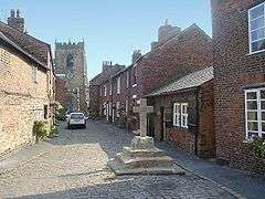
| Cross 53°39′37″N 2°46′25″W / 53.66016°N 2.77349°W |
 |
16th or 17th century (probable) | The village cross is in Church Street. It is in stone and has a base of four square steps, which are surmounted by a restored modern cross.[4] | II |
| 35 Grape Lane 53°39′30″N 2°46′08″W / 53.65829°N 2.76896°W |
— |
17th century (or earlier) |
Formerly a farmhouse, it is cruck-framed with rendered brick cladding and a thatched roof. The house has 1 1⁄2 storeys and three bays, with modern extensions at the right and the rear. The windows are casements, those in the upper floor in dormers. Inside the house are two full cruck trusses with wattle and daub infill.[5][6] | II |
| 46 Town Road 53°39′39″N 2°46′29″W / 53.66074°N 2.77461°W |
— |
17th century | The house is in stuccoed brick on a high stone plinth with a stone-slate roof. There are two storeys and two bays, with the gable end facing the road; this contains a doorway and casement windows.[7] | II |
| 66 and 68 Town Road, 2 Church Street 53°39′36″N 2°46′24″W / 53.66013°N 2.77324°W |
— |
17th century (or earlier) |
Originally a farmhouse, later extended and used as two shops and a house. The building is mainly in brick, partly roughcast, with some sandstone and with slate roofs. There are two storeys and a front of five bays. On the front are two gables, two shop fronts, a round-headed doorway with a keystone and a fanlight, and sash windows. Inside No. 66 is extensive timber-framing.[8] | II |
| Lord Nelson public house 53°39′41″N 2°46′26″W / 53.66151°N 2.77399°W |
 |
17th century | The building was extended in the 18th and 19th centuries. It is in stuccoed brick on a stone plinth with stone-slate roofs, and has two storeys. The main block, dating from the 18th century has two bays and a central doorway. The gabled wing to the right is from the 17th century; both parts contain sash windows. The 19th-century wing is behind the first bay of the main block. Inside the 17th-century wing is an inglenook and a bressumer.[9] | II |
| Rectory 53°39′35″N 2°46′20″W / 53.65962°N 2.77223°W |
— |
17th century (probable) | The rectory was remodelled in 1722, giving it a Baroque front. It is built in stuccoed brick and has a slate roof. There are three storeys and a seven-bay front. In the centre three bays is a large bow window with a doorway having an architrave of Corinthian semi-columns and an open pediment containing a shield. Each pair of outer bays has a Dutch gable. The windows are sashes.[10][11] | II |
| 53 Drinkhouse Road 53°39′30″N 2°46′48″W / 53.65842°N 2.78000°W |
— |
Late 17th century (probable) | Formerly a farmhouse, it is in painted brick on a stone base with a tiled roof. There are two storeys and two bays, with a segmental-headed doorway to the left. The windows on the front are casements, and there is a mullioned window at the rear. Inside are an inglenook fireplace and a bressumer.[12] | II |
| Bridge End Farmhouse 53°39′19″N 2°48′44″W / 53.65532°N 2.81213°W |
— |
Late 17th century (probable) | The farmhouse is in roughcast brick on a stone plinth. It has two storeys and is in a T-shaped plan, with a wing added to the rear of the original building. The original part has two bays and a slate roof, the wing is in a single bay with a red tiled roof. Inside the original part is a large inglenook fireplace and a bressumer.[13] | II |
| Hey House Farmhouse 53°39′30″N 2°47′00″W / 53.65846°N 2.78343°W |
— |
Late 17th or early 18th century | A brick farmhouse with a slate roof in two storeys and three bays. On the front is a single-storey gabled porch, and the glazing has been altered. Inside are back-to-back inglenook fireplaces.[14] | II |
| Town Bridge 53°39′37″N 2°46′26″W / 53.66022°N 2.77375°W |
 |
1682 | A public road bridge carrying The Hillocks over the River Yarrow. It is in sandstone, and consists of a single segmental arch. The bridge has rounded coping to the parapets, and a humped deck paved with setts. On the apex of the west parapet is a stone carved with the date. The bridge is also a scheduled monument.[15][16][17] | II |
| 129 and 133 Station Road 53°39′44″N 2°46′30″W / 53.66232°N 2.77498°W |
— |
1692 | Originally three almshouses, later converted into two cottages. They are in sandstone with a stone-slate roof and have a single storey and three bays. On the front are two doorways, four casement windows, and a triangular-headed inscribed stone plaque.[18] | II |
| Barn, Town Road 53°39′36″N 2°46′23″W / 53.66013°N 2.77307°W |
— |
c. 1700 (probable) | A brick barn with a slate roof, it is in two storeys and two bays. On the front are garage doors, a blocked doorway and a loading door above.[19] | II |
| 13 and 15 Church Street 53°39′35″N 2°46′25″W / 53.65980°N 2.77349°W |
— |
1704 | A house, later divided into two dwellings, in brick with a stone-slate roof. There are three storeys and two bays. On the front is a carved stone cartouche. Most of the windows are sashes, with casement windows in the left gable end.[20] | II |
| 1 and 3 Out Lane 53°39′43″N 2°46′25″W / 53.66195°N 2.77361°W |
— |
1705 | Originally a farmhouse and a barn, later converted into two houses, they are in brick, partly rendered and partly roughcast, and have thatched roofs covered in asbestos tiles. The houses are in two storeys, No. 1, the former farmhouse, has two bays, and No. 3, formerly the barn, has a single bay. All the openings have been altered. Inside No. 1 is a timber-framed partition.[21] | II |
| Ha-ha 53°39′34″N 2°46′20″W / 53.65938°N 2.77215°W |
— |
Early 18th century (probable) | The ha-ha is in the garden of the Rectory and forms its southern border. It is constructed in stone and runs along a long concave curved line.[22] | II |
| Sundial 53°39′34″N 2°46′19″W / 53.65943°N 2.77191°W |
— |
Early 18th century (probable) | The sundial is in the garden of the Rectory. It is in stone, and consists of a vase-shaped pedestal on which are a worn plate and a scrolled gnomon.[23] | II |
| Great Hanging Bridge 53°39′20″N 2°48′31″W / 53.65558°N 2.80872°W |
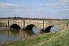 |
Early to mid 18th century (probable) | The bridge carries Meadow Lane (A581 road) over a new cut of the River Douglas. It is in sandstone and consists of three elliptical arches with triple keystones, rounded cutwaters, and pilastered piers.[15][24] | II |
| Hanging Bridge Farmhouse 53°39′17″N 2°48′43″W / 53.65478°N 2.81192°W |
— |
Early to mid 18th century | A former farmhouse in pebbledashed brick with a slate roof. It has two storeys, and an almost symmetrical two-bay front. On the front is a gabled porch that has a rounded arch with a keystone. There are two segmental-headed casement windows with lattice glazing on each floor.[25] | II |
| Barn, Bridge End Farm 53°39′20″N 2°48′44″W / 53.65549°N 2.81223°W |
— |
18th century | The barn is in brick with a slate roof, and has four bays. On the south side is a segmental-headed wagon entrance. The barn also contains altered windows, blocked ventilation slits, and an inserted garage door.[26] | II |
| 1 Church Street 53°39′37″N 2°46′25″W / 53.66019°N 2.77358°W |
— |
Mid 18th century (probable) | A brick house with a slate roof, it has an L-shaped plan, with two storeys and two bays, the right bay projecting forward. There is a doorway in the angle. One window is fixed, and the others are casements. On the right side are two blocked openings.[27] | II |
| Gateway to Rectory 53°39′36″N 2°46′17″W / 53.66008°N 2.77140°W |
 |
18th century (probable) | The gateway is in sandstone and consists of three arches, the middle one broken. The outer arches have ogee heads with traces of windows above. They appear ruinous, possibly deliberately.[15][28] | II |
| 57 Town Road 53°39′38″N 2°46′26″W / 53.66055°N 2.77385°W |
— |
Late 18th century (probable) | A brick house with a stone-slate roof, it has an L-shaped plan, with two storeys, a three-bay front, and a rear wing. The doorway has fluted pilasters and a triangular head. The windows are sashes, those in the upper floor having keystones. There is a porch on the right side in the angle of the protruding rear wing.[29] | II |
| 59 and 61 Town Road 53°39′38″N 2°46′25″W / 53.66047°N 2.77367°W |
— |
Late 18th century | A pair of cottages, one later used as a shop, in brick with a stone-slate roof. They have two storeys, and each cottage has a one-bay front. No. 59 has a shop front in the ground floor. The other windows are casements imitating sashes.[30] | II |
| 63 and 65 Town Road 53°39′37″N 2°46′25″W / 53.66040°N 2.77351°W |
— |
Late 18th century (probable) | Two brick houses with a slate roof in two storeys. No. 65 has two bays and a central round-headed doorway with a triple keystone. No. 63 has one bay and a segmental-headed doorway to the left. All the windows are sashes. At the rear of No. 63 is a hoist canopy.[31] | II |
| The Grapes Hotel 53°39′37″N 2°46′24″W / 53.66033°N 2.77336°W |
 |
Late 18th century | The public house was extended in the 19th century. It is in rendered brick with stone dressings and has roofs partly in slate and partly tiled. The building has two storeys, and the 19th-century part faces the road with a symmetrical three-bay front including a central doorway and sash windows. Behind is a long 18th-century wing in three bays, with windows of varying types.[32] | II |
| The Lodge, Grape Lane 53°39′37″N 2°46′13″W / 53.66015°N 2.77031°W |
— |
Late 18th century | A brick house, the front painted, with a slate roof. It has two storeys with attics, and a symmetrical five-bay front. In the centre is a porch with two Tuscan columns, two half-columns, and a flat cornice. The windows on the front are segmental-headed sashes. To the left is lower two-storey extension, and at the rear is a stair window and a latrine turret.[33] | II |
| Yarrow Cottage 53°39′32″N 2°46′24″W / 53.65895°N 2.77336°W |
— |
c. 1800 | A house in roughcast brick with a hipped slate roof, it has two storeys and is symmetrical with three bays on each side. There are service extensions at the rear and on the left side. The central doorway has a semicircular fanlight, and the windows are sashes. On the right side is a small bay window.[34] | II |
| Jubilee Almshouses 53°39′38″N 2°46′53″W / 53.66056°N 2.78129°W |
— |
1809 | Four almshouses in painted brick on a stuccoed stone base with a hipped slate roof. The almshouses have a symmetrical front, they are in a single storey, with the roof carried down as a verandah at the front and sides. In the centre is a pedimented gable.[35][36] | II |
| 3, 5, 7, 9 and 11 Church Street 53°39′36″N 2°46′25″W / 53.65994°N 2.77355°W |
 |
Early 19th century (probable) | A row of five brick cottages with slate roofs. They are in two storeys, No. 7 has two bays and the other cottages have one bay each. Most of the windows are sashes.[37] | II |
| 4, 6, 8 and 10 Church Street 53°39′36″N 2°46′24″W / 53.65996°N 2.77334°W |
— |
Early 19th century | A row of four brick cottages with slate roofs in two storeys, with doorways approached by three steps. Nos. 6, 8 and 10 have cellars, Nos. 4 and 10 have sash windows, and Nos. 6 and 8 have casement windows.[38] | II |
| 38 and 38A Drinkhouse Lane 53°39′30″N 2°46′46″W / 53.65833°N 2.77935°W |
— |
Early 19th century | Originally one house, later divided into two, in red and yellow brick with a tiled roof. There are two storeys, and each house has a single-bay front. In the centre are paired doorways with Tuscan architraves including engaged columns with fluted entablatures, dentilled open pediments, and semicircular fanlights. There are four windows, three are sashes and the other is a casement. Above the doorways is a blind window decorated with a rhombus.[39] | II |
| 21 and 23 Grape Lane 53°39′33″N 2°46′12″W / 53.65914°N 2.76997°W |
— |
Early 19th century | A pair of brick houses with a slate roof, in three storeys and four bays. No. 21 has a gabled porch, a semicircular fanlight, and sash windows. No. 23 has a round-headed doorways and varied windows.[40] | II |
| 73 Town Road 53°39′37″N 2°46′22″W / 53.66026°N 2.77283°W |
— |
Early 19th century | A brick house with a stone-slate roof in two storeys with a symmetrical two-bay front. The central doorway has a wooden doorcase with a pediment, and the windows are sashes with stone sills and heads.[41] | II |
| Smithy 53°39′36″N 2°46′25″W / 53.66010°N 2.77358°W |
|
Early 19th century (probable) | The former smithy is in brick with a slate roof. It is a small building with a rectangular plan in a single storey. At the left end is a full height door, there is another door in the centre, and a pair of windows to the right.[42] | II |
| School 53°39′34″N 2°46′25″W / 53.65939°N 2.77363°W |
 |
1827 | The school is in sandstone with slate roofs and is in Tudor style. It is in three parts canted around the edge of the churchyard. The main block has two storeys and three bays with a central archway. To the left is a single-storey wing; both these parts have mullioned windows. The right wing has two storeys and contains windows with altered glazing and two datestones.[15][43] | II |
| 16 Church Street 53°39′35″N 2°46′24″W / 53.65975°N 2.77331°W |
— |
Mid 19th century (probable) | A brick house with stone dressings and a hipped slate roof. It has two storeys and two bays. To the left is a doorway with a stone doorcase, and to the left of this is a partly blocked doorway containing a window. There are two windows in each floor containing replaced casements. The doorway and windows have hood moulds.[44] | II |
| The Lodge, Highfield Road 53°39′41″N 2°45′58″W / 53.66148°N 2.76603°W |
— |
Mid 19th century | Built as the lodge to Croston Hall (now demolished) and attributed to E. W. Pugin. It is in Gothic style, constructed in red brick with stone dressings, and has a blue tile roof with decorative banding and crested ridge tiles. The lodge has a T-shaped plan, consisting of a two-storey main range and a single-storey service wing at the rear. There are two bays on the front, and a porch with a decorated gablet. The windows have arched heads, and in the south front is a bay window, a sash window, a gable with bargeboards, and a finial.[5][45] | II |
| Holy Cross Chapel 53°39′23″N 2°46′09″W / 53.65642°N 2.76926°W |
 |
1857 | Built as a private chapel for Croston Hall, and designed by E. W. Pugin, it has since been used as a Roman Catholic church. The chapel is in sandstone with a slate roof, and is in eclectic Gothic style. It is a small building, consisting of a nave, a west porch, a chancel, and offices on the north side. On the west gable is a three-stage bellcote.[15][46] | II |
| Jubilee Almshouses (continuation) 53°39′37″N 2°46′53″W / 53.66027°N 2.78144°W |
— |
1870 | A row of three brick almshouses in a single storey. They have a hipped slate roof carried down to form a verandah carried on cast iron posts along the front. On the front are three doorways and four windows, all segmental-headed, the windows being casements. Also on the front is an inscribed stone plaque.[5][47] | II |
| 12 and 14 Church Street 53°39′35″N 2°46′24″W / 53.65983°N 2.77333°W |
— |
Late 19th century | A pair of brick cottages with slate roofs, in two storeys. The doorways are at the outer ends, and approached up two steps. There is a sash window in each floor. All the openings have arched heads, those in the upper floor breaking through the eaves and gabled.[48] | II |
| Telephone kiosk 53°39′44″N 2°46′30″W / 53.66222°N 2.77506°W |
— |
1935 | A K6 type telephone kiosk, designed by Giles Gilbert Scott. Constructed in cast iron with a square plan and a dome, it has three unperforated crowns in the top panels.[49] | II |
References
Citations
- ↑ Historic England
- ↑ Hartwell & Pevsner (2009), pp. 262–264
- ↑ Historic England (1163631)
- ↑ Historic England (1318153)
- 1 2 3 Hartwell & Pevsner (2009), p. 266
- ↑ Historic England (1163750)
- ↑ Historic England (1072554)
- ↑ Historic England (1163917)
- ↑ Historic England (1072552)
- ↑ Hartwell & Pevsner (2009), pp. 264–265
- ↑ Historic England (1072548)
- ↑ Historic England (1362105)
- ↑ Historic England (1072551)
- ↑ Historic England (1163665)
- 1 2 3 4 5 Hartwell & Pevsner (2009), p. 265
- ↑ Historic England (1362107)
- ↑ Historic England (1005111)
- ↑ Historic England (1163839)
- ↑ Historic England (1072557)
- ↑ Historic England (1163616)
- ↑ Historic England (1318065)
- ↑ Historic England (1362106)
- ↑ Historic England (1163685)
- ↑ Historic England (1163803)
- ↑ Historic England (1318079)
- ↑ Historic England (1362108)
- ↑ Historic England (1362103)
- ↑ Historic England (1163726)
- ↑ Historic England (1163861)
- ↑ Historic England (1072555)
- ↑ Historic England (1163888)
- ↑ Historic England (1072556)
- ↑ Historic England (1318104)
- ↑ Historic England (1072544)
- ↑ Hartwell & Pevsner (2009), pp. 265–266
- ↑ Historic England (1072553)
- ↑ Historic England (1072545)
- ↑ Historic England (1163625)
- ↑ Historic England (1163655)
- ↑ Historic England (1072550)
- ↑ Historic England (1163975)
- ↑ Historic England (1163607)
- ↑ Historic England (1072547)
- ↑ Historic England (1362104)
- ↑ Historic England (1391179)
- ↑ Historic England (1072549)
- ↑ Historic England (1362102)
- ↑ Historic England (1072546)
- ↑ Historic England (1249244)
Sources
- Historic England, "Church of St. Michael, Croston (1163631)", National Heritage List for England, retrieved 30 January 2015
- Historic England, "Cross in Church Street opposite the Smithy, Croston (1318153)", National Heritage List for England, retrieved 12 February 2015
- Historic England, "No. 35 Grape Lane, Croston (1163750)", National Heritage List for England, retrieved 31 January 2015
- Historic England, "No. 46 Town Road, Croston (1072554)", National Heritage List for England, retrieved 30 January 2015
- Historic England, "Nos. 66 and 68 Town Road, No. 2 Church Street, Croston (1163917)", National Heritage List for England, retrieved 31 January 2015
- Historic England, "The Lord Nelson Public House, Croston (1072552)", National Heritage List for England, retrieved 30 January 2015
- Historic England, "Rectory, Croston (1072548)", National Heritage List for England, retrieved 30 January 2015
- Historic England, "No. 53 Drinkhouse Road, Croston (1362105)", National Heritage List for England, retrieved 12 February 2015
- Historic England, "Bridge End Farmhouse, Croston (1072551)", National Heritage List for England, retrieved 30 January 2015
- Historic England, "Hey House Farmhouse, Croston (1163665)", National Heritage List for England, retrieved 31 January 2015
- Historic England, "Town Bridge, Croston (1362107)", National Heritage List for England, retrieved 12 February 2015
- Historic England, "Croston Town Bridge (1005111)", National Heritage List for England, retrieved 12 February 2015
- Historic England, "Nos. 129 and 133 Station Road, Croston (1163839)", National Heritage List for England, retrieved 31 January 2015
- Historic England, "Barn attached at left end of No. 68 Town Road, Croston (1072557)", National Heritage List for England, retrieved 30 January 2015
- Historic England, "Nos. 13 and 15 Church Street, Croston (1163616)", National Heritage List for England, retrieved 30 January 2015
- Historic England, "Nos. 1 and 3 Out Lane, Croston (1318065)", National Heritage List for England, retrieved 12 February 2015
- Historic England, "Ha-ha forming southern boundary of garden of Rectory, Croston (1362106)", National Heritage List for England, retrieved 12 February 2015
- Historic England, "Sundial c.50 metres south east of Croston Rectory (1163685)", National Heritage List for England, retrieved 31 January 2015
- Historic England, "Great Hanging Bridge, Croston (1163803)", National Heritage List for England, retrieved 31 January 2015
- Historic England, "Hanging Bridge Farmhouse, Croston (1318079)", National Heritage List for England, retrieved 12 February 2015
- Historic England, "Barn c.20 metres north of Bridge End Farmhouse, Croston (1362108)", National Heritage List for England, retrieved 12 February 2015
- Historic England, "No. 1 Church Street, Croston (1362103)", National Heritage List for England, retrieved 12 February 2015
- Historic England, "Gateway to Croston Rectory (1163726)", National Heritage List for England, retrieved 31 January 2015
- Historic England, "No. 57 Town Road, Croston (1163861)", National Heritage List for England, retrieved 31 January 2015
- Historic England, "Nos. 59 and 61 Town Road, Croston (1072555)", National Heritage List for England, retrieved 30 January 2015
- Historic England, "Nos. 63 and 65 Town Road, Croston (1163888)", National Heritage List for England, retrieved 31 January 2015
- Historic England, "The Grapes Hotel, Croston (1072556)", National Heritage List for England, retrieved 30 January 2015
- Historic England, "The Lodge, Croston (1318104)", National Heritage List for England, retrieved 12 February 2015
- Historic England, "Yarrow Cottage, Croston (1072544)", National Heritage List for England, retrieved 30 January 2015
- Historic England, "The Almshouses, Croston (1072553)", National Heritage List for England, retrieved 30 January 2015
- Historic England, "Nos. 3, 5, 7, 9 and 11 Church Street, Croston (1072545)", National Heritage List for England, retrieved 30 January 2015
- Historic England, "Nos. 4, 6, 8 and 10 Church Street, Croston (1163625)", National Heritage List for England, retrieved 30 January 2015
- Historic England, "Nos. 38 and 38A Drinkhouse Road, Croston (1163655)", National Heritage List for England, retrieved 31 January 2015
- Historic England, "Nos. 21 and 23 Grape Lane, Croston (1072550)", National Heritage List for England, retrieved 30 January 2015
- Historic England, "No. 73 Town Road, Croston (1163975)", National Heritage List for England, retrieved 12 February 2015
- Historic England, "The Smithy, Croston (1163607)", National Heritage List for England, retrieved 30 January 2015
- Historic England, "School in churchyard of Church of St. Michael, Croston (1072547)", National Heritage List for England, retrieved 30 January 2015
- Historic England, "No. 16 Church Street, Croston (1362104)", National Heritage List for England, retrieved 12 February 2015
- Historic England, "The Lodge, Croston (1391179)", National Heritage List for England, retrieved 12 February 2015
- Historic England, "Roman Catholic Church of the Holy Cross, Croston (1072549)", National Heritage List for England, retrieved 30 January 2015
- Historic England, "Continuation of Jubilee Almshouses, Croston (1362102)", National Heritage List for England, retrieved 12 February 2015
- Historic England, "Nos. 12 and 14 Church Street, Croston (1072546)", National Heritage List for England, retrieved 30 January 2015
- Historic England, "K6 Telephone Kiosk outside No. 1 Town Road, Croston (1249244)", National Heritage List for England, retrieved 12 February 2015
- Historic England, Listed Buildings, retrieved 31 March 2015
- Hartwell, Clare; Pevsner, Nikolaus (2009) [1969], Lancashire: North, The Buildings of England, New Haven and London: Yale University Press, ISBN 978-0-300-12667-9