Listikot
| Listikot लिस्तिकोट | |
|---|---|
| Village development committee | |
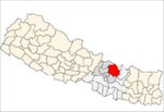
 Listikot Location in Nepal | |
| Coordinates: 27°55′N 85°52′E / 27.92°N 85.87°ECoordinates: 27°55′N 85°52′E / 27.92°N 85.87°E | |
| Country |
|
| Zone | Bagmati Zone |
| District | Sindhupalchok District |
| Population (1991) | |
| • Total | 3,664 |
| • Religions | Hindu |
| Time zone | Nepal Time (UTC+5:45) |
Listikot is a village in Sindhupalchok District in the Bagmati Zone of central Nepal. At the time of the 1991 Nepal census it had a population of 3664 and had 714 houses in the village.[1]
References
- ↑ "Nepal Census 2001". Nepal's Village Development Committees. Digital Himalaya. Retrieved 2008-08-24.
Its surrounded by kaverepalnchhok, ramechap, rasuwa and china on north, most of the people are agriculture and some are business. Most of the population are Sherpa family and most of the population from Buddhism religion. VDC ward # are as below, 1. Kanglang 2. Darapani 3. Changshing 4. Gumba 5. Valdong 6. Listi 7. Chhagam 8. Bagham 9. Ghipche
This article is issued from Wikipedia - version of the 8/31/2015. The text is available under the Creative Commons Attribution/Share Alike but additional terms may apply for the media files.