Little Barrier Island
| Māori: Te Hauturu-o-Toi Nickname: Hauturu | |
|---|---|
|
View from the mainland | |
 Little Barrier Island | |
| Geography | |
| Location | Hauraki Gulf, Auckland Region |
| Area | 28 km2 (11 sq mi) |
| Length | 7.5 km (4.66 mi) |
| Width | 5.5 km (3.42 mi) |
| Highest elevation | 722 m (2,369 ft) |
| Highest point | Mount Hauturu |
| Administration | |
| Demographics | |
| Population | No permanent inhabitants |
| Additional information | |
| Wildlife sanctuary | |
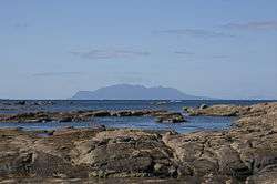
Little Barrier Island, or Hauturu in Māori language[1] (the official Māori title is Te Hauturu-o-Toi[2]), lies off the northeastern coast of New Zealand's North Island. Located 80 kilometres (50 mi) to the north of Auckland, the island is separated from the mainland to the west by Jellicoe Channel, and from the larger Great Barrier Island to the east by Cradock Channel. The two aptly named islands shelter the Hauraki Gulf from many of the storms of the Pacific Ocean.
Settled by the Maori sometime between 1350 and 1650, the island was occupied by those people until the New Zealand government declared the islands a wildlife sanctuary in 1897. Since the island came under control of the government, it has been under limited access, with only a few rangers living on the island. In the Māori language, the name of the island name means "the resting place of lingering breezes".[1] Along with its larger neighbour Great Barrier, it was given its English name by Captain James Cook in 1769.[3]
The island is a nature sanctuary which has been described by the MBIE as "the most intact [native] ecosystem in New Zealand".[4] However, several invasive species were introduced by both Maori and European settlers, including cats which are destructive to local small bird and reptile species.
History
Māori occupied the island for centuries prior to the first European visits, probably first settling on the island between 1350 and 1650 CE.[5] The initial occupation was by descendants of Toi te Huatahi, followed by Tainui who were then conquered by the Ngāti Wai. Only a few Ngāti Wai were still living on the island by 1881 and the British Crown attempted to buy the island in order to turn it into a nature reserve.[6] When this purchase fell through, the island was instead appropriated through an Act of Parliament in 1894 and became New Zealand's first nature reserve the following year.[6] Since 1897, there has always been a caretaker or ranger resident on the island.[1]
Access is heavily restricted for conservation reasons, and the island is uninhabited except for rotational conservation staff, scientists and rangers under the authority of the Department of Conservation. Electricity for their needs, provided until 2005 by a diesel generator linked to a battery bank, has since been replaced by twenty 175-watt solar panels, with the generator remaining solely for backup. Over the expected 20-year life-span, the system is expected to generate fuel savings sufficient to replace its purchase costs.[4]
Stonework
Māori stonework has been found in fourteen locations on the island, primarily around the coastal flats at Te Titoki Point. Man-made cuttings, which were described in 1895 as ruts for hauling canoes, can be seen on the boulder beach ridge at Te Titoki Point. There are also stone rows measuring up to 60 metres (200 ft) long, 2 metres (6 ft 7 in) wide and 0.5 metres (1 ft 8 in) high, located near the mouth of Te Waikohare Stream.[7]
Stone rows and heaps can be found 200 metres (660 ft) to 500 metres (1,600 ft) from the mouths of Te Waikohare and Tirikawa Streams. The largest is 2 metres (6 ft 7 in) high and 4 metres (13 ft) wide. The most extensive stonework is located in the northwest of the island, near the ridge south of Te Hue Stream, where it is spread over several hectares. This site includes a number of terraces, which are stone-faced or have stone retaining walls. There are also numerous stone heaps and rows, and several free standing stone walls.[7]
Stonework in the northeast of the island is more weathered than in other areas and partially buried. Because of this weathering these features are thought to be older than at the other sites.[7]
Geography
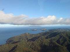
The island is an extinct andesitic volcanic cone, roughly circular in shape, about 6 km (3.7 mi) across, with an area of 28 km2 (11 miles2). Its earliest volcanic activity is estimated to have occurred 3 million years ago and the latest 1.2 million years ago. The volcano is most closely related to two volcanoes over 120 km (75 mi) northwest, near Whangarei.[8] The island is steeply sloping, and deeply dissected by ravines radiating from a central range that peaks at Mount Hauturu whose altitude is 722 m (2,369 ft).[9] Te Titoki Point is the only area of flat land on the island.[10]
Environment
A dense forest cover shelters numerous rare or endangered animal species.[1] The total number of species of native plants is thought to range around 400, and the island may shelter more endangered birds than any other island in New Zealand.[4] The island has been identified as an Important Bird Area by BirdLife International because it is a nesting site for vulnerable Cook's and Parkinson's petrels.[11] In February 2013, there were reports of the critically endangered New Zealand storm petrel (Oceanites maorianus) breeding on the island.[12]

When the island the Māori occupied the island, as much as a third of the island was cleared of forest. However, since the acquisition of the land by the New Zealand government, all but 20 hectares of the island have been reforested.[5]
Bryde's whales, Orcas and Bottlenose dolphins live in the waters around the island. Blue whale[13] and Southern right whales rest in this area during migration.[14] In 2012, there were reports that a southern right whale may have calved near the island.[15][16]
Invasive species
Several small rodents were likely introduced as invasive species during the initial settlement of the island by the Māori peoples, including the Pacific rat or kiore (Rattus exulans).[5]
Feral cats arrived on the island in the early 1870s.[5] As in other places where predatory species were introduced, small animals not accustomed to predation likely experienced a decline in population, being pushed towards endangerment or extinction.[5] In survey of studies about eradicating the cats, scientist C.R. Veitch mentions several small species which were likely affected by the cats, including small reptiles and birds, such as the little barrier snipe (Coenocorypha aucklandica barrierensis), North Island saddleback (Philesturnus carunculatus rufusater), grey-faced petrel (Pterodroma macroptera gouldi), Cook's petrel (Pterodroma cookii) and black petrel (Proeellaria parkinsoni).[5] In 1977, 151 cats were killed using traps and poison.[5]
See also
References
- 1 2 3 4 "The Hauraki Gulf Marine Park, Part 2". Inset to The New Zealand Herald. 3 March 2010. p. 15.
- ↑ "Islands and bays renamed in Maori". stuff.co.nz. 2011. Retrieved 7 June 2011.
Te Hauturu-o-Toi
- ↑ "Chronology of events" (PDF). Retrieved 13 September 2012.
- 1 2 3 "New Zealand Energy Quarterly, March 2010" (PDF). 16 June 2010. Retrieved 8 July 2010.
- 1 2 3 4 5 6 7 Veitch, C. R. (2001). "The eradication of feral cats (Felis catus) from Little Barrier Island, New Zealand". New Zealand Journal of Zoology. 28: 1–12. doi:10.1080/03014223.2001.9518252.
- 1 2 "Features: Little Barrier Island Nature Reserve (Hauturu-o-Toi)". Department of Conservation (New Zealand). Retrieved 8 September 2012.
- 1 2 3 W. Hayward, Bruce (1982). "Prehistoric archaeological sites on Little Barrier Island, New Zealand" (PDF). New Zealand Geological Survey. pp. 73–75. Retrieved 13 September 2012.
- ↑ Lindsay, Jan M.; Tim J. Worthington; Ian E. M. Smith; Philippa M. Black (June 1999). "Geology, petrology, and petrogenesis of Little Barrier Island, Hauraki Gulf, New Zealand". New Zealand Journal of Geology and Geophysics. 42 (2): 155–168. doi:10.1080/00288306.1999.9514837. Retrieved 21 September 2012.
- ↑ "Topo50 map AY33 – Hauturu / Little Barrier Island". Land Information New Zealand. Retrieved 6 March 2010.
- ↑ "Map of Hauturu Little Barrier Island" (Topo Map). Rimutaka Forest Park Trust.
- ↑ "Important Bird Areas: Little Barrier Island". Birdlife International. Retrieved 22 September 2012.
- ↑ "New Zealand Storm-petrel discovered breeding 50 km from Auckland City". BirdLife International. 25 February 2013. Retrieved 26 February 2013.
- ↑ "Blue Whales". Archived from the original on 12 March 2011.
- ↑ "Newsletter, Issue 26th November 2011" (PDF). Hauturu, Little Barrier Island Supports Trust. Retrieved 26 April 2014.
- ↑ "Rare whale sighting off Auckland coast". 3news.co.nz.
- ↑ Tony and Jenny Enderby. "New Zealand marine life". newzealandmarinelife.blogspot.jp.
External links
- Kermode, Leslie Owen (1966). Little Barrier Island, An Encyclopaedia of New Zealand.
- Department of Conservation – Little Barrier Island (Hauturu) Nature Reserve
- Cultural Heritage of the Gulf (brief history on page 5)
Coordinates: 36°11′57″S 175°04′53″E / 36.1990923°S 175.0814295°E