Little Sur River
| Little Sur River | |
| River | |
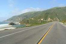
 View of Little Sur River outlet from Highway 1 | |
| Country | |
|---|---|
| State | California |
| Region | California Central Coast |
| County | Monterey County |
| Tributaries | |
| - left | Skinners Creek (North Fork), Comings Creek (North Fork), Puerto Suelo Creek (North Fork), Launtz Creek (South Fork) |
| - right | Ventana Creek (North Fork) |
| Source | Ventana Double Cone |
| - elevation | 4,853 ft (1,479 m) |
| - coordinates | 36°17′49″N 121°42′49″W / 36.29694°N 121.71361°W |
| Mouth | Pacific ocean |
| - elevation | 0 ft (0 m) |
| - coordinates | 36°20′05″N 121°53′22″W / 36.33472°N 121.88944°WCoordinates: 36°20′05″N 121°53′22″W / 36.33472°N 121.88944°W |
| Length | 14.3 mi (23 km) |
The Little Sur River and its South Fork tributary comprise a 25.4 miles (40.9 km)[1]:166 long river on the Central Coast of California. They drain a watershed of about 40 square miles (100 km2) of the Big Sur area, a thinly settled region of the Central California coast where the Santa Lucia Mountains rise abruptly from the Pacific Ocean. The South Fork and the North Fork both have their headwaters in the Ventana Wilderness, straddling Mount Pico Blanco. Portions west of the national forest and Old Coast Road lie within the El Sur Ranch. The forks converge about 2 miles (3.2 km) before the river empties into the Pacific Ocean.
The river's steep canyons and high chaparral-covered ridges are host to a number of rare species including the Santa Lucia Fir, Dudley's lousewort, and virgin stands of old-growth redwood.
Little Sur River watershed
Watershed quality
In 1973 the California State Legislature, recognizing the river's "extraordinary scenic, fishery, wildlife, (and) outdoor recreational values" and to protect its "free-flowing and wild status,"[2] added the river to the California Protected Waterways System.[3]:357 Responding to the state's request, in 1981 Monterey County added the river to its Protected Waterways Management Plan and encouraged the state in its Big Sur Coast Land Use Plan to designate the Little Sur area as a "coastal resource of national significance."[2]:46[3]:357
Wildlife
The Little Sur River watershed provides habitat for mountain lion, bear, deer, fox, coyotes and wild boars. The upstream river canyon is characteristic of the Ventana Wilderness region: steep-sided, sharp-crested ridges separating valleys.[4] Because the upper reaches of the Little Sur River watershed is entirely within the Ventana Wilderness, much of the river is in pristine condition. The California Department of Fish and Game says the river is the "most important spawning stream for steelhead" on the Central Coast.[5] and that it “is one of the best steelhead streams in the county.”[1]:166 The Little Sur River is a key habitat within the Central California Steelhead distinct population segment which is listed as threatened.[6][7]
A U.S. fisheries service report estimates that the number of trout in the entire south-central coast area—including the Pajaro River, Salinas River, Carmel River, Big Sur River, and Little Sur River—have dwindled from about 4,750 fish in 1965 to about 800 in 2005. The total number of steelhead in the Little Sur River was estimated at less than 100 in 1991.[8]
Vegetation
The watershed is populated with Coastal Redwood, Douglas Fir, Western Sycamore, Bay Laurel, Bigleaf Maple, and Tanbark Oak. Mixed in with the Redwood and Douglas Fir is a riparian habitat containing Alder, poison oak, and thimbleberry. The upper slopes are usually a mix of chaparral, covered by coyote bush, ceanothus, chamise, manzanita, sagebrush, and bush lupine.[9] On a few upper slopes may be found patches of open grassland dotted with Black Oak, Canyon Live Oak, and Tanbark Oak] favored by the early Esselen inhabitants.

The Little Sur River watershed contains stands of some of the most impressive uncut Coastal Redwood trees in the entire Big Sur area,[3]:355 including specimens over 200 feet (61 m) tall.[3]:133 It also contains the largest and tallest stands of Douglas Fir on the Central Coast,[3]:215 up to 150 feet (46 m) in height.[3]:315 A stand of the rare Santa Lucia fir, described as "the rarest and most unusual fir in North America,"[3]:214 are found on Skinner's Ridge, east of Pico Blanco Boy Scout camp.
Geology
The river canyon is deep and narrow, and even in the summer sunshine only reaches the canyon bottom for a few hours. The land is mostly steep, rocky, semi-arid except for the narrow canyons, and inaccessible. The upstream river canyon is characteristic of the Ventana Wilderness region: steep-sided, sharp-crested ridges separating valleys.[4] Upstream from the Boy Scout camp are narrow gorges, waterfalls, and a few large pools.
Several northwest-trending earthquake faults cut across the Little Sur River drainage: the Sur, the Palo Colorado, and the Church Creek faults. The river flows mostly west for much of its length, unlike other rivers in the region which tend to flow to the northwest or southeast. Near Camp Pico Blanco, the river meets the Palo Colorado fault and follows it northwesterly for about 1 mile (1.6 km), before turning west towards the Pacific Ocean. The lower length of the South Fork follows the Sur fault zone until it meets the North Fork. West of the Sur fault the earth is composed of Franciscan Assemblage rocks, some exposed serpentine, and overlying sandstone. Most of the Little Sur River geology is to the east of the Sur fault. This area is marked by deep canyons cut through granitic and metamorphic rocks of the Salinian Block. Upstream from the Boy Scout camp the gorges are full of mica schist and gneiss (metamorphosed sedimentary rocks), and granodiorite, quartz monzonite, and quartz diorite (granatic rocks). At the river's mouth are some of the largest sand dunes on the Big Sur coast.[3]:355
The north and south forks of the Little Sur River straddle either side of Mount Pico Blanco, Spanish for "White Peak." It is topped by a distinctive white limestone cap, visible from California's Highway 1. The native Esselen people revered the peak as a sacred mountain from which all life originated. They believed that three creatures—the eagle, coyote and the hummingbird—rode out the Great Flood atop the mountain and went on to create the world.[10]
Mining claim
Mount Pico Blanco contains a large, pharmaceutical-grade limestone deposit known as the Pico Blanco body and the Hayfield body. It is the only high-grade deposit on the Pacific Coast outside Alaska within three miles of potential marine transportation. Reserves have been estimated to be from 600 million[11]:46 to a billion tons,[12] reportedly the largest in California,[13] and the largest west of the Rocky Mountains.[10] The Granite Rock Company of Watsonville, California bought 2,800 acres (1,100 ha), including the peak, and mineral rights to Pico Blanco in 1963. Limestone is a key ingredient in concrete. The limestone also contains a high concentration of calcium, which is used in medicines, cosmetics, food and clear glass.[14] Granite Rock owns two easements across the El Sur Ranch from the Old Coast Road, allowing it access to the limestone deposits. The Dani Ridge access road was developed as a haul road, while the other which cuts across the north face of Mount Pico Blanco, above the South Fork of the Little Sur River, has not been developed.[2] The deposit lies partly within and partly outside the national forest,[2]:46 complicating administration of the mining rights.
In 1980, Granite Rock submitted a five-year plan to the United States Forest Service and requested a permit to begin excavating a 5 acres (2.0 ha) quarry. The Forest Service prepared an Environmental Assessment of the plan and recommended some modifications, which Granite Rock implemented. Soon after Graniterock obtained the permit in 1983, the California Coastal Commission required Granite Rock to apply for a coastal development permit.[15] Granite Rock filed suit in U.S. District Court claiming that the Coastal Commission permit requirement was preempted by Forest Service regulations, by the Mining Act of 1872, and by the Coastal Zone Management Act. The district court denied Granite Rock's motion for summary judgment, and dismissed the action.
The Court of Appeals for the Ninth Circuit reversed the lower court's decision, holding that the Coastal Commission permit requirement was preempted by the Mining Act of 1872 and Forest Service regulations. The Coastal Commission appealed to the United States Supreme Court. In their ruling, California Coastal Comm'n v. Granite Rock Co., the court ruled that because Congress specifically disclaimed any intention to preempt preexisting state authority in the Coastal Zone Management Act, even if all federal lands are excluded from the act's definition of "coastal zone," the act does not automatically preempt all state regulation of activities on federal lands.[10]:282[16] Graniterock still owns the property.
Weather
The Little Sur River basin climate, protected for the most part from coastal fog by Pico Blanco, is characterized by hot, dry summers and rainy, mild winters. Annual temperatures average 50 °F (10 °C) to 65 °F (18 °C). Annual precipitation ranges from 10 to 50 inches (250 to 1,270 mm), with a pronounced summer drought. This interior is hotter than the coastal region and receives less moisture from fog in summer. Severe spring rains have caused mud slides on steep slopes above roads near the hair-pin turns, which briefly closed the road into the Pico Blanco Boy Scout camp during the spring of 1967 and 1969.[17]
Tributaries
The river originates in the area of the Ventana Double Cone and flows to the Pacific Ocean. The upper part of the river's watershed is in the Ventana Wilderness of the Los Padres National Forest. The rest, mostly near the coast, is privately owned. Precipitation increases with altitude at Big Sur. Higher elevations can receive over 50 inches (1,300 mm) per year, about 10 inches (250 mm) higher than lower areas.
The main river, locally known as the North Fork, is in a bowl-shaped watershed, fed by several creeks and surrounded by Launtz Ridge and Pico Blanco (3,709 feet (1,131 m)) to the west, Devil's Peak (4,158 feet (1,267 m)) to the north, Uncle Sam Mountain (4,766 feet (1,453 m)) to the east, and Ventana Double Cone (4,853 feet (1,479 m)) to the southeast. The North Fork flows mostly over granite bedrock. Upstream tributaries include Skinners Creek, Ventana Creek, Comings Creek, and Puerto Suelo Creek. A one-armed man named Vogler built a cabin east of Devil's Peak in the 1880s, later purchased by the Comings family, for whom the location and creek are named today. (They continued to use the cabin until the early 1950s.)[18]
The South Fork of the river flows over granite bedrock, with portions of limestone and marble bedrock. The river has eroded the limestone and marble such that it travels underground in several locations. Tributaries on the South Fork include Rocky Creek, Turner Creek, Bixby Creek, Mill Creek, and Lachance Creek, many of them named for former homesteaders like Antare P. Lachance.[19] Bixby Creek was the site of a landing built to transfer tanbark via cable to ships anchored offshore. The South Fork is unrestricted by any man-made dams, but an impassable waterfall about 12 feet (3.7 m) high 11 miles (18 km) upstream prevents steelhead from migrating further.
Boy Scout Camp
Camp Pico Blanco is at 793 feet (242 m) elevation, near the bottom of a bowl-shaped watershed, surrounded by Launtz Ridge and Pico Blanco (3,709 feet (1,131 m)) to the west, Devil's Peak (4,158 feet (1,267 m)) to the north, Uncle Sam Mountain (4,768 feet (1,453 m)) to the east, and Ventana Double Cone (4,853 feet (1,479 m)) to the southeast. Upstream tributaries include Jackson Creek, Pine Creek, Puerto Suelo Creek, and Comings Creek. A small creek enters the Little Sur River via a waterfall at the location of the seasonal reservoir in the camp proper. The immediate camp environment consists of seven distinct biotic habitats: coast redwood/mixed evergreen forest, white alder riparian woodland, herbaceous vegetation, aquatic habitat, bare alluvium, bare ground, and Sur Complex bedrock.[20]:7 The camp is accessed via the narrow and winding Palo Colorado Road, 7.6 miles (12.2 km) from the coast. Some of the redwoods in the vicinity of the camp were planted between 1910 and 1921.[21]
Boy Scout Dam on river
There is a seasonal 11 feet (3.4 m) high concrete flash board dam on the North Fork of the river in the Camp Pico Blanco. Built in 1953, it creates a small recreational reservoir about 2 acres (0.81 ha) in size. In 2002, the California Department of Fish & Game attempted to stop the Monterey Bay Area Council from using the dam. After intervention by Rep. Sam Farr and Senator Bruce McPherson, the Fish and Game retreated from preventing the council from filling the dam, but stipulated that certain regulations must be adhered to.
The National Marine Fisheries Service discovered shortly afterward that the Council appeared to have filled the dam in violation of these regulations, "dewatering" the river below the dam and killing at least 30 threatened steelhead trout. The Council could have been subject to fines of up to $360,000. The council avoided paying a fine by building a $1 million custom fish ladder[22] designed by Swanson Hydrology + Geomorphology. Don Chapin Company, a long-time supporter of the Monterey Bay Area Council, was the honoree at the 2006 dinner at which it was recognized for donating the cost of constructing the fish ladder.[23] California State Representative Sam Farr's father helped build the camp, and Farr attended the camp as a boy.[19][22]
Habitat for endangered species
A 1965 report said the stream contained about 30 miles of prime habitat for the threatened steelhead.[1]:166[24] In 2002, Fish and Game staff surveyed the Little Sur River in the vicinity of the Camp Pico Blanco and found "numerous" steelhead fry and fingerlings. They described the river as "probably the most productive steelhead river south of the San Francisco Bay at this time."[1]:166 The Little Sur River is considered by the California Department of Fish and Game to be the "most important spawning stream for Steelhead" on the Central Coast[8] and "one of the best Steelhead streams in the county."[1]:165
As of 2011, fishing is limited to the fourth Saturday each month from May through October 31 each year. Only artificial lures with barbless hooks may be used.[25]

Other at risk species found in the river's riparian corridor include the California red-legged frog (Federally threatened, California Species of Concern), Western pond turtle (California Species of Concern), Foothill yellow-legged frog (California Species of Concern), and the Coastal Range newt (California Species of Concern).[26]
Rare vegetation and wildlife
The area was first surveyed in 1905 when the region was set aside as part of the Monterey Forest Preserve. That survey noted that the redwoods achieved their maximum development along the Little Sur River.[27] The Little Sur River watershed contains stands of some of the most impressive uncut Coastal Redwood trees in the entire Big Sur area,[3]:355 including specimens over 200 feet (61 m) tall.[3]:133 It also contains the largest and tallest stands of Douglas Fir on the Central Coast,[3]:215 up to 150 feet (46 m) in height.[3]:315 A stand of the rare Santa Lucia fir, described as "the rarest and most unusual fir in North America," are found on Skinner's Ridge, east of the Camp Pico Blanco. There are also a few Ponderosa Pine in the lower canyon.[3]
The North Fork of the Little Sur River supports the largest known population found on public lands of the rare Dudley’s lousewort. Endemic to redwood forests, fewer than 10 known locations are known to support the plant.[28]
Fire impact
Fire is an integral part of the Little Sur River landscape.[4] Upper elevations are [29] typically covered by chaparral. In one of the first recorded fires in 1894, most of what is now the Monterey Ranger District, including the Little Sur River watershed, was burned by a fire that was unchecked for weeks. In October, 1905 another fire raged for more than a month, consuming all of the Palo Colorado and Pico Blanco area.[30] The Molera Fire in 1972 burned a considerable portion of the watershed, and in August, 1977, the Marble-Cone Fire burned the entire area. This was repeated in 2008 when the Basin Complex fire involved the entire watershed. In 2016, the Soberanes Fire once again burned through almost the entire Little Sur River watershed with the exception of areas west of the Old Coast Road.[31][32][33]
History
The Little Sur River area has always been sparsely occupied. The land is mostly steep, rocky, semi-arid except for the narrow canyons, and inaccessible, making long-term habitation a challenge.
Esselen tribe
The area was first occupied by the Esselen American Indians who followed local food sources seasonally, living near the coast in winter, where they harvested rich stocks of mussels, abalone and other sea life. In the summer and fall they move inland to harvest acorns gathered from the Black Oak, Canyon Live Oak and Tanbark Oak, primarily on upper slopes in areas outside the current camp's location.[3]:270 A large boulder with a dozen or more deep mortar bowls worn into it, known as a bedrock mortar, is located in Apple Tree Camp on the southwest slope of Devil's Peak, north of the Camp Pico Blanco. The holes were hollowed out by Indians who used it to grind the acorns into flour. Other mortar rocks have also been found within the Boy Scout camp at campsites 3 and 7, and slightly upstream from campsite 12, while a fourth is found on a large rock in the river, originally above the river, between campsites 3 and 4.
Pico Blanco, which splits the north and south forks of the river, was sacred in the native traditions of the Rumsien and the Esselen, who revered the mountain as a sacred place from which all life originated.[34] The Spanish mission system led to the virtual destruction of the Indian population. Estimates for the pre-contact populations of most native groups in California have varied substantially. Alfred L. Kroeber suggests a 1770 population for the Esselen of 500.[35] Sherburne F. Cook raises this estimate to 750.[36] A more recent calculation (based on baptism records and density) is that they numbered 1,185-1,285.[37]
On June 14, 1771, Father Junípero Serra founded Mission San Antonio de Padua near the current town of Jolon. By about 1822, much of the native Indian population had been forced into the Spanish mission system, and most of the interior villages within the current Los Padres National Forest were uninhabited.[38] The Esselen were absorbed into the population of Mission San Carlos Borromeo de Carmelo in present-day Carmel, California, where many died from disease, demoralization, poor food, and overwork. The last baptism of an Esselen native was recorded in 1808, and there is some evidence that some members may have escaped into the upper reaches of the Carmel and Arroyo Seco Rivers.
European settlement
Along with the rest of California, Big Sur became part of Mexico when it gained independence from Spain in 1821. On July 30, 1834, Mexican governor José Figueroa conveyed the 8,949-acre (36 km2) Rancho El Sur land grant to Juan Bautista Alvarado.[39]:21 Alvarado later traded his Rancho El Sur to his uncle by marriage, Captain John B.R. Cooper, in exchange for Rancho Bolsa del Potrero y Moro Cojo.

After California revolted against Mexican rule and became a U.S. state, a few hardy pioneer homesteaders settled in the Big Sur region, drawn by the promise of free 160 acre (0.6 km²) parcels. They filed United States government patents as early as 1891.[40] These settlers included William F. Notley, who homesteaded at the mouth of Palo Colorado Canyon in 1891.

He began harvesting tanoak bark from the canyon, a lucrative source of income at the time. The bark was used to manufacture tannic acid, necessary to the growing leather tanning industry located in Santa Cruz, about 40 miles to the north. Notley constructed a landing at the mouth of the Palo Colorado River like that at Bixby Landing to the south. The tanbark was harvested from the isolated trees inland, corded, brought out by mule back or using wooden sleds, and loaded by cable onto waiting vessels anchored offshore at Notley's Landing. A point on the Palo Colorado Road is still nicknamed "The Hoist" because of the very steep road which required wagon-loads of tanbark and lumber to be hoisted by block and tackle hitched to oxen.[41] The old block and tackle on a beam is still mounted between mailboxes.[42]
Notley's Landing was used to ship the tan bark north, and a small village prospered at that spot from 1898 to 1907.[43][44] In 1889, as much as 50,000 cords of tanbark were hauled out from the Little Sur River and Big Sur River watersheds.[3]:330 Redwood harvesting was limited by the rugged terrain and difficulty in transporting the lumber to market. Near the start of the 20th century, the tan oak trees were becoming seriously depleted, which slowly led to the demise of the industries they had created.[45]
A one-armed man named Vogler built a cabin east of Devil's Peak in the 1880s, later purchased by the Comings family, for whom the location and creek are named today. (They continued to use the cabin until the early 1950s.)[18] Other early homesteaders in the Palo Colorado Canyon region included Thomas W. Allen, 1891, Isaac N. Swetnam, 1894, Harry E. Morton, 1896, Samuel L. Trotter, 1901, Abijah C. Robbins, 1901, and Antare P. Lachance, 1904.[46] Swetnam bought the Notley home at the mouth of Palo Colorado Canyon and also constructed a small cabin on the Little Sur River at the site of the future Pico Blanco camp.
The area was very isolated and only the sturdiest and most self-sufficient settlers stayed. A wagon trail from Carmel to the Post Ranch on the Rancho El Sur was in use by about 1855.[47]:4-2 The 30 miles (48 km) trip to Carmel over a very rough and dangerous track could take three days by wagon or stagecoach.[48]:24 The single-lane road was closed in winter when it became impassable. Coast residents would occasionally receive supplies via a hazardous landing by boat from Monterey or San Francisco.[47]:4-4
In October, 1905 the land that now makes up the Los Padres National Forest, including the South Fork and portions of the upper reaches of the North Fork of the Little Sur River watershed, were withdrawn from public settlement by the United States Land Office,[30] although current landholders were allowed to retain their property. In January 1908, 39 sections of land, totaling 25,000 acres (10,000 ha), were added to the Monterey National Forest by President Theodore Roosevelt in a presidential proclamation. Several tanning companies and some homesteaders retained ownership of land within the area which were not purchased by the government.
By 1916 the Kron Tanning Company of Santa Cruz and the Eberhard Tanning Company of Santa Clara had acquired most of the acreage along the Little Sur River from the original owners. Interest in preserving the abundant growth of redwoods in the area prompted newspaper publisher William Randolph Hearst to purchase the entire acreage. On November 18, 1921, the Hearst Sunical Land and Packing Company paid approximately $50,000 to buy the land from the tanning companies.
After 18 years of construction, a paved two-lane Highway 1 was completed in 1937.[40] Prior to the construction of Highway 1, the California coast south of Carmel and north of San Simeon was one of the most remote regions in the state, rivaling nearly any other region in the United States for its difficult access.[47]
References
- 1 2 3 4 5 Becker, Gordon S.; Reining, Isabelle J. (October 2008). "Steelhead/Rainbow Trout (Oncorhynchus mykiss) Resources South of the Golden Gate, California". Center for Ecosystem Management and Restoration.
- 1 2 3 4 "Big Sur Coast Land Use Plan" (PDF). Monterey County Planning Department. February 11, 1981. Retrieved November 15, 2009.
- 1 2 3 4 5 6 7 8 9 10 11 12 13 14 15 Henson, Paul (1993). The Natural History of Big Sur (PDF). Donald J. Usner. Berkeley: University of California Press. ISBN 0-520-20510-3.
- 1 2 3 "Pico Blanco Scout Reservation" (PDF). Monterey Bay Area Council, Boy Scouts of America. Retrieved 3 July 2013.
- ↑ "Camp Pico Blanco Fish Ladder and Dam Retrofit". WaterWays Consulting. Retrieved 3 July 2013.
- ↑ "North-Central California Coast Recovery Domain 5-Year Review: Summary and Evaluation of Central California Coastal Steelhead DPS Northern California Steelhead DPS" (PDF). National Oceanic and Atmospheric Administration. 2011. Retrieved 2013-12-03.
- ↑ "Ventana Wild Rivers Campaign Little Sur River". Retrieved September 1, 2009.
- 1 2 Busby, Peggy J.; Wainwright, Gregory J. Bryant*, Lisa J. Lierheimer, Robin S. Waples, F. William Waknitz, and Irma V. Lagomarsino, Thomas C. (August 1996). "Status Review of West Coast Steelhead from Washington, Idaho, Oregon, and California". Table 21. Summary of recent and historical abundance estimates for the South-Central California Coast evolutionarily significant unit. Excludes estimates from CDFG (1965) presented in Table 17. U.S. Dept Commerce/NOAA/NMFS/NWFSC/. pp. NOAA–NWFSC Tech Memo–27: Status Review of West Coast Steelhead. Retrieved November 16, 2009.
- ↑ Harvey and Stanley Associates (August 10, 1983). "Little Sur River Protected Waterway Management Plan" (PDF). Retrieved September 1, 2009.
- 1 2 3 Elliot, Analise (2005). Hiking & Backpacking Big Sur: A Complete Guide to the Trails of Big Sur, Ventana Wilderness, and Silver Peak Wilderness (1st ed.). Berkeley, CA: Wilderness Press. ISBN 978-0-89997-326-5.
- ↑ "Big Sur Coast Land Use Plan" (PDF). Monterey County Planning Department. February 11, 1981. Retrieved 2009-11-15.
- ↑ Bowen, Oliver E.; Gray, Jr., Cliffton H.; Evans, James R. "Limestone & Dolomite Resources of California (as of 1973)". The Mineral Economics of The Carbonate Rocks: Limestone and Dolomite Resources of California Bulletin 194. California Division of Mines and Geology. Retrieved November 10, 2009.
- ↑ "SummitPost—Pico Blanco—Climbing, Hiking & Mountaineering". Retrieved November 10, 2009.
- ↑ Counts, Chris (March 12, 2010). "Not just another Big Sur mountain, Pico Blanco has quite a story to tell". Carmel Pine Cone. Retrieved 22 September 2016.
- ↑ 480 U.S. 572 (1987)
- ↑ "California: What's Yours Is Mine". Time Magazine. April 6, 1987. Retrieved November 10, 2009.
- ↑ "Slide Takes Out Camp Road". A History of Pico Blanco Scout Reservation. p. 9. Retrieved November 10, 2009.
- 1 2 Wood, Lea (Fall 2001). "The Story of Comings Cabin". Double Cone Quarterly, Volume IV, Number 3. Retrieved 2009-11-15.
- 1 2 Young, Alfred (July 1963). "Men in the Making" (PDF). Monterey Bay Area Council. Retrieved 2009-08-14.
- ↑ "Combined Development Permit" (PDF). Monterey County Planning Department. August 10, 1005. Retrieved November 15, 2009.
- ↑ "Pico Blanco Road to Little Sur River". Retrieved 4 September 2012.
- 1 2 Rosenfield, Seth (February 1, 2009). "Political pull helped fix Scouts' dam problem". San Francisco Chronicle. Retrieved 2009-08-13.
- ↑ "Best Marketing Campaign: Monterey Bay Area Council". Irving, Texas: Boy Scouts of America. 2009. Retrieved 2009-11-13.
- ↑ "Ventana Wild Rivers Campaign Little Sur River". Retrieved 2009-09-01.
- ↑ "2011-2012 Freshwater Sport Fishing Regulations". California Department of Fish and Game. Retrieved 30 October 2011.
- ↑ "Planning Commission County of Monterey, State of California, Resolution No. 05038" (PDF). August 10, 2005. Retrieved 2009-11-22.
- ↑ Plummer, Fred G.; Gowsell, M. G. (1905). "Forest Conditions in the Monterey Forest Reserve". Washington, D.C.: Department of the Interior, United States Geological Survey. Retrieved 15 August 2011.
- ↑ "California Rivers: Little Sur River". Friends of the River. Retrieved 30 October 2011.
- ↑ "Soberanes Fire: Week Three". Retrieved 12 August 2016.
- 1 2 "History of the Monterey Ranger District Part I". Double Cone Quarterly. Summer 2002. Retrieved 2009-11-11.
- ↑ "Soberanes Fire grows to 38,007 acres, remains 15 percent contained". KSBW.com. Jul 31, 2016. Retrieved 12 August 2016.
- ↑ "Soberanes Fire" (PDF). August 8, 2016. Retrieved 12 August 2016.
- ↑ "Soberanes Fire". InciWeb Incident Information Systems. InciWeb. Retrieved 12 August 2016.
- ↑ Elliot, Analise (January 2005). Hiking & Backpacking Big Sur: A Complete Guide to the Trails of Big Sur. Wilderness Press. p. 323. ISBN 0-89997-326-4.
- ↑ Kroeber, p.883
- ↑ Cook, p.186
- ↑ Breschini & Haversat
- ↑ Blakley, E.R. "Jim"; Karen Barnette (July 1985). "Historical Overview of the Los Padres National Forest" (PDF). ForestWatch.
- ↑ Blakley, E.R. "Jim"; Karen Barnette (July 1985). Historical Overview of the Los Padres National Forest. privately published. p. 54.
- ↑ "Mill Creek Redwood Preserve". Monterey Peninsula Regional Park District. 2009. Archived from the original on February 10, 2007. Retrieved October 27, 2009.
- ↑ Fischer, Meade. "Five Great Winter Hikes in Big Sur". Retrieved November 14, 2009.
- ↑ "A Guide to California's Big Sur". Retrieved November 14, 2009.
- ↑ "Lucia in Big Sur, California". Sunset Beach, California: California Travel News. Retrieved September 1, 2009.
- ↑ Lehmann, Susan. "Santa Cruz County History - Making a Living". Santa Cruz Count Library. Retrieved 30 October 2011.
- ↑ Young, Alfred (July 1963). "The Making of Men" (PDF). Salinas, California: Monterey Bay Area Council. Retrieved August 13, 2009.
- 1 2 3 JRP Historical Consulting Services (November 2001). "Big Sur Highway Management Plan" (PDF). Corridor Intrinsic Qualities Inventory Historic Qualities Summary Report. CalTrans. p. 38. Retrieved November 14, 2009.
- ↑ Elliott, Analise (2005). Hiking & Backpacking Big Sur. Berkeley, California: Wilderness Press.