London Borough of Ealing
| London Borough of Ealing | |||
|---|---|---|---|
| London borough | |||
| |||
| Motto: Progress with Unity | |||
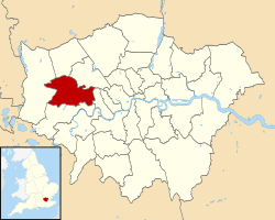 Ealing shown within Greater London | |||
| Sovereign state | United Kingdom | ||
| Constituent country | England | ||
| Region | London | ||
| Ceremonial county | Greater London | ||
| Status | London borough | ||
| Admin HQ | Ealing Town Hall, Uxbridge Road, Ealing | ||
| Created | 1 April 1965 | ||
| Government | |||
| • Type | London borough council | ||
| • Body | Ealing London Borough Council | ||
| • Leadership |
Leader & Cabinet - Cllr Julian Bell | ||
| • Mayor | Cllr Dr Patricia Walker | ||
| • MPs |
Stephen Pound Rupa Huq Virendra Sharma | ||
| • London Assembly | Onkar Sahota AM for Ealing and Hillingdon | ||
| • EU Parliament | London | ||
| Area | |||
| • Total | 21.44 sq mi (55.53 km2) | ||
| Area rank | 265th (of 326) | ||
| Population (mid-2014 est.) | |||
| • Total | 342,118 | ||
| • Rank | 15th (of 326) | ||
| • Density | 16,000/sq mi (6,200/km2) | ||
| • Ethnicity[1] |
30.4% White British | ||
| • ONS code | 00AJ | ||
| Time zone | GMT (UTC0) | ||
| • Summer (DST) | BST (UTC+1) | ||
| Postcodes | HA, NW, UB, W | ||
| Area code(s) | 020 | ||
| Police force | Metropolitan Police | ||
| Website |
www | ||
The London Borough of Ealing ![]() i/ˈiːlɪŋ/ is a London Borough in west London, England, and forms part of Outer London. It is the 3rd largest London Borough in population, and 11th largest in size, covering part of west London and a small part of north west London. Its administrative centre is Ealing Broadway. Other major centres include Acton, Greenford and Southall. The local authority is Ealing London Borough Council.
i/ˈiːlɪŋ/ is a London Borough in west London, England, and forms part of Outer London. It is the 3rd largest London Borough in population, and 11th largest in size, covering part of west London and a small part of north west London. Its administrative centre is Ealing Broadway. Other major centres include Acton, Greenford and Southall. The local authority is Ealing London Borough Council.
Location
The London Borough of Ealing borders the London Borough of Hillingdon to the west, the London Borough of Harrow and the London Borough of Brent to the north, the London Borough of Hammersmith and Fulham to the east and the London Borough of Hounslow to the south.
The London borough was formed in 1965 by the merging the area of the Municipal Borough of Ealing, the Municipal Borough of Southall and the Municipal Borough of Acton.
Along with Brentford, the London Borough of Ealing is the setting for much of the action in Robert Rankin's series of comedic novels, The Brentford Trilogy, which currently consists of six volumes. Ealing is also the primary setting for The Sarah Jane Adventures, being the location of Sarah Jane Smith's home.
Within the borough are two garden suburbs, Brentham Garden Suburb and Bedford Park.
330 hectares within the borough are designated as part of the Metropolitan Green Belt.
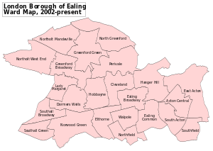
Districts
Parliamentary constituencies in Ealing
London Fire Brigade
There are four fire stations within the London Borough of Ealing. Southall and Northolt have similar-sized station grounds and both house two pumping appliances. Southall attended some 700 incidents more than their Northolt counterparts in 2006/07. Ealing, with two pumping appliances, and Acton, one pump and two fire investigation units, are the other two appliances in the area. Interestingly, the ward of Northfield had over forty malicious calls made from it, more than twice as any other ward within Ealing.[2]
Education
Ealing has a total of 91 state-run schools and nurseries. There are 13 high schools under the domain of the local education authority, 12 of which are either comprehensive, foundation or voluntary-aided, and one city academy.
A number of successful independent schools, including Avenue House School (co-ed, ages 3 – 11), St Benedict's School, Ealing|St Benedict's School (co-ed), the Barbara Speake Stage School (co-ed, ages 4 – 16), St Augustine's Priory, Ealing|St Augustine's Priory (girls) and Notting Hill & Ealing High School (girls), are also located within the borough. The King Fahd Academy is an independent Saudi funded school within the borough.
The Japanese School in London is a Japanese international school in Acton.[3]
Demographics
The borough of Ealing is ethnically diverse. In 2011, 49% gave their ethnicity as white, 30% as Asian, 15% as Black and 4.5% as of mixed or multiple ethnicity, the remander identifying as Arab or other ethnicity.[1] The main religions of the borough's population in 2011 were Christianity (44%), Islam (16%) and Sikhism (8%); 15% stated they had no religion and a further 7% did not state any religion.[4]
Ethnicity-based communities
The borough has a long-standing Irish community which is particularly visible through the number of established Irish pubs in the borough and the popularity of Gaelic games in the community. Country flags for example can be seen flown on the outside or hung inside of various pubs in the area, especially on St Patrick's Day. St Benedict's School has also had a long term affiliation with the Irish community in Ealing, as it is a Catholic school. Many Irish members of the Ealing borough attend Ealing Abbey which is linked to St Benedict's School. The Irish population is mostly concentrated within Hanwell.
Ealing has a large British-Polish community that owes its origins to the World War II refugees and Polish armed forces finding both cheap accommodation and work in the Acton area, which then had a high proportion of London's light engineering companies involved with government war contracts. This community has grown considerably including more shops with authentic Polish food since Poland joined the EU and its migrant workers have been able to come to the UK freely; in 2011 the borough had the UK's highest proportion of Polish speakers at 6% of the population.[5] This has also led to an increase in Polish social centres in the borough. The population is highly concentrated in Acton, Greenford and Perivale.
Southall in the west of the borough is home to one of the largest South Asian communities in the UK, the majority of whom are Sikhs.[6][7][8][9][10] The community first developed in the 1950s. The Asian population makes up 80% of Southall Broadway ward as of 2011, a contrast compared to the 8% of Southfield ward in the borough's east.
There are also churches and centres for London's Hungarian[11] and Assyrian communities in South Ealing.
Other demographics
As of the 2011 census, Hanger Hill had, at 13%, the largest proportion of people aged 65 and over. The lowest were East Acton and Southall Green, at 8% each.[12]
Sport and leisure
Brentford F.C. draw a large amount of local support from the borough, although Griffin Park is situated just outside the borough, in the neighbouring London Borough of Hounslow.
The borough is represented in Rugby Union by Ealing Trailfinders and in Rugby League by the London Broncos.
The borough has four Non-League football clubs Hanwell Town F.C. and Southall F.C. which both play at Reynolds Field in Perivale. the other two clubs are London Tigers F.C., which plays at the Avenue Park Stadium in Greenford and North Greenford United F.C., which plays at Berkeley Fields.
Transport
Rail and London Underground
The numerous National Rail and London Underground stations in the borough are:
- Acton Central railway station
- Acton Main Line railway station
- Acton Town tube station
- Boston Manor tube station
- Castle Bar Park railway station
- Chiswick Park tube station
- Drayton Green railway station
- Ealing Broadway station
- Ealing Common tube station
- Greenford station
- Hanger Lane tube station
- Hanwell railway station
- North Acton tube station
- North Ealing tube station
- Northfields tube station
- Northolt Park railway station
- Northolt tube station
- Park Royal tube station
- Perivale tube station
- South Acton railway station
- South Ealing tube station
- South Greenford railway station
- Southall railway station
- West Acton tube station
- West Ealing railway station
Buses
London Buses routes 7, 65, 70, 72, 83, 90, 92, 94, 95, 105, 112, 120, 140, 187, 195, 207, 224, 226, 228, 260, 266, 272, 282, 283, 297, 395, 398, 427, 440, 482, 487, 607, E1, E2, E3, E5, E6, E7, E8, E9, E10, E11, H17, H32, other routes 895, Night route N7, N11 and N207.
Travel to work
In March 2011, the main forms of transport that residents used to travel to work were: driving a car or van, 21.8% of all residents aged 16–74; underground, metro, light rail, tram, 9.2%; bus, minibus or coach, 9.2%; on foot, 4.7%; train, 4.0%; work mainly at or from home, 3.0%; bicycle, 2.0%.[13]
Transport development
In April 2009 the council voted to call on Transport for London to look into the proposal for a North and West London Light Railway.[14]
Town twinning
Ealing is twinned with:
 The district of Bielany, Warsaw, Masovian Voivodeship, Poland;
 The town of Marcq-en-Barœul, Nord, Hauts-de-France, France;
 The district of Steinfurt, North Rhine-Westphalia, Germany[15]
References
- 1 2 2011 Census: Ethnic group, local authorities in England and Wales, Office for National Statistics (2012). See Classification of ethnicity in the United Kingdom for the full descriptions used in the 2011 Census.
- ↑ London-fire.gov.uk
- ↑ "Home." Japanese School in London. Retrieved on 1 January 2014. "所在地:87 CREFFIELD ROAD, ACTON, LONDON, W3 9PU, U.K."
- ↑ 2011 Census: KS209EW Religion, local authorities in England and Wales, Office for National Statistics (2012).
- ↑ England's second language is Polish | UK | Express.co.uk - Home of the Daily and Sunday Express
- ↑ Harcourt, Gordon (4 May 2005). "British Asians' immigration fears". BBC News. Retrieved 2009-03-21.
- ↑ Philipose, Pamela (13 July 2003). "Voice from Little India". Indian Express. Retrieved 13 December 2009.
- ↑ Dhaliwal, Nirpal (22 July 2007). "Cameron is given a black eye by the real Southall". The Sunday Times. London. Retrieved 13 December 2009.
- ↑ Bhamra, Kuljit (6 April 2009). "The (untold) Southall Story". Asians in Media Magazine. Retrieved 13 December 2009.
- ↑ Rappeport, Alan (29 January 2006). "A Real Taste of South Asia? Take the Tube to Southall". New York Times. Retrieved 13 December 2009.
- ↑ "Magyarok Nagyasszonya Főlélkeszség" (in Hungarian). magyarkatolikusok.co.uk. Retrieved 16 April 2013.
- ↑
- ↑ "2011 Census: QS701EW Method of travel to work, local authorities in England and Wales". Office for National Statistics. Retrieved 23 November 2013. Percentages are of all residents aged 16-74 including those not in employment. Respondents could only pick one mode, specified as the journey’s longest part by distance.
- ↑ "Notes Of Council Meeting - 21st April 2009". Ealing Council. Retrieved 24 November 2013.
- ↑ Ealing Council.Twinning. Accessed 2008-09-19
External links
| Wikimedia Commons has media related to London Borough of Ealing. |
| Districts | 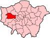 | |
|---|---|---|
| Attractions | ||
| Parks and open spaces |
| |
| Constituencies | ||
| Tube and railway stations |
| |
| Other topics | ||
Coordinates: 51°30′N 0°20′W / 51.500°N 0.333°W